Ratcliff, Arkansas | |
---|---|
Coordinates: 35°18′24″N93°53′19″W / 35.30667°N 93.88861°W | |
Country | United States |
State | Arkansas |
County | Logan |
Area | |
• Total | 1.82 sq mi (4.72 km2) |
• Land | 1.81 sq mi (4.70 km2) |
• Water | 0.01 sq mi (0.02 km2) |
Elevation | 400 ft (100 m) |
Population (2020) | |
• Total | 167 |
• Density | 92.06/sq mi (35.54/km2) |
Time zone | UTC-6 (Central (CST)) |
• Summer (DST) | UTC-5 (CDT) |
ZIP code | 72951 |
Area code | 479 |
FIPS code | 05-58160 |
GNIS feature ID | 2404593 [2] |
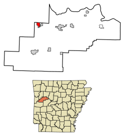
Ratcliff is a city in Logan County, Arkansas, United States. The population was 202 at the 2010 census. [3]
Ratcliff is located in northwestern Logan County and is bordered to the east by the town of Caulksville. Arkansas Highway 22 passes through the center of Ratcliff, leading east through Caulksville 9 miles (14 km) to Paris and west 4 miles (6 km) to Branch.
According to the United States Census Bureau, Ratcliff has a total area of 1.8 square miles (4.7 km2), of which 0.01 square miles (0.02 km2), or 0.42%, are water. [3] The town is on the north side of the valley of Little Creek, a tributary of Sixmile Creek which flows northeast to the Arkansas River.
Census | Pop. | Note | %± |
---|---|---|---|
1910 | 175 | — | |
1920 | 257 | 46.9% | |
1930 | 231 | −10.1% | |
1940 | 337 | 45.9% | |
1950 | 213 | −36.8% | |
1960 | 147 | −31.0% | |
1970 | 184 | 25.2% | |
1980 | 197 | 7.1% | |
1990 | 180 | −8.6% | |
2000 | 191 | 6.1% | |
2010 | 202 | 5.8% | |
2020 | 167 | −17.3% | |
U.S. Decennial Census [4] |
As of the census [5] of 2000, there were 191 people, 76 households, and 57 families residing in the city. The population density was 103.2 inhabitants per square mile (39.8/km2). There were 86 housing units at an average density of 46.5 per square mile (18.0/km2). The racial makeup of the city was 98.43% White, 0.52% Native American, and 1.05% from two or more races. 1.57% of the population were Hispanic or Latino of any race.
There were 76 households, out of which 30.3% had children under the age of 18 living with them, 63.2% were married couples living together, 9.2% had a female householder with no husband present, and 23.7% were non-families. 19.7% of all households were made up of individuals, and 9.2% had someone living alone who was 65 years of age or older. The average household size was 2.51 and the average family size was 2.88.
In the city, the population was spread out, with 23.6% under the age of 18, 9.4% from 18 to 24, 27.7% from 25 to 44, 26.7% from 45 to 64, and 12.6% who were 65 years of age or older. The median age was 37 years. For every 100 females, there were 96.9 males. For every 100 females age 18 and over, there were 102.8 males.
The median income for a household in the city was $23,000, and the median income for a family was $27,500. Males had a median income of $27,500 versus $16,875 for females. The per capita income for the city was $13,530. About 15.5% of families and 20.5% of the population were below the poverty line, including 21.4% of those under the age of eighteen and 22.6% of those 65 or over.
Logan County is a county located in the U.S. state of Arkansas. As of the 2020 census, the population was 21,131. Its two county seats are Booneville and Paris.
Menifee is a town in Conway County, Arkansas, United States. The population was 302 at the 2010 census.
Hartman is a city in Johnson County, Arkansas, United States. The population was 519 at the 2010 census.
Caulksville is a town in Logan County, Arkansas, United States. The population was 213 at the 2010 census.
Magazine is a city in Logan County, Arkansas, United States. The population was 847 at the 2010 census. The city is named for nearby Mount Magazine.
Morrison Bluff is a town in Logan County, Arkansas, United States. The population was 64 at the 2010 census and an estimated 81 in 2017.
Scranton is a city in Logan County, Arkansas, United States. The population was 224 at the 2010 census. It was named after Scranton, Pennsylvania.
Humnoke is a city in Lonoke County, Arkansas, United States. The population was 284 at the 2010 census. It is part of the Little Rock–North Little Rock–Conway Metropolitan Statistical Area.
Hackett is a city in Sebastian County, Arkansas, United States. It is part of the Fort Smith, Arkansas-Oklahoma Metropolitan Statistical Area. The population was 812 at the 2010 census.
Logan is a city and county seat of Harrison County, Iowa, United States, along the Boyer River. The population was 1,397 at the time of the 2020 census.
Dixon is a city in Scott County, Iowa, United States. The population was 202 at the time of the 2020 census.
Logan is a city in Phillips County, Kansas, United States. As of the 2020 census, the population of the city was 460.
Morrison Township is a township in Aitkin County, Minnesota, United States. The population was 200 as of the 2010 census.
Garfield is a city in Douglas County, Minnesota, United States. The population was 349 at the 2020 census.
Bigfork Township is a township in Itasca County, Minnesota, United States. The population was 321 at the 2010 census.
Warba is a city in Itasca County, Minnesota, United States. The population was 168 at the 2020 census.
Clarissa is a city in Todd County, Minnesota, United States. The population was 681 at the 2010 census. It dropped to 661 inhabitants by the 2020 census.
Rushsylvania is a village located in Logan County, Ohio, United States. The population was 491 at the 2020 census.
Pinhook Corners is a census-designated place (CDP) in Sequoyah County, Oklahoma, United States. It is part of the Fort Smith, Arkansas-Oklahoma Metropolitan Statistical Area. The population was 161 at the 2000 census.
West Logan is a town along the Guyandotte River in Logan County, West Virginia, United States. The population was 400 at the 2020 census. For unknown reasons, some sources report West Logan to lay west of the county seat at Logan, attributing to this fact the name.