Branch | |
---|---|
City | |
Coordinates: 35°18′27″N93°57′21″W / 35.30750°N 93.95583°W | |
Country | United States |
State | Arkansas |
County | Franklin |
Area | |
• Total | 3.13 sq mi (8.09 km2) |
• Land | 3.12 sq mi (8.09 km2) |
• Water | 0.00 sq mi (0.00 km2) |
Elevation | 469 ft (143 m) |
Population (2020) | |
• Total | 296 |
• Density | 94.78/sq mi (36.59/km2) |
Time zone | UTC-6 (Central (CST)) |
• Summer (DST) | UTC-5 (CDT) |
ZIP code | 72928 |
Area code | 479 |
FIPS code | 05-08440 |
GNIS feature ID | 2403912 [2] |
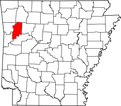
Branch is a city in Franklin County, Arkansas, United States. It is part of the Fort Smith, Arkansas-Oklahoma Metropolitan Statistical Area. The population was 367 at the 2010 census. [3]
Branch is located in southwestern Franklin County at the junctions of Arkansas Highways 22 and 41. Highway 22 leads east 5 miles (8 km) to Caulksville and west 5 miles (8 km) to Charleston, while Highway 41 leads north 10 miles (16 km) to Cecil and south 14 miles (23 km) to Booneville. Fort Smith is 28 miles (45 km) to the west.
According to the United States Census Bureau, Branch has a total area of 3.6 square miles (9.2 km2), all land. [3]
Census | Pop. | Note | %± |
---|---|---|---|
1910 | 271 | — | |
1920 | 370 | 36.5% | |
1930 | 318 | −14.1% | |
1940 | 390 | 22.6% | |
1950 | 308 | −21.0% | |
1960 | 258 | −16.2% | |
1970 | 325 | 26.0% | |
1980 | 353 | 8.6% | |
1990 | 299 | −15.3% | |
2000 | 357 | 19.4% | |
2010 | 367 | 2.8% | |
2020 | 296 | −19.3% | |
U.S. Decennial Census [4] 2014 Estimate [5] |
As of the census [6] of 2000, there were 357 people, 141 households, and 106 families residing in the city. The population density was 100.1 inhabitants per square mile (38.6/km2). There were 155 housing units at an average density of 43.5 per square mile (16.8/km2). The racial makeup of the city was 96.08% White, 1.68% Native American, 0.84% Asian, 0.56% from other races, and 0.84% from two or more races. 0.56% of the population were Hispanic or Latino of any race.
There were 141 households, out of which 31.9% had children under the age of 18 living with them, 63.8% were married couples living together, 6.4% had a female householder with no husband present, and 24.8% were non-families. 21.3% of all households were made up of individuals, and 7.8% had someone living alone who was 65 years of age or older. The average household size was 2.53 and the average family size was 2.92.
In the city, the population was spread out, with 24.4% under the age of 18, 7.0% from 18 to 24, 29.7% from 25 to 44, 24.6% from 45 to 64, and 14.3% who were 65 years of age or older. The median age was 37 years. For every 100 females, there were 108.8 males. For every 100 females age 18 and over, there were 103.0 males.
The median income for a household in the city was $29,531, and the median income for a family was $33,750. Males had a median income of $21,875 versus $17,266 for females. The per capita income for the city was $15,317. About 6.9% of families and 9.9% of the population were below the poverty line, including 16.9% of those under age 18 and none of those age 65 or over.
Franklin County is a county in Arkansas. As of the 2020 census, the population was 17,097. The county has two county seats, Charleston and Ozark. The county was formed on December 19, 1837, and named for Benjamin Franklin, American statesman. Franklin County is a damp county, with alcohol sales allowed except in Prairie & Alix townships, and limits on liquor sales in the city of Branch.
Salesville is a city in Baxter County, Arkansas, United States. The population was 450 in 2010.
Decatur is a city, in Benton County, Arkansas, United States. The population was 1,773 at the 2020 census. It is part of the Northwest Arkansas region. This town is named after Commodore Stephen Decatur, Jr.
Lowell is a city in Benton County, Arkansas, United States. Located within the Ozarks, first settlement was along Old Wire Road in the 1840s, and although destroyed during the Civil War, the community was reestablished by J. R. McClure and thrived when the St. Louis–San Francisco Railway came through the area in the 1880s. Today, the city is a growing bedroom community within the rapidly growing Northwest Arkansas region. Lowell is also home to the headquarters of trucking company J.B. Hunt. Lowell's population was 9,839 at the 2020 census, an increase of 34% since 2010.
Sulphur Springs is a city in Benton County, Arkansas, United States. The population was 481 at the 2020 census. It is part of the Northwest Arkansas region.
Berryville is a city in Carroll County, Arkansas, United States. The population was 5,682 at the 2020 census. making it the largest city in Carroll County. Along with Eureka Springs, it is one of the two county seats of Carroll County.
Quitman is a city in Cleburne and Faulkner counties in the U.S. state of Arkansas. Its population was 762 at the 2010 census. The portion of the city in Faulkner County is part of the Central Arkansas region.
Brookland is a city in Craighead County, Arkansas, United States. The population was 1,642 at the 2010 census. It is included in the Jonesboro, Arkansas Metropolitan Statistical Area.
Cedarville is a city in Crawford County, Arkansas, United States. It is part of the Fort Smith, Arkansas-Oklahoma Metropolitan Statistical Area. The population was 1,410 at the 2020 census.
Guy is a city in Faulkner County, Arkansas, United States. The population was 708 at the 2010 census, up from 202 at the 2000 census. It is part of the Central Arkansas region.
Charleston is a city in Franklin County, Arkansas, United States, and along with Ozark is one of the two county seats of Franklin County. It is part of the Fort Smith, Arkansas-Oklahoma Metropolitan Statistical Area. The population was 2,494 at the 2010 census, down from 2,965 in 2000.
Lafe is a town in Greene County, Arkansas, United States on Crowley's Ridge. The population was 448 at the 2010 census, up from 385 in 2000.
Blevins is a city in Hempstead County, Arkansas, United States. The population was 315 at the 2010 census, down from 365 in 2000. It is part of the Hope Micropolitan Statistical Area.
Mineral Springs is a city in Howard County, Arkansas, United States. The population was 1,208 at the 2010 census.
Bradley is a city in Lafayette County, Arkansas, United States. The population was 628 at the 2010 census.
Ratcliff is a city in Logan County, Arkansas, United States. The population was 202 at the 2010 census.
Scranton is a city in Logan County, Arkansas, United States. The population was 224 at the 2010 census. It was named after Scranton, Pennsylvania.
Hindsville is a town in Madison County, Arkansas, United States. The population was 90 at the 2020 census. It is part of the Northwest Arkansas region.
Huntsville is a city in and county seat of Madison County, Arkansas, United States. The population was 2,879 at the 2020 census, up from 2,346 in 2010. During the American Civil War in 1862, it was the site of what became known as the Huntsville Massacre. Huntsville is part of the Northwest Arkansas region.
Summit is a city in Marion County, Arkansas, United States. The population was 544 at the 2020 census, down from 604 in 2010.