Denning, Arkansas

Last updated

Denning, Arkansas
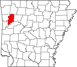
Franklin County Arkansas Incorporated and Unincorporated areas Denning Highlighted 0518370.svg
Location of Denning in Franklin County, Arkansas.
Coordinates: 35°25′31″N93°45′24″W / 35.42528°N 93.75667°W / 35.42528; -93.75667
Country United States
State Arkansas
County Franklin
Area
[1]
  Total1.08 sq mi (2.79 km2)
  Land1.08 sq mi (2.79 km2)
  Water0.00 sq mi (0.00 km2)
Elevation
[2]
420 ft (130 m)
Population
 (2020)
  Total200
  Density185.70/sq mi (71.67/km2)
Time zone UTC-6 (Central (CST))
  Summer (DST) UTC-5 (CDT)
FIPS code 05-18370
GNIS feature ID2406374 [2]

Denning is a town in Franklin County, Arkansas, United States. It is part of the Fort Smith, Arkansas-Oklahoma Metropolitan Statistical Area. The population was 314 at the 2010 census, [3] up from 270 at the 2000 census.

Contents

Geography

Denning is located in southeastern Franklin County and is bordered to the north by the city of Altus.

According to the United States Census Bureau, the town has a total area of 1.1 square miles (2.8 km2), all land. [3]

It sustained a direct hit from a tornado during the late-May 2011 tornado outbreak.

Demographics

Historical population
CensusPop.Note
1910 757
1920 608−19.7%
1930 384−36.8%
1940 341−11.2%
1950 268−21.4%
1960 227−15.3%
1970 203−10.6%
1980 23817.2%
1990 206−13.4%
2000 27031.1%
2010 31416.3%
2020 200−36.3%
U.S. Decennial Census [4]
2014 Estimate [5]

As of the census [6] of 2000, there were 270 people, 102 households, and 75 families residing in the town. The population density was 94.8 people/km2 (246 people/sq mi). There were 115 housing units at an average density of 40.4 units/km2 (105 units/sq mi). The racial makeup of the town was 95.19% White, 0.37% Black or African American, 0.74% Native American, 1.85% Asian, and 1.85% from two or more races. 2.22% of the population were Hispanic or Latino of any race.

There were 102 households, out of which 33.3% had children under the age of 18 living with them, 60.8% were married couples living together, 5.9% had a female householder with no husband present, and 25.5% were non-families. 22.5% of all households were made up of individuals, and 12.7% had someone living alone who was 65 years of age or older. The average household size was 2.65 and the average family size was 3.04.

In the town, the population was spread out, with 26.3% under the age of 18, 6.7% from 18 to 24, 28.9% from 25 to 44, 20.0% from 45 to 64, and 18.1% who were 65 years of age or older. The median age was 39 years. For every 100 females, there were 100.0 males. For every 100 females age 18 and over, there were 97.0 males.

The median income for a household in the town was $23,750, and the median income for a family was $32,708. Males had a median income of $19,792 versus $17,344 for females. The per capita income for the town was $12,487. About 22.8% of families and 21.8% of the population were below the poverty line, including 18.4% of those under the age of eighteen and 9.8% of those 65 or over.

Education

Denning is served by the Ozark School District, leading to graduation at Ozark High School. The Altus-Denning School District was closed in 2004 after an Arkansas law was passed requiring many small schools in the state to consolidate, usually with a bigger school close by. Prior to closing the Altus-Denning High School mascot was the Owls and competed in the 1A classification of the Arkansas Activities Association (AAA).

Related Research Articles

<span class="mw-page-title-main">Franklin County, Arkansas</span> County in Arkansas, United States

Franklin County is a county in Arkansas. As of the 2020 census, the population was 17,097. The county has two county seats, Charleston and Ozark. The county was formed on December 19, 1837, and named for Benjamin Franklin, American statesman. Franklin County is a damp county, with alcohol sales allowed except in Prairie & Alix townships, and limits on liquor sales in the city of Branch.

<span class="mw-page-title-main">Montrose, Arkansas</span> City in Arkansas, United States

Montrose is a city in Ashley County, Arkansas, United States. The population was 354 at the 2010 census. Montrose is located where U.S. Route 165 intersects with U.S. Route 82. The town was heavily damaged by an EF2 tornado on January 2, 2023.

<span class="mw-page-title-main">Gateway, Arkansas</span> Town in Arkansas, United States

Gateway is a town in Benton County, Arkansas, United States. The population was 436 at the 2020 census, up from 405 in 2010. It is part of the Northwest Arkansas region. The town's name reflects its situation as the "gateway" to and from Arkansas.

<span class="mw-page-title-main">Everton, Arkansas</span> Town in Arkansas, United States

Everton is a town in Boone County, Arkansas, United States. The population was 133 at the 2010 census. It is part of the Harrison Micropolitan Statistical Area.

<span class="mw-page-title-main">Lead Hill, Arkansas</span> Town in Arkansas, United States

Lead Hill is a town in Boone County, Arkansas, United States. The population was 271 at the 2010 census. It is part of the Harrison Micropolitan Statistical Area.

<span class="mw-page-title-main">Altus, Arkansas</span> City in Arkansas, United States

Altus is a city in Franklin County, Arkansas, United States. Located within the Arkansas River Valley at the edge of the Ozark Mountains, the city is within the Fort Smith metropolitan area. The epicenter of the Altus American Viticultural Area (AVA) within Arkansas Wine Country, the city is home to four wineries. Although founded as a coal mining community, the wine industry has driven the Altus economy since the first vineyards were planted in 1872. The population was 758 at the 2010 census, down from 817 at the 2000 census. In 2020, the population was 669 and was estimated as unchanged in 2021 and 2022.

<span class="mw-page-title-main">Hartman, Arkansas</span> City in Arkansas, United States

Hartman is a city in Johnson County, Arkansas, United States. The population was 519 at the 2010 census.

<span class="mw-page-title-main">St. Paul, Arkansas</span> Town in Arkansas, United States

St. Paul is a town in Madison County, Arkansas, United States. The population was 111 at the 2020 census. It is on the edge of the Northwest Arkansas region.

<span class="mw-page-title-main">Pyatt, Arkansas</span> Town in Arkansas, United States

Pyatt is a town in western Marion County, Arkansas, United States. The population was 181 at the 2020 census, down from 221 in 2010.

<span class="mw-page-title-main">Western Grove, Arkansas</span> Town in Arkansas, United States

Western Grove is a town in northeastern Newton County, Arkansas, United States. The population was 384 at the 2010 census. It is part of the Harrison Micropolitan Statistical Area.

<span class="mw-page-title-main">Hector, Arkansas</span> Town in Arkansas, United States

Hector is a town in Pope County, Arkansas, United States. The population was 450 at the 2010 census. It is part of the Russellville Micropolitan Statistical Area.

<span class="mw-page-title-main">London, Arkansas</span> City in Arkansas, United States

London is a city in Pope County, Arkansas, United States. The population was 1,039 at the 2010 census. It is part of the Russellville Micropolitan Statistical Area.

<span class="mw-page-title-main">Pindall, Arkansas</span> Town in Arkansas, United States

Pindall is a town in Searcy County, Arkansas, United States. The population was 112 at the 2010 census. The town is said to be named for Governor Xenophon Overton Pindall.

<span class="mw-page-title-main">Mountain View, Arkansas</span> City in Arkansas, United States

Mountain View is the largest city in and the county seat of Stone County, Arkansas, United States, located in the Ozarks. The city's economy is largely based on tourism related to its title as the "Folk Music Capital of the World". The city is also known for outdoors recreation opportunities, including Blanchard Springs Caverns, trout fishing on the White River and the Ozark National Forest.

<span class="mw-page-title-main">Clinton, Arkansas</span> City in Arkansas, United States

Clinton is the county seat of Van Buren County, Arkansas, United States. The population was 2,602 at the 2010 census, making it the most populous city in the county.

<span class="mw-page-title-main">Goshen, Arkansas</span> City in Arkansas, United States

Goshen is a city in Washington County, Arkansas, United States. The population was 2,102 at the 2020 census. It is part of the Northwest Arkansas region. According to Business Insider, it is the “most educated” city in the state of Arkansas.

<span class="mw-page-title-main">Wiederkehr Village, Arkansas</span> City in Arkansas, United States

Wiederkehr Village is a city in Franklin County, Arkansas, United States. It is part of the Fort Smith, Arkansas-Oklahoma Metropolitan Statistical Area. The population was 38 at the 2010 census. It is named after Swiss winemaker Johann Andreas Wiederkehr, who immigrated to the area in 1880.

<span class="mw-page-title-main">Ozark, Missouri</span> City in Missouri, United States

Ozark is a city in and the county seat of Christian County, Missouri. Its population was 21,284 as of the 2020 census. Ozark is also the third largest city in the Springfield, Missouri Metropolitan Area, and is centered along a business loop of U.S. Route 65, where it intersects with Missouri Route 14.

<span class="mw-page-title-main">Pierce City, Missouri</span> City in Missouri, United States

Pierce City, formerly Peirce City, is a city in southwest Lawrence and northwest Barry counties, in southwest Missouri, United States. The population was 1,292 at the 2010 census. In 2010, the town annexed property along Route 97 into Barry County to a point just north of U.S. Route 60. It was estimated to be 1,309 by the City of Pierce City as of July 1, 2019.

<span class="mw-page-title-main">Lula, Mississippi</span> Town in Mississippi, United States

Lula is a town in Coahoma County, Mississippi, United States. Per the 2020 census, the population was 204.

References

  1. "2020 U.S. Gazetteer Files". United States Census Bureau. Retrieved October 29, 2021.
  2. 1 2 U.S. Geological Survey Geographic Names Information System: Denning, Arkansas
  3. 1 2 "Geographic Identifiers: 2010 Census Summary File 1 (G001): Denning town, Arkansas". American Factfinder. U.S. Census Bureau. Archived from the original on February 13, 2020. Retrieved April 20, 2016.
  4. "Census of Population and Housing". Census.gov. Retrieved June 4, 2015.
  5. "Annual Estimates of the Resident Population for Incorporated Places: April 1, 2010 to July 1, 2014". Archived from the original on May 22, 2015. Retrieved June 4, 2015.
  6. "U.S. Census website". United States Census Bureau . Retrieved January 31, 2008.