Peanut, Arkansas | |
|---|---|
 Peanut, Arkansas  Peanut, Arkansas | |
| Coordinates: 35°40′31″N93°42′18″W / 35.67528°N 93.70500°W | |
| Country | United States |
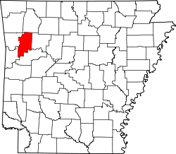
| State | Arkansas |
| County | Franklin |
| Elevation | 846 ft (258 m) |
| Time zone | UTC-6 (Central (CST)) |
| • Summer (DST) | UTC-5 (CDT) |
| GNIS feature ID | 73027 [1] |
Peanut is an unincorporated community in eastern Franklin County, Arkansas, United States. [1]
The settlement is located on the south edge of the Mulberry River floodplain at the confluence with Clear Creek and approximately one-half mile from the Franklin-Johnson county line. The community is within the Ozark–St. Francis National Forest. [2] Ozark lies approximately thirteen miles to the south-southwest. Arkansas Highway 215 passes on the north side of the river floodplain. [3]
Prior to 1945, the settlement was called "Taft", and Taft at one time had a post office. [4]
In 1975, there was one house located in Peanut. [4]