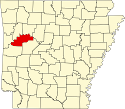
Tokalon, Arkansas

Last updated
Tokalon, Arkansas
USA Arkansas location map.svg
Red pog.svg
Tokalon, Arkansas
Usa edcp location map.svg
Red pog.svg
Tokalon, Arkansas
Coordinates: 35°22′35″N93°28′17″W / 35.37639°N 93.47139°W / 35.37639; -93.47139 Coordinates: 35°22′35″N93°28′17″W / 35.37639°N 93.47139°W / 35.37639; -93.47139
Country United States
State Arkansas
County Logan
Elevation
436 ft (133 m)
Time zone UTC-6 (Central (CST))
  Summer (DST) UTC-5 (CDT)
Area code(s) 479
GNIS feature ID55588 [1]

Tokalon is an unincorporated community in Logan County, Arkansas, United States. [1] [2]

Notes

  1. 1 2 "Tokalon, Arkansas". Geographic Names Information System . United States Geological Survey, United States Department of the Interior.
  2. Tokalon Topo Map in Logan County AR

Related Research Articles

Pope County, Arkansas County in Arkansas, United States

Pope County is a county in the U.S. state of Arkansas. As of the 2010 census, the population was 61,754. The county seat is Russellville. The county was formed on November 2, 1829, from a portion of Crawford County and named for John Pope, the third governor of the Arkansas Territory. It is an alcohol prohibition or dry county.

Logan County, Arkansas County in Arkansas, United States

Logan County is a county located in the U.S. state of Arkansas. As of the 2010 census, the population was 22,353. Its two county seats are Booneville and Paris.

Johnson County, Arkansas County in Arkansas, United States

Johnson County is a county located in the U.S. state of Arkansas. As of the 2010 census, the population was 25,540. The county seat is Clarksville. Johnson County is Arkansas's 30th county, formed on November 16, 1833, from a portion of Pope County and named for Benjamin Johnson, a Territorial Judge. It is an alcohol prohibition or dry county.

Independence County, Arkansas County in Arkansas, United States

Independence County is a county located in the U.S. state of Arkansas. As of the 2010 census, the population was 36,647. The county seat is Batesville. Independence County is Arkansas's ninth county, formed on October 20, 1820, from a portion of Lawrence County and named in commemoration of the Declaration of Independence. It is an alcohol prohibition or dry county.

Franklin County, Arkansas County in Arkansas, United States

Franklin County is a county in Arkansas. As of the 2010 census, the population was 18,125. The county has two county seats, Charleston and Ozark. The county was formed on December 19, 1837, and named for Benjamin Franklin, American statesman. To the north of the Arkansas River, which bisects Franklin County, the county is wet and alcohol is sold in liquor stores, bars and local vineyards. To the south of the Arkansas River, the county is dry.

Paris, Arkansas City in Arkansas, United States

Paris is a city in Logan County, Arkansas, United States, and serves as the county seat for the northern district of Logan County; its southern district counterpart is Booneville. Its population was 3,176 as of the 2020 U.S. Census.

The United States District Court for the Western District of Arkansas is a federal court in the Eighth Circuit.

James A. Logan was an early settler, politician and United States Indian agent in western Arkansas. Logan County was named for him in 1875.

Logan H. Roots American politician

Logan Holt Roots was a U.S. Representative for Arkansas' 1st congressional district.

New Blaine, Arkansas Census-designated place in Arkansas, United States

New Blaine is an unincorporated community and census-designated place (CDP) in Logan County, Arkansas, United States. Per the 2020 census, the population was 173.

National Register of Historic Places listings in Logan County, Arkansas

This is a list of the National Register of Historic Places listings in Logan County, Arkansas.

Midway is an unincorporated community in Logan County, Arkansas, United States. Midway is located at the junction of Arkansas highways 22 and 109, 6 miles (9.7 km) east of Subiaco.

1996 United States presidential election in Arkansas Election in Arkansas

The 1996 United States presidential election in Arkansas took place on November 5, 1996, as part of the 1996 United States presidential election. State voters chose six electors to the Electoral College, who voted for president and vice president.

Arkansas River Valley Region in Arkansas, United States

The Arkansas River Valley is a region in Arkansas defined by the Arkansas River in the western part of the state. Generally defined as the area between the Ozark and Ouachita Mountains, the River Valley is characterized by flat lowlands covered in fertile farmland and lakes periodically interrupted by high peaks. Mount Magazine, Mount Nebo, and Petit Jean Mountain compose the Tri-Peaks Region, a further subdivision of the River Valley popular with hikers and outdoors enthusiasts. In addition to the outdoor recreational activities available to residents and visitors of the region, the River Valley contains Arkansas's wine country as well as hundreds of historical sites throughout the area. It is one of six natural divisions of Arkansas.

Delaware is an unincorporated community in Logan County, Arkansas, United States. Delaware is located on Lake Dardanelle at the junction of Arkansas highways 22 and 393, 9 miles (14 km) northwest of Dardanelle. Delaware has a post office with ZIP code 72835.

Prairie View is an unincorporated community in Logan County, Arkansas, United States. Prairie View is located at the junction of Arkansas highways 109 and 288, 2 miles (3.2 km) south-southeast of Scranton.

Pleasant Hill is an unincorporated community in Logan County, Arkansas, United States. Pleasant Hill is located on Arkansas Highway 197, 7.25 miles (11.67 km) east-northeast of Paris.

Pleasant Hill is an unincorporated community in Logan County, Arkansas, United States. Pleasant Hill is 3 miles (4.8 km) northeast of Magazine.

Logan is an unincorporated community in Benton County, Arkansas, United States, located 15.5 miles (24.9 km) southwest of Bentonville. The Gailey Hollow Farmstead and the McIntyre House, both listed on the National Register of Historic Places, are near Logan.

Arkansas Highway 197 State highway designation in Arkansas, United States

Arkansas Highway 197 is the designation for a state highway in the U.S. state of Arkansas. The route is split into three sections, all of which are located in western Arkansas. The first and longest section begins at AR 22 in Subiaco, and ends near Lake Dardanelle southwest of Tokalon. The second section begins at AR 22 in New Blaine, and ends just south of Shoal Bay. The third section begins at AR 10 in Booneville, and ends about 0.3 miles (0.48 km) south. All three signed highways are located within Logan County.