
U.S. Route 64 is a U.S. route running from Teec Nos Pos, Arizona east to Nags Head, North Carolina. In the U.S. state of Arkansas, the route runs 246.35 miles (396.46 km) from the Oklahoma border in Fort Smith east to the Tennessee border in Memphis. The route passes through several cities and towns, including Fort Smith, Clarksville, Russellville, Conway, Searcy, and West Memphis. US 64 runs parallel to Interstate 40 (I-40) until Conway, when I-40 takes a more southerly route.

Chevelon Creek Bridge is a historic road bridge located about 12 miles (19 km) southeast of Winslow, in Navajo County, eastern Arizona, United States. It is a steel Warren Pony truss bridge over Chevelon Creek, built on the first permanent road connecting Holbrook, the seat of Navajo County, and Winslow. When built, the road was regionally important in northern Arizona as well as being a segment of an early national highway at the time automobile traffic was growing and national roads were first being formed. The bridge was listed on the National Register of Historic Places in 1983 for being a rare design in Arizona, part of an early transnational roadway, one of the first bridges built by Arizona after statehood in 1912, and being in nearly original condition.

The Cove Creek Bridge is a historic bridge, carrying Arkansas Highway 309 across Cove Creek, south of the hamlet of Corley, Arkansas in the Ozark-St. Francis National Forest. It is a two-span closed-spandrel masonry arch structure, with each span measuring 13 feet (4.0 m) and an overall structure length of 26 feet (7.9 m). It is built entirely out of stone, with a concrete and asphalt deck, and concrete barriers at the sides. It was built in 1936 with funding support from the Works Progress Administration.
The Lee Creek Bridge in Natural Dam, Arkansas was a Pennsylvania through truss bridge that was built in 1934. It was a twin-span bridge with a total length of 587 feet (179 m), which carried Arkansas Highway 59 across Lee Creek. It rested on concrete piers and abutments, had a vertical clearance of 14 feet (4.3 m) and had a roadbed 22 feet (6.7 m) wide.

U.S. Route 71 is a U.S. route that runs from Krotz Springs, LA to the Fort Frances–International Falls International Bridge at the Canadian border. In Arkansas, the highway runs from the Louisiana state line near Doddridge to the Missouri state line near Bella Vista. In Texarkana, the highway runs along State Line Avenue with US 59 and partially runs in Texas. Other areas served by the highway include Fort Smith and Northwest Arkansas.
The bridge that carries Arkansas Highway 274 across Little Cypress Creek, near Thornton, Arkansas in Calhoun County, was listed on the National Register of Historic Places in 1995. The wooden trestle bridge was built in 1940, and is 105 feet (32 m) long and has a total width of 31 feet (9.4 m), with a deck 28.4 feet (8.7 m) wide. It is divided into seven spans, the longest of which is 15 feet (4.6 m). Its abutments and piers are all of wood, and the bridge deck is wood covered with asphalt.

The Hale Creek Bridge is a historic bridge carrying County Road 271 over Hale Creek in Sevier County, Arkansas, near the village of Red Wing and about halfway between De Queen and Dierks. It consists of a single-span Pratt pony truss 30 feet (9.1 m) long, resting on concrete abutments. The bridge deck is 18 feet (5.5 m) wide and is surfaced in gravel. When the bridge was built in 1919, the roadway it carried was the major east–west route in the area. In 1926 this route was designated U.S. Route 70. It retained this designation until the current alignment of US 70 was built in 1952. The bridge is a fine local example of a Pratt truss bridge.

The Little Cypress Creek Brook is a historic bridge in rural western Phillips County, Arkansas. Located south of the hamlet of Postelle, it carries County Road 600 over Little Cypress Creek, west of Arkansas Highway 39. It consists of two 15-foot (4.6 m) spans of an aluminum-beam substructure, resting on concrete abutments and piers, with textured metal deck plating as the road surface. The bridge was built in 1942, and was probably designed by the engineering staff of the Arkansas State Highway Commission. It is a well-preserved example of a World War II-era bridge.

The Highway B-29 Bridge is a historic bridge in Prairie Grove, Arkansas. It is a single-span concrete arch bridge, carrying Washington County Route 623 across the Illinois River. The arch has a span of 97 feet (30 m), and the total structure length is 100 feet (30 m). Its deck is 17 feet (5.2 m) wide, and the bridge is typically 20 feet (6.1 m) above the water. Built in 1923, the bridge is one of the first built in the county by the Luten Bridge Company, which used an innovative technique involving metal rings that reduced the amount of material required for the structure.

The Frog Bayou Bridge is a historic bridge in Crawford County, Arkansas, just south of Mountainburg. It is a single-span steel Parker through truss, which formerly carried Arkansas Highway 282 across Frog Bayou, a tributary of the Arkansas River. The bridge is now closed to traffic, and is located at the southern end of Silver Bridge Road. The bridge has a span of 150 feet (46 m) and a total structure length of 209 feet (64 m), and rests on abutments of stone and concrete. The northern approach to the bridge also includes a stone and concrete pier. The bridge was built in 1942.

The Sebastian County Road 4G Bridge is a historic bridge in rural Sebastian County, Arkansas, United States. The bridge carries County Road 4 across an unnamed tributary of Sugar Loaf Creek southwest of West Hartford, between County Roads 1 and 243. It has two spans with a total length of 44 feet (13 m). The width is 18 feet (5.5 m) curb-to-curb and 21 feet (6.4 m) overall. The two spans rest on a single center stone pier, and both abutments are also made of stone masonry. The road deck is reinforced concrete with simple concrete railings on the sides. Built in 1940, it is a well-preserved example of a concrete bridge from the World War II era of bridge construction in the state, when steel had become scarce. The bridge was listed on the National Register of Historic Places in 1995.

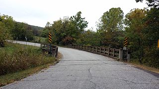
The Hackett Creek Bridge is a historic bridge near Hackett, Arkansas, which carries Arkansas Highway 45 across Hackett Creek. The bridge is a three-span concrete structure set on abutments and piers of stone and concrete. The longest single span is 36 feet (11 m) long, and the total bridge length is 98 feet (30 m). The deck is asphalt laid over concrete, and there are simple concrete railings on either side. Built in 1941, it is a well-preserved concrete bridge of the period.

The Miller Creek Bridge is a historic bridge, carrying Miller Creek Road across Miller Creek, just north of the city limits of Batesville, Arkansas. Built in 1914, it is the state's oldest surviving concrete bridge. It is a two-span arched structure with a total length of 123 feet (37 m), and a width of 12 feet (3.7 m), carrying a single lane of traffic. The bridge is somewhat overengineered, as the use of concrete in bridge construction was then relatively new, and knowledge of the material's properties in this application was not well understood.
The North Sylamore Creek Bridge is a historic bridge in the Ozark-St. Francis National Forest in northern Stone County, Arkansas. It is a Baltimore deck truss bridge, carrying Forest Service Road 1102 over North Sylamore Creek near the Gunner Pool Recreation Area. The bridge has two spans, each 110 feet (34 m) long, with a total structure length of 357 feet (109 m). It rests on concrete piers and abutments. The bridge was built in 1931, and is the only known example of this type of truss in the state.
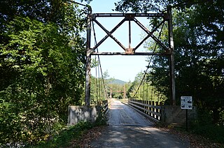
The Sylamore Creek Bridge is a historic bridge in east central Stone County, Arkansas, just south of the Ozark-St. Francis National Forest. It carries County Road 283 across Sylamore Creek, a short way west of Arkansas Highway 9 and north of the Holiday Mountain Resort in Allison. It is a wire-cable suspension bridge, with steel towers mounted on concrete piers supporting four main cables that are anchored into concrete abutments. The bridge is 202 feet (62 m) long, with a deck width of 19 feet 6 inches (5.94 m) and a clearance height of 11 feet (3.4 m). Built in 1945, it is one of three known wire-cable bridges in the state.
The Cannon Creek Bridge is a historic bridge in rural western Madison County, Arkansas. The bridge is located southeast of Durham, carrying County Road 5340 across Cannon and Coon Creeks. It is a curving concrete deck structure with an overall length of about 103 feet (31 m) and a deck width of 20 feet (6.1 m). Built in 1929 to carry Arkansas Highway 16, it is the only known surviving curved concrete deck bridge in the state. It was bypassed by the present alignment of Highway 16 in the 1980s.

The Harp Creek Bridge is a historic bridge in rural northern Newton County, Arkansas, carrying Arkansas Highway 7 across Harp Creek in the hamlet of Harrison. It is an open-spandrel arch bridge, built out of reinforced concrete in 1928 by the Luten Bridge Company. The arches span 69 feet (21 m), and are mounted on piers set 24 feet (7.3 m) from the abutments. The total structure length is 117 feet (36 m), and the deck is 23 feet (7.0 m) wide. Concrete balustrades line the sides of the bridge.

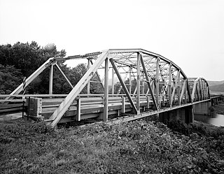
The Big Piney Creek Bridge is a historic bridge, carrying Arkansas Highway 123 across Big Piney Creek in Ozark-St. Francis National Forest, northeast of Hagarville, Arkansas. Its main span is a Warren through truss structure, 141 feet (43 m) in length, with steel deck girder approach spans giving the bridge a total length of 461 feet (141 m). The trusses are mounted on concrete piers. The bridge was built in 1931, during a period of financial hardship, and was for economic reasons built with a single-lane 12-foot (3.7 m) roadway.

The Cove Creek Tributary Bridge is a historic bridge in rural Logan County, Arkansas. It is a two-span closed-spandrel stone arch bridge, carrying Arkansas Highway 309 across a tributary of Cove Creek north of Corley in Ozark-St. Francis National Forest. Each of its arches is 11 feet (3.4 m) long, and the structure is an overall 23 feet (7.0 m) in length. Concrete barriers form the sides of the bridge on either side of the roadway. The bridge was built in 1936 under the auspices of the Arkansas Highway Commission.
The Pine Bluff Arsenal Access Road Bridge No. 2280 is a historic bridge near White Hall, Arkansas. It carries East Hoadley Road over Caney Creek, between the town and the Pine Bluff Arsenal. It is a concrete arch structure, with a total length of 152 feet (46 m). It consists of a concrete deck supported by abutments and four cast concrete piers, carrying a roadway 28 feet (8.5 m) in width. It was built in 1942 with funds authorized by the National Defense Highway Act of 1941, in order to facilitate access between the arsenal and existing transportation networks.

