
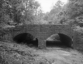
The Carrollton Viaduct, located over the Gwynns Falls stream near Carroll Park in southwest Baltimore, Maryland, is the first stone masonry bridge for railroad use in the United States, built for the Baltimore and Ohio Railroad, founded 1827, and one of the world's oldest railroad bridges still in use for rail traffic. Construction began in 1828 and was completed in 1829. The bridge is named in honor of Charles Carroll of Carrollton (1737–1832), of Maryland, known for being the last surviving signer of the Declaration of Independence, the only Roman Catholic in the Second Continental Congress (1775–1781), and wealthiest man in the Thirteen Colonies of the time of the American Revolutionary War (1775–1783).

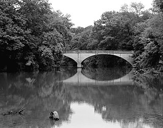
The Thomas Viaduct spans the Patapsco River and Patapsco Valley between Relay, Maryland and Elkridge, Maryland, USA. It was commissioned by the Baltimore and Ohio Railroad (B&O); built between July 4, 1833, and July 4, 1835; and named for Philip E. Thomas, the company's first president. Some claim it to be the world's oldest multiple arched stone railroad bridge. However, the Sankey Viaduct on the Liverpool and Manchester Railway was opened in 1830 and finally completed in 1833.

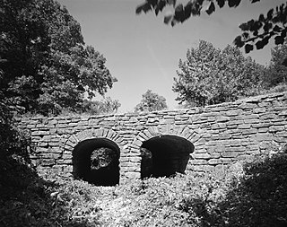
The Patterson Viaduct was built by the Baltimore and Ohio Railroad (B&O) as part of its Old Main Line during May to December 1829. The viaduct spanned the Patapsco River at Ilchester, Maryland. It was heavily damaged by a flood in 1868 and subsequently replaced with other structures. In 2006, it was restored to limited service when a footbridge was built atop the surviving arch and abutments.

Tunkhannock Creek Viaduct is a concrete deck arch bridge on the Nicholson Cutoff rail line segment of the Norfolk Southern Railway Sunbury Line that spans Tunkhannock Creek in Nicholson, Pennsylvania. Measuring 2,375 feet (724 m) long and towering 240 feet (73.15 m) when measured from the creek bed, it was the largest concrete structure in the world when completed in 1915 and still merited "the title of largest concrete bridge in America, if not the world" 50 years later.

The Wilmington Rail Viaduct is a series of fills and bridges, about 4 miles (6.4 km) long, that carries the Northeast Corridor through the city of Wilmington, Delaware, above street level. Constructed between 1902 and 1908, the structure consists principally of fills supported by heavy stone retaining walls, punctuated with plate girder bridges over streets, and augmented by a few sections of brick arch viaduct. Its construction is typical of the Pennsylvania Railroad's architectural practices at the time, and the viaduct has been documented by the Historic American Engineering Record and listed on the National Register of Historic Places. Built by the Pennsylvania Railroad (PRR) as part of a series of grade crossing eliminations along the Northeast Corridor, the elevation of the rail line necessitated several other changes to rail infrastructure in Wilmington, including the construction of the Wilmington Shops at the east end of the viaduct, and the construction of the Wilmington Station and adjacent Pennsylvania Railroad Office Building along the elevated right-of-way.
The Illinois River Bridge, also known as the Midway Bridge, is a historic concrete arch bridge near Siloam Springs, Arkansas. It is located in Ozark National Forest, about 6 miles (9.7 km) east of Siloam Springs, at the end of Chambers Springs Road south of United States Route 412. The bridge has two elliptical arch spans, each spanning 68 feet (21 m), with a total structure length of 139 feet (42 m). Built in 1922 by the Luten Bridge Company of Knoxville, Tennessee, it is one of a modest number of bridges of this once-popular and common type remaining in the state.

Valley Railroad Stone Bridge is a historic stone arch bridge spanning Folly Mills Creek near Jolivue, Augusta County, Virginia. It was built in 1874 by the Valley Railroad, and is a four-span structure with an overall length of 130 feet (40 m) and a width of 15 feet (4.6 m). It is constructed of granite and faced in ashlar and features semi-circular arches set on gently splayed piers. It was acquired by the Virginia Department of Transportation in 1965. It is considered a scenic landmark along Interstate 81.
The Mulladay Hollow Bridge is a stone arch bridge in rural Carroll County, Arkansas. It carries County Road 204 across Mulladay Hollow Creek, near the southwestern tip of Lake Leatherwood It has two spans, and is built out of roughly square and semi-coursed fieldstone. The arches are elliptical in shape, 9 feet (2.7 m) in height and 9.5 feet (2.9 m) wide, with nearly-square voussoirs forming the arches. The barrels of the arches are skewed with respect to the spandrels, and the wing walls are slightly curved. The roadway carried by the bridge is 30 feet (9.1 m) wide, and the total length of the structure is 120 feet (37 m). The bridge was built with Works Progress Administration funding as part of the development of Lake Leatherwood as a recreation area.

The Maple Street Overpass is a historic bridge in Fayetteville, Arkansas. The bridge carries West Maple Street over the railroad tracks running just east of the University of Arkansas at Fayetteville campus. It is a reinforced concrete single-span arch, 60 feet (18 m) in length and 25 feet (7.6 m) in width. The bridge has a decorative Art Deco balustrade with inset lights on both sides. The bridge was designed by regional bridge designer Frederick Lutt Johann, and built in 1936.

The Milltown Bridge is a historic stone arch bridge in rural southeastern Sebastian County, Arkansas. The bridge carries County Road 77 across an unnamed brook just west of its junction with White Mountain Road. It is a two-span closed spandrel structure, with each arch spanning 10 feet (3.0 m) and a total length of 24 feet (7.3 m). The arches are formed out of rough-cut stone voussoirs. It was built in the 1930s with funding from the Works Progress Administration, and was, when listed on the National Register of Historic Places in 1990, one of only eight documented bridges of its type in the state.

The Edgemere Street Bridge is a historic bridge in North Little Rock, Arkansas. It carries Edgemere Street over a small part of Lakewood Lake Number Three. It is a masonry structure with closed spandrels, and has a span of about 18 feet (5.5 m) and a total length of 57 feet (17 m). It is built out of rustic, roughly squared fieldstone, that is laid in uncoursed fashion. Vertical columns project from either side of the spandrels, rising above the deck level to form a decorative parapet. It was built, along with the similar Lakeshore Drive Bridge as part of the innovative Lakewood Development project of developer Justin Matthews in the 1930s.

The Miller Creek Bridge is a historic bridge, carrying Miller Creek Road across Miller Creek, just north of the city limits of Batesville, Arkansas. Built in 1914, it is the state's oldest surviving concrete bridge. It is a two-span arched structure with a total length of 123 feet (37 m), and a width of 12 feet (3.7 m), carrying a single lane of traffic. The bridge is somewhat overengineered, as the use of concrete in bridge construction was then relatively new, and knowledge of the material's properties in this application was not well understood.

The Harp Creek Bridge is a historic bridge in rural northern Newton County, Arkansas, carrying Arkansas Highway 7 across Harp Creek in the hamlet of Harrison. It is an open-spandrel arch bridge, built out of reinforced concrete in 1928 by the Luten Bridge Company. The arches span 69 feet (21 m), and are mounted on piers set 24 feet (7.3 m) from the abutments. The total structure length is 117 feet (36 m), and the deck is 23 feet (7.0 m) wide. Concrete balustrades line the sides of the bridge.

The Lake No. 1 Bridge is a historic bridge carrying Avondale Road across the northern tip of Lake Number 1 in North Little Rock, Arkansas. It is a closed-spandrel stone arch bridge with Rustic styling, built in the 1920s as part of the Lakewood development promoted by developer Justin Mathews. It has a single elliptical arch, spanning 18 feet (5.5 m), with a total structure length of 30 feet (9.1 m). It was one of eight stone arch bridges built in the state between 1923 and 1939, and one of the few that was privately built.

The West James Street Overpass is a historic bridge in Redfield, Arkansas. It carries West James Street across the Union Pacific railroad tracks near the center of the community.

The Lakeshore Drive Bridge carries a closed-off portion of Lakeshore Drive across a tributary stream on the west side of Lake Number 3 in North Little Rock, Arkansas. It is a stone arch bridge with closed spandrels and a total structure length of 53 feet (16 m). The bridge consists of a single elliptical curved arch, which spans 20 feet (6.1 m) and is 5 feet (1.5 m) high. Rustic square stone columns rise from the spandrels, creating uneven parapets on the sides of the structure. The bridge was built in the late 1930s along with Edgemere Street Bridge as part of developer Justin Matthews' construction of the Lakewood area. It is one of a small number of documented masonry arch bridges in the state.

The Judsonia Bridge is a historic bridge, carrying Van Buren Street across the Little Red River on the south side of Judsonia, Arkansas. It is a three-span metal truss swing bridge, with a total structure length of 397 feet (121 m). Its center span is 266 feet (81 m) long, and is mounted on a pivot on a central pier. It and the two approach trusses are all Warren trusses. Built in 1924, it is one of three known swing bridges in the state, and the only one with a cantilevered swinging truss. It was closed to traffic in 2007, and reopened in 2013 after restoration.

The Middle Fork of the Little Red River Bridge, also known as the Shirley Railroad Bridge, is a historic bridge in Shirley, Arkansas. It is a single-span iron Baltimore through truss, with a main span 153 feet (47 m) long, and steel beam approach spans giving it a total length of 339 feet (103 m). The main span rests on large concrete piers set in the river. The bridge was built in 1908 for the Missouri and North Arkansas Railroad, and carried the railroad until 1949. In 1978 the tracks were covered by a concrete deck, and the bridge was converted to single-lane vehicular road use, carrying County Road 125.
The Spring Lake Bridge is a historic bridge in the eastern part of Ozark-St. Francis National Forest, carrying County Road 35 across an inlet of Spring Lake known as Bob Barnes Branch, in the Spring Lake Recreation Area with the Ozark–St. Francis National Forest. It is a two-span closed-spandrel stone arch bridge with a total length of 36 feet (11 m). Each arch is 10 feet (3.0 m) long and 6 feet (1.8 m) high. Built in 1936 with federal funding, it is one of the state's finest examples of a stone arch bridge.
The Chicago, Rock Island and Pacific Railroad Stone Arch Viaduct, also known as the Old Stone Arch, is located northeast of Shelby, Iowa, United States. The span carried the Chicago, Rock Island and Pacific Railroad tracks over Little Silver Creek. It measures 35 feet (11 m) from the water level to the deck, 20 feet (6.1 m) in width, and 30 feet (9.1 m) in length. The bridge has flanking wingwalls that measure 40 feet (12 m) in length. Limestone for the bridge was quarried near Earlham, Iowa and transported by train to the site. It is one of two such bridges known to exist in Shelby County. The Rock Island was the first railroad to enter the county, and continued to operate here into the 1950s. At that time they abandoned the line when the Atlantic cutoff was built providing a more direct route between Atlantic, Iowa and Council Bluffs. While the tracks were removed, the stone arch, the railroad grade, and the right-of-way were left intact. They are now part of the Rock Island Old Stone Arch Nature Trail. The bridge was listed on the National Register of Historic Places in 1998.


