Cherokee City, Arkansas

Last updated

Cherokee City, Arkansas
Cherokee City, Arkansas, southern limits.jpg
Cherokee City southern limits, February 2013
Benton County Arkansas Incorporated and Unincorporated areas Cherokee City Highlighted 0513420.svg
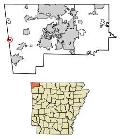
Location of Cherokee City in Benton County, Arkansas.
USA Arkansas location map.svg
Red pog.svg
Cherokee City, Arkansas
Coordinates: 36°17′54″N94°34′40″W / 36.29833°N 94.57778°W / 36.29833; -94.57778
Country United States
State Arkansas
County Benton
Area
[1]
  Total0.47 sq mi (1.21 km2)
  Land0.47 sq mi (1.21 km2)
  Water0.00 sq mi (0.00 km2)
Elevation
[2]
1,155 ft (352 m)
Population
 (2020)
  Total73
  Density155.98/sq mi (60.17/km2)
Time zone UTC-6 (Central (CST))
  Summer (DST) UTC-5 (CDT)
Area code 479
GNIS feature ID76597 [2]

Cherokee City is an unincorporated census-designated place (CDP) in Benton County, Arkansas, United States. Per the 2020 census, the population was 73. [3] It is the location of (or is the nearest community to) Coon Creek Bridge, which is located on Cty Rd. 24 and is listed on the National Register of Historic Places. [4] The community was named for the Cherokee, since the Trail of Tears crossed the landscape when the Cherokee migrated west to Indian territory, now Oklahoma in the late 1830s. The town is within the Northwest Arkansas region, located about 5 miles east of Oklahoma and 4 miles south of the Missouri state line.

Contents

Demographics

Historical population
CensusPop.Note
2010 72
2020 731.4%
U.S. Decennial Census [5]
2010 [6] 2020 [7]

2020 census

Cherokee City CDP, Arkansas – Demographic Profile
(NH = Non-Hispanic)
Note: the US Census treats Hispanic/Latino as an ethnic category. This table excludes Latinos from the racial categories and assigns them to a separate category. Hispanics/Latinos may be of any race.
Race / EthnicityPop 2010 [6] Pop 2020 [7] % 2010% 2020
White alone (NH)645188.89%69.86%
Black or African American alone (NH)020.00%2.74%
Native American or Alaska Native alone (NH)425.56%2.74%
Asian alone (NH)030.00%4.11%
Pacific Islander alone (NH)000.00%0.00%
Some Other Race alone (NH)000.00%0.00%
Mixed Race/Multi-Racial (NH)2102.78%13.70%
Hispanic or Latino (any race)252.78%6.85%
Total7273100.00%100.00%

History

Cherokee City was platted in 1880. [8] A post office called Cherokee City was established in 1871, and remained in operation until 1953. [9]

Education

Public education is available from the Gentry School District, [10] that leads to graduation from Gentry High School.

Related Research Articles

<span class="mw-page-title-main">Prairie Creek, Arkansas</span> CDP in Arkansas, United States

Prairie Creek is a census-designated place (CDP) in Benton County, Arkansas, United States. Per the 2020 census, the population was 2,217. It is a lakefront community adjacent to Beaver Lake and Rogers within the Northwest Arkansas region.

<span class="mw-page-title-main">Salem, Saline County, Arkansas</span> CDP in Arkansas, United States

Salem is a census-designated place (CDP) in Saline County, Arkansas, United States. Per the 2020 census, the population was 2,544. It is part of the Little Rock–North Little Rock–Conway Metropolitan Statistical Area.

<span class="mw-page-title-main">Benton Heights, Michigan</span> Census-designated place & unincorporated community in Michigan, United States

Benton Heights is an unincorporated community in Berrien County in the U.S. state of Michigan. It is also a census-designated place (CDP) for statistical purposes without any legal status as an incorporated municipality. Per the 2020 Census, the population was 3,652. The community is a part of Benton Charter Township and is adjacent to the city of Benton Harbor.

Dora is an unincorporated community and census-designated place (CDP) in Crawford County in the western part of the U.S. state of Arkansas. It is located approximately three miles west of Van Buren on the Arkansas-Oklahoma border along Interstate 40. The community is part of the Fort Smith, Arkansas-Oklahoma Metropolitan Statistical Area. Dora shares its ZIP code (72956) and other municipal services with Van Buren.

<span class="mw-page-title-main">Atlantic, Virginia</span> Census-designated place in Virginia, United States

Atlantic is a census-designated place (CDP) in Accomack County, Virginia. It was first listed as a CDP in 2010. Per the 2020 census, the population was 808.

<span class="mw-page-title-main">Roland, Arkansas</span> Census-designated place in Arkansas, United States

Roland is a census-designated place in Pulaski County, Arkansas, United States. It is part of the Central Arkansas metropolitan area. Per the 2020 census, the population was 820.

<span class="mw-page-title-main">Maysville, Arkansas</span> Census-designated place in Arkansas, United States

Maysville is an unincorporated community and census-designated place (CDP) in Benton County, Arkansas, United States. It is the westernmost settlement in the state of Arkansas. Per the 2020 census, the population was 117. It is located in the Northwest Arkansas region.

Salado is an Incorporated community and census-designated place (CDP) in Independence County, Arkansas, United States. It was first listed as a CDP in the 2020 census with a population of 472.

Midway is a census-designated place in Baxter County, Arkansas, United States. Midway is 5.5 miles (8.9 km) northwest of Mountain Home. Per the 2020 census, the population was 1,036. Midway has a post office with ZIP code 72651. Long home to a rural trading post, Midway became a boomtown during the construction of the Bull Shoals Dam, and later evolved to serve tourists and retirees attracted to the lake.

<span class="mw-page-title-main">Kingston, Arkansas</span> Census-designated place in Arkansas, United States

Kingston is an unincorporated community and census-designated place (CDP) in northeast Madison County, Arkansas, United States. It was first listed as a CDP in the 2020 census with a population of 97.

<span class="mw-page-title-main">Uniontown, Arkansas</span> Census-designated place in Arkansas, United States

Uniontown is an unincorporated community and census-designated place (CDP) in Crawford County, Arkansas, United States. It is located on Arkansas Highway 220 near the Oklahoma border, 4.5 miles (7.2 km) west-northwest of Cedarville. Uniontown has a post office with ZIP code 72955.

<span class="mw-page-title-main">Evansville, Arkansas</span> Census-designated place in Arkansas, United States

Evansville is an unincorporated community and census-designated place (CDP) in southwest Washington County, Arkansas, United States. It was first listed as a CDP in the 2020 census with a population of 102.

<span class="mw-page-title-main">Avilla, Arkansas</span> Census-designated place in Arkansas, United States

Avilla is a census-designated place in Saline County, Arkansas, United States. Per the 2020 census, the population was 1,325.

<span class="mw-page-title-main">Hagarville, Arkansas</span> Census-designated place in Arkansas, United States

Hagarville is a census-designated place in Johnson County, Arkansas, United States. Per the 2020 census, the population was 142.

Alleene is an unincorporated community and census-designated place (CDP) in Little River County, Arkansas, United States. It was first listed as a CDP in the 2020 census with a population of 97.

<span class="mw-page-title-main">Lost Bridge Village, Arkansas</span> Census-designated place in Arkansas, United States

Lost Bridge Village is a residential subdivision near the town of Garfield in Benton County, Arkansas, United States. Per the 2020 census, the population was 397. It is located in the Northwest Arkansas region.

<span class="mw-page-title-main">Rye, Arkansas</span> Census-designated place in Arkansas, United States

Rye is a census-designated place in Cleveland County, Arkansas, United States. Per the 2020 census, the population was 123.

<span class="mw-page-title-main">Tumbling Shoals, Arkansas</span> Census-designated place in Arkansas, United States

Tumbling Shoals is a census-designated place in Cleburne County, Arkansas, United States. Per the 2020 census, the population was 902.

Woodlawn is a census-designated place in Cleveland County, Arkansas, United States. Per the 2020 census, the population was 174.

Wesley is an unincorporated community and census-designated place (CDP) in western Madison County, Arkansas, United States. Wesley is located at the junction of Arkansas highways 74 and 295, 13 miles (21 km) by road west-southwest of Huntsville. Wesley has a post office with ZIP code 72773. It was first listed as a CDP in the 2020 census with a population of 161.

References

  1. "2020 U.S. Gazetteer Files". United States Census Bureau. Retrieved October 29, 2021.
  2. 1 2 U.S. Geological Survey Geographic Names Information System: Cherokee City, Arkansas
  3. "Cherokee City CDP, Arkansas". United States Census Bureau . Retrieved April 15, 2022.
  4. "National Register Information System". National Register of Historic Places . National Park Service. March 13, 2009.
  5. "Decennial Census of Population and Housing by Decades". US Census Bureau.
  6. 1 2 "P2 HISPANIC OR LATINO, AND NOT HISPANIC OR LATINO BY RACE – 2010: DEC Redistricting Data (PL 94-171) – Cherokee City CDP, Arkansas". United States Census Bureau .
  7. 1 2 "P2 HISPANIC OR LATINO, AND NOT HISPANIC OR LATINO BY RACE – 2020: DEC Redistricting Data (PL 94-171) – Cherokee City CDP, Arkansas". United States Census Bureau .
  8. History of Benton, Washington, Carroll, Madison, Crawford, Franklin, and Sebastian Counties, Arkansas. Higginson Book Company. 1889. p. 104.
  9. "Post Offices". Jim Forte Postal History. Retrieved January 5, 2017.
  10. "2020 CENSUS - SCHOOL DISTRICT REFERENCE MAP: Benton County, AR" (PDF). U.S. Census Bureau . Retrieved May 25, 2022.

36°17′54″N94°34′40″W / 36.29833°N 94.57778°W / 36.29833; -94.57778