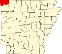
Clear Point, Arkansas

Last updated

Clear Point is an unincorporated community in Benton County, Arkansas, United States. [1]

Related Research Articles

<span class="mw-page-title-main">St Catherine's Point</span>

St Catherine's Point is the southernmost point on the Isle of Wight. It is close to the village of Niton and the point where the Back of the Wight changes to the Undercliff of Ventnor.

Blessings Golf Club is a private, 18-hole golf course located along Clear Creek in Johnson, Arkansas, near Fayetteville. Its creation was funded by Tyson Foods Chairman John H. Tyson. Blessings was designed by Robert Trent Jones, Jr. and opened in June 2004. From the back tees, its rating is 79.1 and its slope is 153, making it one of the toughest golf courses in the U.S. Its routing is a true "out-in" design, in that the 9th hole does not end at the clubhouse. Blessings features three par-5 holes on the "out" nine and three par-3 holes on the "in" nine, for a par of 37-35=72. Its topography is characterized by hilly terrain creating numerous sidehill lies, dramatic elevation changes, forced carries over ravines and valleys, and large, undulating greens, with Clear Creek in play on several holes.

<span class="mw-page-title-main">Arkansas's 3rd congressional district</span> U.S. House district for Arkansas

Arkansas's 3rd congressional district is a congressional district in the U.S. state of Arkansas. The district covers Northwest Arkansas and takes in Fort Smith, Fayetteville, Springdale, and Bentonville.

KKIX is a radio station in Fayetteville, Arkansas with a country music format. The station is owned and operated by iHeartMedia. The station was previously home to KNWA Radio.

KIGL, known as "93.3 The Eagle", is a classic rock radio station licensed to Seligman, Missouri but based in Fayetteville, Arkansas. KIGL is owned by iHeartMedia, Inc. KIGL serves the Northwest Arkansas, extreme Southwest Missouri, and extreme Northeast Oklahoma region with an ERP of 100,000 watts.

The four-state area or quad-state area is where the states of Arkansas, Kansas, Missouri, and Oklahoma almost touch: Arkansas and Kansas share no boundary. The metropolitan areas of Tulsa, Oklahoma; Joplin, Missouri; and Fayetteville–Springdale–Rogers, Arkansas are in the region. Notable cities and towns in the area are Tulsa and Miami, Oklahoma; Pittsburg, Kansas; Joplin, Springfield, and Monett, Missouri; and Fayetteville, Springdale, Rogers, and Bentonville, Arkansas.

<span class="mw-page-title-main">KFAY</span> Radio station in Farmington, Arkansas

KFAY is a radio station serving the Fayetteville, Arkansas, area with a news/talk format. It is under ownership of Cumulus Media. The station's frequency, 1030 AM, is a United States clear-channel frequency, on which WBZ in Boston is the dominant Class A station.

<span class="mw-page-title-main">Bluie</span> WWII United States military code name for Greenland

Bluie was the United States military code name for Greenland during World War II. It is remembered by the numbered sequence of base locations identified by the 1941 United States Coast Guard South Greenland Survey Expedition, and subsequently used in radio communications by airmen unfamiliar with pronunciation of the Greenlandic Inuit and Danish names of those locations. These were typically spoken BLUIE (direction) (number), with direction being east or west along the Greenland coast from Cape Farewell.

Milligan College is an unincorporated community and an area of Elizabethton, in Carter County, Tennessee. Milligan is home to Milligan University and Emmanuel Christian Seminary. All of Milligan has been annexed by the city of Elizabethton.

Beaty is an unincorporated community in Benton County, Arkansas, United States. It is approximately 4.5 miles northwest of Gravette and 3.2 miles south of the Arkansas-Missouri state line.

Beaver Shores is an unincorporated community in Benton County, Arkansas, United States.

Bloomfield is an unincorporated community in Benton County, Arkansas, United States.

Cross Hollow is an unincorporated community in Benton County, Arkansas, United States.

Dawn Hill is an unincorporated community in Benton County, Arkansas, United States.

Wedington Township is an inactive township in Washington County, Arkansas, United States.

McGuire is an extinct town in Washington County, in the U.S. state of Arkansas. The community is located southeast of Fayetteville on Arkansas Highway 74. The White River flows past the southwest side of the community.

Weddington is an unincorporated community in Washington County, in the U.S. state of Arkansas.

Wheeler is an unincorporated community in Washington County, in the U.S. state of Arkansas. The community is approximately four miles northwest of Fayetteville and lies adjacent to the Clear Creek floodplain.

Soğuksu Creek is a creek in Mersin Province, Turkey. It is a short creek formed by merging two small streams just north of Aydıncık ilçe (district). Like most other creeks in the province its flow rate fluctuates during the year. But even in the hottest season it doesn't dry up. It discharges to Mediterranean Sea at 36°08′07″N33°17′44″E.

References

36°17′44″N94°00′38″W / 36.29556°N 94.01056°W / 36.29556; -94.01056