Prairie Creek, Arkansas

Last updated

Prairie Creek, Arkansas
CDP
View of Beaver Lake from Prairie Creek, Arkansas.jpg
View of Beaver Lake from Prairie Creek, Arkansas
Benton County Arkansas Incorporated and Unincorporated areas Prairie Creek Highlighted.svg
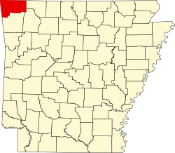
Location in Benton County and the state of Arkansas
Coordinates: 36°20′27″N94°3′42″W / 36.34083°N 94.06167°W / 36.34083; -94.06167
Country United States
State Arkansas
County Benton
Area
[1]
  Total4.87 sq mi (12.60 km2)
  Land4.37 sq mi (11.32 km2)
  Water0.49 sq mi (1.28 km2)
Elevation
[2]
1,404 ft (428 m)
Population
 (2020)
  Total2,217
  Density507.09/sq mi (195.81/km2)
Time zone UTC-6 (Central (CST))
  Summer (DST) UTC-5 (CDT)
ZIP code
72756 [3]
Area code 479
FIPS code 05-57125
GNIS feature ID0058424 [2]

Prairie Creek is a census-designated place (CDP) in Benton County, Arkansas, United States. Per the 2020 census, the population was 2,217. [4] It is a lakefront community adjacent to Beaver Lake and Rogers within the Northwest Arkansas region.

Contents

Geography

Prairie Creek is located at 36°20′27″N94°3′42″W / 36.34083°N 94.06167°W / 36.34083; -94.06167 (36.340915, -94.061603). [5]

According to the United States Census Bureau, the CDP has a total area of 4.4 square miles (11 km2), all land.

Demographics

Historical population
CensusPop.Note
2000 1,849
2010 2,06611.7%
2020 2,2177.3%
U.S. Decennial Census [6]
2010 [7] 2020 [8]

2020 census

Prairie Creek CDP, Arkansas – Demographic Profile
(NH = Non-Hispanic)
Note: the US Census treats Hispanic/Latino as an ethnic category. This table excludes Latinos from the racial categories and assigns them to a separate category. Hispanics/Latinos may be of any race.
Race / EthnicityPop 2010 [7] Pop 2020 [8] % 2010% 2020
White alone (NH)1,9321,88993.51%85.21%
Black or African American alone (NH)1060.48%0.27%
Native American or Alaska Native alone (NH)27141.31%0.63%
Asian alone (NH)26161.26%0.72%
Pacific Islander alone (NH)1110.05%0.50%
Some Other Race alone (NH)260.10%0.27%
Mixed Race/Multi-Racial (NH)261111.26%5.01%
Hispanic or Latino (any race)421642.03%7.40%
Total2,0662,217100.00%100.00%

2000 Census

As of the census [9] of 2000, there were 1,849 people, 832 households, and 607 families residing in the CDP. The population density was 432.3 inhabitants per square mile (166.9/km2). There were 914 housing units at an average density of 213.7 per square mile (82.5/km2). The racial makeup of the CDP was 97.35% White, 0.16% Black or African American, 0.92% Native American, 0.22% Asian, 0.11% Pacific Islander, 0.22% from other races, and 1.03% from two or more races. 0.92% of the population were Hispanic or Latino of any race.

There were 832 households, out of which 18.4% had children under the age of 18 living with them, 67.2% were married couples living together, 3.1% had a female householder with no husband present, and 27.0% were non-families. 22.8% of all households were made up of individuals, and 10.3% had someone living alone who was 65 years of age or older. The average household size was 2.22 and the average family size was 2.59.

In the CDP, the population was spread out, with 17.1% under the age of 18, 3.5% from 18 to 24, 20.3% from 25 to 44, 32.2% from 45 to 64, and 26.9% who were 65 years of age or older. The median age was 51 years. For every 100 females, there were 94.6 males. For every 100 females age 18 and over, there were 92.1 males.

The median income for a household in the CDP was $59,000, and the median income for a family was $61,709. Males had a median income of $52,969 versus $30,852 for females. The per capita income for the CDP was $37,355. About 2.3% of families and 4.5% of the population were below the poverty line, including 8.1% of those under age 18 and 3.5% of those age 65 or over.

Human resources

Public education for early childhood, elementary and secondary school students is provided by Rogers School District.

The primary law enforcement agency in Prairie Creek is the Benton County Sheriff's Office. The Prairie Creek Substation opened on Highway 12 in 2017. [10]

Culture

Prairie Creek Marina, Prairie Creek Park on Beaver Lake. Prairie Creek, Arkansas. Prairie Creek Marina, Beaver Lake Arkansas.JPG
Prairie Creek Marina, Prairie Creek Park on Beaver Lake. Prairie Creek, Arkansas.

The community is home to the Prairie Creek Marina on Beaver Lake. The marina has over 500 boat slips. [11]

Education

It is in the Rogers Public Schools school district. [12]

Related Research Articles

<span class="mw-page-title-main">Benton County, Arkansas</span> County in Arkansas, United States

Benton County is a county within the Northwest Arkansas region with a culture, economy, and history that have transitioned from rural and agricultural to suburban and white collar since the growth of Walmart, which is headquartered in Benton County. Created as Arkansas's 35th county on September 30, 1836, Benton County contains thirteen incorporated municipalities, including Bentonville, the county seat, and Rogers, the most populous city. The county was named after Thomas Hart Benton, a U.S. Senator from Missouri influential in Arkansas statehood.

<span class="mw-page-title-main">Rock Creek, Alabama</span> CDP in Alabama, United States

Rock Creek is a census-designated place in Jefferson County, Alabama, United States. Its location is northwest of Hueytown. At the 2020 census, the population was 1,471. This area was damaged by an F5 tornado on April 8, 1998. An EF2 tornado struck northwest from here on January 23, 2012.

<span class="mw-page-title-main">North Crossett, Arkansas</span> CDP in Arkansas, United States

North Crossett is a census-designated place (CDP) in Ashley County, Arkansas, United States. Per the 2020 census, the population was 2,756.

<span class="mw-page-title-main">West Crossett, Arkansas</span> CDP in Arkansas, United States

West Crossett is a census-designated place (CDP) in Ashley County, Arkansas, United States. Per the 2020 census, the population was 1,144.

<span class="mw-page-title-main">Avoca, Arkansas</span> Town in Arkansas, United States

Avoca is a town in Benton County, Arkansas, United States. The population was 487 at the 2020 census. It is part of the Northwest Arkansas region.

<span class="mw-page-title-main">Bethel Heights, Arkansas</span> City in Arkansas, United States

Bethel Heights was a city in Benton County, Arkansas, United States. Always a small, sparsely populated community, the region coalesced around a school named Bethel in the late 19th century but did not incorporate until 1967 to avoid annexation by larger neighboring communities. The town offered police and fire protection and wastewater service to residents, but sent students to Springdale Public Schools and purchased water from Springdale Water Utilities. By the 21st century, Northwest Arkansas was gaining population rapidly, and Bethel Heights reincorporated as a city and grew from a population of 714 in 2000 to 2,372 at the 2010 census. Growth put pressure on the city's subsurface discharge wastewater treatment system, and following a series of wastewater treatment plant violations, voters dissolved the city and completely annexed into Springdale in August 2020.

<span class="mw-page-title-main">Decatur, Arkansas</span> City in Arkansas, United States

Decatur is a city, in Benton County, Arkansas, United States. The population was 1,773 at the 2020 census. It is part of the Northwest Arkansas region. This town is named after Commodore Stephen Decatur, Jr.

<span class="mw-page-title-main">Little Flock, Arkansas</span> City in Arkansas, United States

Little Flock is a city in Benton County, Arkansas, United States. The population was 3,055 at the 2020 census. It is part of the Northwest Arkansas region.

<span class="mw-page-title-main">Lowell, Arkansas</span> City in Arkansas, United States

Lowell is a city in Benton County, Arkansas, United States. Located within the Ozarks, the first settlement was along Old Wire Road in the 1840s, and although destroyed during the Civil War, the community was reestablished by J. R. McClure and thrived when the St. Louis–San Francisco Railway came through the area in the 1880s. The city is a growing bedroom community within the rapidly growing Northwest Arkansas region. Lowell is the headquarters of trucking company J.B. Hunt. Lowell's population was 9,839 at the 2020 census, an increase of 34% since 2010.

<span class="mw-page-title-main">Springtown, Arkansas</span> Town in Arkansas, United States

Springtown is a town in Benton County, Arkansas, United States. The population was 83 at the 2020 census. It is part of the Northwest Arkansas region.

<span class="mw-page-title-main">Anthonyville, Arkansas</span> Town in Arkansas, United States

Anthonyville is a town in Crittenden County, Arkansas, United States. The population was 161 at the 2010 census, down from 250 in 2000.

<span class="mw-page-title-main">Reader, Arkansas</span> Census-designated place in Arkansas, United States

Reader is an unincorporated census-designated place in Nevada and Ouachita counties in the U.S. state of Arkansas. As of the 2010 census, its population is 66. Per the 2020 census, the population was 40.

<span class="mw-page-title-main">Hensley, Arkansas</span> Census-designated place in Arkansas, United States

Hensley is a census-designated place (CDP) in Pulaski County, Arkansas, United States. The population was 139 at the 2010 census. It is part of the Little Rock–North Little Rock–Conway Metropolitan Statistical Area.

<span class="mw-page-title-main">Landmark, Arkansas</span> CDP in Arkansas, United States

Landmark is a census-designated place (CDP) in Pulaski County, Arkansas, United States. Per the 2020 census, the population was 3,585. It is part of the Little Rock–North Little Rock–Conway Metropolitan Statistical Area.

<span class="mw-page-title-main">Salem, Saline County, Arkansas</span> CDP in Arkansas, United States

Salem is a census-designated place (CDP) in Saline County, Arkansas, United States. Per the 2020 census, the population was 2,544. It is part of the Little Rock–North Little Rock–Conway Metropolitan Statistical Area.

<span class="mw-page-title-main">Sunset, Florida</span> Census-designated place in Florida

Sunset is a census-designated place (CDP) in Miami-Dade County, Florida, United States. It is part of the Miami metropolitan area of South Florida. The population was 15,912 at the 2020 census. The U.S. Postal Service uses the ZIP Codes of 33173 and 33183 for Sunset.

Limestone Creek is a census-designated place (CDP) in Palm Beach County, Florida, United States. It is part of the Miami metropolitan area of South Florida. The population was 1,316 at the 2020 US census.

<span class="mw-page-title-main">Fruit Cove, Florida</span> CDP in Florida, United States

Fruit Cove is a census-designated place (CDP) in St. Johns County, Florida, United States. It is located in the community of St. Johns. The population was 32,143 at the 2020 census.

<span class="mw-page-title-main">Benton Heights, Michigan</span> Census-designated place & unincorporated community in Michigan, United States

Benton Heights is an unincorporated community in Berrien County in the U.S. state of Michigan. It is also a census-designated place (CDP) for statistical purposes without any legal status as an incorporated municipality. Per the 2020 Census, the population was 3,652. The community is a part of Benton Charter Township and is adjacent to the city of Benton Harbor.

<span class="mw-page-title-main">Alafaya, Florida</span> Census-designated place in Florida, United States

Alafaya is a census-designated place and unincorporated area in Orange County, Florida, United States. The population was 92,452 at the 2020 US census. It is part of the Orlando–Kissimmee–Sanford, Florida Metropolitan Statistical Area. It is most known for being near the University of Central Florida, Avalon Park and Waterford Lakes.

References

  1. "2020 U.S. Gazetteer Files". United States Census Bureau. Retrieved October 29, 2021.
  2. 1 2 U.S. Geological Survey Geographic Names Information System: Prairie Creek, Arkansas
  3. "Prairie Creek AR ZIP Code". zipdatamaps.com. 2023. Retrieved January 26, 2023.
  4. "Prairie Creek CDP, Arkansas". United States Census Bureau . Retrieved April 15, 2022.
  5. "US Gazetteer files: 2010, 2000, and 1990". United States Census Bureau. February 12, 2011. Retrieved April 23, 2011.
  6. "Decennial Census of Population and Housing by Decades". US Census Bureau.
  7. 1 2 "P2 HISPANIC OR LATINO, AND NOT HISPANIC OR LATINO BY RACE – 2010: DEC Redistricting Data (PL 94-171) – Prairie Creek CDP, Arkansas". United States Census Bureau .
  8. 1 2 "P2 HISPANIC OR LATINO, AND NOT HISPANIC OR LATINO BY RACE – 2020: DEC Redistricting Data (PL 94-171) – Prairie Creek CDP, Arkansas". United States Census Bureau .
  9. "U.S. Census website". United States Census Bureau . Retrieved January 31, 2008.
  10. Eley, Ashton (June 23, 2017). "Benton County Sheriff's Office opens Prairie Creek substation". Northwest Arkansas Democrat Gazette . WEHCO Media . Retrieved May 11, 2020.
  11. Gergeni, Matt (September 30, 2003). "Prairie Creek Marina adds 124 new boat-rental slips". Benton County Daily Record . WEHCO Media. p. 2. Retrieved May 11, 2020 via Newsbank.
  12. "2020 CENSUS - SCHOOL DISTRICT REFERENCE MAP: Benton County, AR" (PDF). U.S. Census Bureau . Retrieved May 25, 2022.