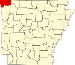
Highfill, Arkansas

Last updated

Highfill, Arkansas
Highfill City Hall.jpg
City Hall
Benton County Arkansas Incorporated and Unincorporated areas Highfill Highlighted 0532200.svg
Location of Highfill in Benton County, Arkansas.
Coordinates: 36°16′14″N94°19′30″W / 36.27056°N 94.32500°W / 36.27056; -94.32500
Country United States
State Arkansas
County Benton
Area
[1]
  Total18.13 sq mi (46.94 km2)
  Land18.02 sq mi (46.68 km2)
  Water0.10 sq mi (0.27 km2)
Elevation
[2]
1,355 ft (413 m)
Population
 (2020)
  Total1,587
  Density88.06/sq mi (34.00/km2)
Time zone UTC-6 (Central (CST))
  Summer (DST) UTC-5 (CDT)
ZIP codes
Area code 479
FIPS code 05-32200
GNIS feature ID0057923 [2]
Website www.highfillar.com

Highfill is a town in Benton County, Arkansas, United States. The population was 1,587 as of the 2020 census. [3] It is home to the Northwest Arkansas National Airport, which serves all of the Northwest Arkansas region. In September 2023, officials of the airport voted to detach itself from the city over taxing and public service disputes. [4]

Contents

Geography

Highfill is located in west-central Benton County at 36°16′14″N94°19′30″W / 36.27056°N 94.32500°W / 36.27056; -94.32500 (36.270483, -94.325093). [5] Arkansas Highway 12 passes through the town, leading northeast to Bentonville and Rogers and west to Gentry. The Northwest Arkansas National Airport occupies the eastern part of town.

According to the United States Census Bureau, Highfill has a total area of 18.3 square miles (47.3 km2), of which 18.2 square miles (47.1 km2) is land and 0.12 square miles (0.3 km2), or 0.58%, is water. [3]

Demographics

Historical population
CensusPop.Note
1960 92
1970 80−13.0%
1980 9215.0%
1990 84−8.7%
2000 379351.2%
2010 58353.8%
2020 1,587172.2%
U.S. Decennial Census [6]

As of the census [7] of 2010, there were 561 people, 191 households, and 153 families residing in the town. The population density was 12.9/km2 (33.5/mi2). There were 165 housing units at an average density of 5.6/km2 (14.6/mi2). The racial makeup of the town was 92.08% White, 5.28% Native American, 1.06% Asian, 1.32% from other races, and 0.26% from two or more races. 1.06% of the population were Hispanic or Latino of any race.

There were 144 households, out of which 32.6% had children under the age of 18 living with them, 61.1% were married couples living together, 11.8% had a female householder with no husband present, and 22.9% were non-families. 19.4% of all households were made up of individuals, and 6.9% had someone living alone who was 65 years of age or older. The average household size was 2.63 and the average family size was 2.90.

In the town, the population was spread out, with 26.4% under the age of 18, 8.4% from 18 to 24, 31.4% from 25 to 44, 22.7% from 45 to 64, and 11.1% who were 65 years of age or older. The median age was 34 years. For every 100 females, there were 100.5 males. For every 100 females age 18 and over, there were 95.1 males.

The median income for a household in the town was $28,854, and the median income for a family was $30,938. Males had a median income of $21,477 versus $21,705 for females. The per capita income for the town was $12,701. About 5.3% of families and 18.6% of the population were below the poverty line, including 21.4% of those under age 18 and 29.2% of those age 65 or over.

Education

The school in Highfill (constructed c. 1911) was consolidated into Gentry in 1948 Highfill Community Building.jpg
The school in Highfill (constructed c.1911) was consolidated into Gentry in 1948

Public education is available from these school districts based on resident's location: [8]

Dispute with XNA Airport

In September 2023, the board of Northwest Arkansas National Airport (XNA) voted to begin the process of detaching itself from the city of Highfill. The vote was unanimous among the board members present for the vote, while two board members were not present and did not vote.

Among the issues causing the dispute was the taxing of transactions at the airport. All airport transactions were subject to a Highfill city sales tax of 2%. Attorneys for the airport maintained that the airport property received no benefit from the city in regard to policing, firefighting, and road maintenance.

According to a new Arkansas law in 2023, the airport would be responsible for paying off city bonds if it chooses to finalize the detachment from the city. [4]

Related Research Articles

<span class="mw-page-title-main">Benton County, Arkansas</span> County in Arkansas, United States

Benton County is a county within the Northwest Arkansas region with a culture, economy, and history that have transitioned from rural and agricultural to suburban and white collar since the growth of Walmart, which is headquartered in Benton County. Created as Arkansas's 35th county on September 30, 1836, Benton County contains thirteen incorporated municipalities, including Bentonville, the county seat, and Rogers, the most populous city. The county was named after Thomas Hart Benton, a U.S. Senator from Missouri influential in Arkansas statehood.

<span class="mw-page-title-main">Avoca, Arkansas</span> Town in Arkansas, United States

Avoca is a town in Benton County, Arkansas, United States. The population was 487 at the 2020 census. It is part of the Northwest Arkansas region.

<span class="mw-page-title-main">Bella Vista, Arkansas</span> City in Arkansas, United States

Bella Vista is a city in Benton County, Arkansas, United States. First established in 1917 as a summer resort destination, Bella Vista has evolved and redesigned itself over the succeeding years. Bella Vista became a retirement community in 1965, and, after much contention and a 2006 vote of its property owners, became an incorporated city.

<span class="mw-page-title-main">Bentonville, Arkansas</span> City in Arkansas, United States

Bentonville is the ninth-most populous city in the US state of Arkansas, and the county seat of Benton County. The city is centrally located in the county with Rogers adjacent to the east. The city is the birthplace and headquarters of Walmart, the world's largest retailer. It is one of the four main cities in the three-county Northwest Arkansas Metropolitan Statistical Area, which is ranked 105th in terms of population in the United States with 546,725 residents in 2020, according to the United States Census Bureau. The city itself had a population of 54,164 at the 2020 Census, an increase of 53% from the 2010 Census. Bentonville is considered to be one of the fastest growing cities in the state and consistently ranks amongst the safest cities in Arkansas.

<span class="mw-page-title-main">Cave Springs, Arkansas</span> City in Arkansas, United States

Cave Springs is a city in Benton County, Arkansas. The population was 5,495 at the time of the 2020 census, up from 1,729 in 2010 census. It is part of the Northwest Arkansas metropolitan area. In June 2022, Cave Springs was named the 3rd highest average home values in the state of Arkansas.

<span class="mw-page-title-main">Centerton, Arkansas</span> City in Arkansas, United States

Centerton is a city in Benton County, Arkansas, United States. Located west of Bentonville on Highway 102, Centerton has grown from a railroad stop and fruit orchard community in the early 20th century into a suburban bedroom community within the rapidly growing Northwest Arkansas (NWA) region. The city's population has grown from 491 in 1990 to 16,244 in 2019. Centerton is considered to be one of the fastest growing cities in Arkansas and consistently ranks amongst the safest cities in the state.

<span class="mw-page-title-main">Decatur, Arkansas</span> City in Arkansas, United States

Decatur is a city, in Benton County, Arkansas, United States. The population was 1,773 at the 2020 census. It is part of the Northwest Arkansas region. This town is named after Commodore Stephen Decatur, Jr.

<span class="mw-page-title-main">Garfield, Arkansas</span> Town in Arkansas, United States

Garfield is a town in Benton County, Arkansas, United States. The population was 593 at the 2020 census. It is part of the Northwest Arkansas region.

<span class="mw-page-title-main">Gateway, Arkansas</span> Town in Arkansas, United States

Gateway is a town in Benton County, Arkansas, United States. The population was 436 at the 2020 census, up from 405 in 2010. It is part of the Northwest Arkansas region. The town's name reflects its situation as the "gateway" to and from Arkansas.

<span class="mw-page-title-main">Gentry, Arkansas</span> City in Arkansas, United States

Gentry is a city in Benton County, Arkansas, United States. The population was 3,790 as of the 2020 census. The city was founded in the Ozark Mountains in 1894 along what would become the Kansas City Southern Railroad. The city's prior prosperity in the orchard industry, especially apples, was further strengthened by the rail connection. Following the decline of the apple industry in the 1930s, Gentry shifted its economy towards poultry along with many other areas of Northwest Arkansas.

<span class="mw-page-title-main">Gravette, Arkansas</span> City in Arkansas, United States

Gravette is a city in Benton County, Arkansas, United States. The population was 3,547 as of the 2020 census. It is part of the Northwest Arkansas region.

<span class="mw-page-title-main">Little Flock, Arkansas</span> City in Arkansas, United States

Little Flock is a city in Benton County, Arkansas, United States. The population was 3,055 at the 2020 census. It is part of the Northwest Arkansas region.

<span class="mw-page-title-main">Lowell, Arkansas</span> City in Arkansas, United States

Lowell is a city in Benton County, Arkansas, United States. Located within the Ozarks, the first settlement was along Old Wire Road in the 1840s, and although destroyed during the Civil War, the community was reestablished by J. R. McClure and thrived when the St. Louis–San Francisco Railway came through the area in the 1880s. The city is a growing bedroom community within the rapidly growing Northwest Arkansas region. Lowell is the headquarters of trucking company J.B. Hunt. Lowell's population was 9,839 at the 2020 census, an increase of 34% since 2010.

<span class="mw-page-title-main">Pea Ridge, Arkansas</span> City in Arkansas

Pea Ridge is a city in Benton County, Arkansas, United States. The name Pea Ridge is derived from a combination of the physical location of the original settlement of the town, across the crest of a ridge of the Ozark Mountains, and for the hog peanuts or turkey peas that had been originally cultivated by Native American tribes centuries before European settlement, which later helped to provide basic subsistence once those pioneer settlers arrived.

<span class="mw-page-title-main">Rogers, Arkansas</span> City in the United States

Rogers is a city in Benton County, Arkansas, United States. Located in the Ozarks, it is part of the Northwest Arkansas region, one of the fastest growing metro areas in the country. Rogers was the location of the first Walmart store, whose corporate headquarters is located in neighboring Bentonville. Daisy Outdoor Products, known for its air rifles, has both its headquarters and its Airgun Museum in Rogers. The city houses a popular shopping center, the Pinnacle Hills Promenade, and a music venue, the Walmart AMP, that has housed performances by big-name artists and local performers alike.

<span class="mw-page-title-main">Siloam Springs, Arkansas</span> City in Arkansas, United States

Siloam Springs is a city in Benton County, Arkansas, United States, and located on the western edge of the Northwest Arkansas metropolitan area. As of the 2020 census, the population of the city was 17,287. The community was founded in 1882 and was characterized by the purported healing powers of the spring water feeding Sager Creek and trading with nearby Native American tribes. The city shares a border on the Arkansas–Oklahoma state line with the city of West Siloam Springs, Oklahoma, which is within the Cherokee Nation territory. It is home of John Brown University.

<span class="mw-page-title-main">Springtown, Arkansas</span> Town in Arkansas, United States

Springtown is a town in Benton County, Arkansas, United States. The population was 83 at the 2020 census. It is part of the Northwest Arkansas region.

<span class="mw-page-title-main">Huntsville, Arkansas</span> City in Arkansas, United States

Huntsville is a city in and the county seat of Madison County, Arkansas, United States. The population was 2,879 at the 2020 census, up from 2,346 in 2010. During the American Civil War in 1862, it was the site of what became known as the Huntsville Massacre. Huntsville is part of the Northwest Arkansas region.

<span class="mw-page-title-main">Johnson, Arkansas</span> City in Arkansas, United States

Johnson is a city in Washington County, Arkansas, United States. The community is located in the Ozark Mountains and is surrounded by valleys and natural springs. Early settlers took advantage of these natural features and formed an economy based on mining lime, the Johnson Mill and trout. Although a post office was opened in the community in 1887, Johnson did not incorporate until it required the development of a city government to provide utility services in 1961. Located between Fayetteville and Springdale in the heart of the rapidly growing Northwest Arkansas metropolitan statistical area, Johnson has been experiencing a population and building boom in recent years, as indicated by a 46% growth in population between the 2000 and 2010 censuses.

<span class="mw-page-title-main">Northwest Arkansas</span> Metropolitan area in Arkansas, United States

Northwest Arkansas (NWA) is a metropolitan area and region in Arkansas within the Ozark Mountains. It includes four of the ten largest cities in the state: Fayetteville, Springdale, Rogers, and Bentonville, the surrounding towns of Benton and Washington counties, and adjacent rural Madison County, Arkansas. The United States Census Bureau-defined Fayetteville–Springdale–Rogers Metropolitan Statistical Area includes 3,213.01 square miles (8,321.7 km2) and 576,403 residents, ranking NWA as the 98th most-populous metropolitan statistical area in the U.S. and the 13th fastest growing in the United States.

References

  1. "2020 U.S. Gazetteer Files". United States Census Bureau. Retrieved October 29, 2021.
  2. 1 2 U.S. Geological Survey Geographic Names Information System: Highfill, Arkansas
  3. 1 2 "Geographic Identifiers: 2010 Demographic Profile Data (G001): Highfill town, Arkansas". U.S. Census Bureau, American Factfinder. Archived from the original on February 12, 2020. Retrieved September 24, 2013.
  4. 1 2 https://www.arkansasonline.com/news/2023/sep/19/northwest-arkansas-national-airport-seeks-to-fly/
  5. "US Gazetteer files: 2010, 2000, and 1990". United States Census Bureau. February 12, 2011. Retrieved April 23, 2011.
  6. "Census of Population and Housing". Census.gov. Retrieved June 4, 2015.
  7. "U.S. Census website". United States Census Bureau . Retrieved January 31, 2008.
  8. "2020 CENSUS - SCHOOL DISTRICT REFERENCE MAP: Benton County, AR" (PDF). U.S. Census Bureau . Retrieved May 25, 2022.
  9. "22/23 Elementary Attendance Areas" (PDF). Bentonville School District . Retrieved September 18, 2022. - Linked from here
  10. "22/23 Middle School Attendance Areas" (PDF). Bentonville School District . Retrieved September 18, 2022. - Linked from here
  11. "22/23 Junior High School Attendance Areas" (PDF). Bentonville School District . Retrieved September 18, 2022. - Linked from here
  12. "22/23 High School Attendance Areas" (PDF). Bentonville School District . Retrieved September 18, 2022. - Linked from here