Hiwasse, Arkansas

Last updated

Hiwasse, Arkansas
USA Arkansas location map.svg
Red pog.svg
Hiwasse, Arkansas
Coordinates: 36°25′54″N94°20′02″W / 36.43167°N 94.33389°W / 36.43167; -94.33389
Country United States
State Arkansas
County Benton
Area
[1]
  Total4.943 sq mi (12.80 km2)
  Land4.942 sq mi (12.80 km2)
  Water0.001 sq mi (0.003 km2)
Elevation
[2]
1,332 ft (406 m)
Population
 (2010) [3]
  Total497
  Density100/sq mi (39/km2)
Time zone UTC-6 (Central (CST))
  Summer (DST) UTC-5 (CDT)
ZIP code
72739 [4]
Area code 479
GNIS feature ID77191 [2]

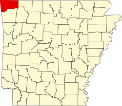
Hiwasse was an unincorporated community and census-designated place in Benton County, Arkansas, United States. As of the 2010 census, its population was 497. [3] It is the location of (or is the nearest community to) Hiwasse Bank Building, which is located at Main St., AR 279 and Banks House, which is located on AR 72 west of Hiwasse. Both are listed on the National Register of Historic Places. [5]

Hiwasse faced a great division in 2007–2008, when two groups faced off over the incorporation of Hiwasse. In the end, the voters decided not to incorporate, with adjacent Gravette annexing the community in 2012.

Education

Public education for elementary and secondary students is provided by Gravette School District, which leads to graduation from Gravette High School.

Related Research Articles

<span class="mw-page-title-main">Benton County, Arkansas</span> County in Arkansas, United States

Benton County is a county in the Northwest region of the U.S. state of Arkansas. Created as Arkansas' 35th county on September 30, 1836, Benton County contains thirteen incorporated municipalities, including Bentonville, the county seat, and Rogers, the most populous city. The county was named after Thomas Hart Benton, a U.S. Senator from Missouri influential in Arkansas statehood.

<span class="mw-page-title-main">Bella Vista, Arkansas</span> City in Arkansas, United States

Bella Vista is a city in Benton County, Arkansas, United States. First established in 1917 as a summer resort destination, Bella Vista has evolved and redesigned itself over the succeeding years. Bella Vista became a retirement community in 1965, and, after much contention and a 2006 vote of its property owners, became an incorporated city.

<span class="mw-page-title-main">Decatur, Arkansas</span> City in Arkansas, United States

Decatur is a city, in Benton County, Arkansas, United States. The population was 1,773 at the 2020 census. It is part of the Northwest Arkansas region. This town is named after Commodore Stephen Decatur, Jr.

<span class="mw-page-title-main">Gravette, Arkansas</span> City in Arkansas, United States

Gravette is a city in Benton County, Arkansas, United States. The population was 3,547 as of the 2020 census. It is part of the Northwest Arkansas region.

<span class="mw-page-title-main">Scott, Arkansas</span> Census-designated place in Arkansas, United States

Scott is an unincorporated community and census-designated place (CDP) in Lonoke and Pulaski counties in the central part of the U.S. state of Arkansas. Per the 2020 census, the population was 97. It is part of the Little Rock–North Little Rock–Conway Metropolitan Statistical Area.

<span class="mw-page-title-main">Bentonville High School</span> Public school in Bentonville, Arkansas, United States

Bentonville High School (BHS) is a public high school in Bentonville, Arkansas, United States. Founded in 1910, the school provides education for students in grades nine through twelve. It is one of two high schools of the Bentonville School District.

<span class="mw-page-title-main">Arkansas Highway 72</span> State highway in Arkansas, United States

Highway 72 is a designation for two east–west state highways in Benton County, Arkansas. A western route of 26.32 miles (42.36 km) runs east from Highway 43 at Maysville to U.S. Route 71B (US 71B) in Bentonville. A second route of 12.67 miles (20.39 km) begins at Interstate 49/US Route 71 (I-49/US 71) in Bentonville and runs northeast to US 62 near Avoca. The route is one of the original Arkansas state highways.

Magnet Cove is a census-designated place (CDP) and former town in Hot Spring County, Arkansas, United States. It is located in the Ouachita Mountains southeast of Hot Springs, on Arkansas Highway 51 north of U.S. Highway 270. As of the 2020 census, the town of Magnet Cove had a population of 692.

<span class="mw-page-title-main">Canehill, Arkansas</span> Unincorporated community in Arkansas

Canehill, also known as Cane Hill and Boonsboro, is an unincorporated community and census-designated place (CDP) in Washington County, Arkansas, United States. It was first listed as a CDP in the 2020 census with a population of 74.

Crocketts Bluff is an unincorporated community in Arkansas County, Arkansas, United States. It is the location of Crocketts Bluff Hunting Lodge, which is located at the end of the dirt road north of the point at which AR 153 turns south, and is listed on the National Register of Historic Places. Crocketts Bluff sits at an elevation of 171 feet the highest point in Arkansas County. The ZIP Code for Crocketts Bluff is 72038.

<span class="mw-page-title-main">Cherokee City, Arkansas</span> Census-designated place in Arkansas, United States

Cherokee City is an unincorporated census-designated place (CDP) in Benton County, Arkansas, United States. Per the 2020 census, the population was 73. It is the location of Coon Creek Bridge, which is located on Cty Rd. 24 and is listed on the National Register of Historic Places. The community was named for the Cherokee, since the Trail of Tears crossed the landscape when the Cherokee migrated west to Indian territory, now Oklahoma in the late 1830s. The town is within the Northwest Arkansas region, located about 5 miles east of Oklahoma and 4 miles south of the Missouri state line.

<span class="mw-page-title-main">Maysville, Arkansas</span> Census-designated place in Arkansas, United States

Maysville is an unincorporated community and census-designated place (CDP) in Benton County, Arkansas, United States. It is the westernmost settlement in the state of Arkansas. Per the 2020 census, the population was 117. It is located in the Northwest Arkansas region.

<span class="mw-page-title-main">New Edinburg, Arkansas</span> Census-designated place in Arkansas, United States

New Edinburg is an unincorporated census-designated place in Cleveland County, Arkansas, United States. Per the 2020 census, the population was 134.

<span class="mw-page-title-main">Old High Middle School (Bentonville, Arkansas)</span> United States historic place

Old High Middle School is a public middle school in Bentonville, Arkansas, part of the Bentonville Public Schools. Its building was once home to Bentonville High School. It was designed by John Parks Almand. It combines Spanish Colonial, Mission, and Mediterranean styles. Construction costs during building in 1928 were $25,000.

<span class="mw-page-title-main">New Blaine, Arkansas</span> Census-designated place in Arkansas, United States

New Blaine is an unincorporated community and census-designated place (CDP) in Logan County, Arkansas, United States. Per the 2020 census, the population was 173.

Princeton is a small unincorporated rural village in Princeton Township, Dallas County, Arkansas, United States, located at the junction of Arkansas highways 8 and 9, 7.5 miles (12.1 km) southwest of Carthage. Princeton Cemetery, which is listed on the National Register of Historic Places, is located in the community. It was first listed as a CDP in the 2020 census with a population of 13.

Township 11 is one of thirteen current townships in Benton County, Arkansas, USA. As of the 2010 census, its total population was 12,273.

Gravette High School is a comprehensive public high school located in the fringe town of Gravette, Arkansas, United States. The school provides secondary education for students in grades 8 through 12. It is one of nine public high schools in Benton County, Arkansas and the sole high school administered by the Gravette School District.

Springhill is an unincorporated community in Faulkner County, Arkansas, United States. The community is located at the junction of U.S. Route 65 and Arkansas Highway 287, 3 miles (4.8 km) south of Greenbrier.

Aplin is an unincorporated rural village in Perry County, Arkansas, United States. The community is located along Arkansas Highway 60, 10.3 miles (16.6 km) west-southwest of Perryville. In addition to several homes, there is a hearth manufactury located at Aplin, and a church. The Camp House, which is listed on the National Register of Historic Places, is near the community.

References

  1. "US Gazetteer files: 2010, 2000, and 1990". United States Census Bureau. February 12, 2011. Retrieved April 23, 2011.
  2. 1 2 U.S. Geological Survey Geographic Names Information System: Hiwasse, Arkansas
  3. 1 2 "U.S. Census website". U.S. Census Bureau . Retrieved May 3, 2011.
  4. "Hiwasse ZIP Code". zipdatamaps.com. 2022. Retrieved November 11, 2022.
  5. "National Register Information System". National Register of Historic Places . National Park Service. March 13, 2009.