Township 9, Benton County, Arkansas

Last updated
Township 9
Township
USA Arkansas location map.svg
Red pog.svg
Township 9
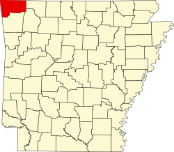
Location in Arkansas
Coordinates: 36°21′16″N94°16′10″W / 36.35444°N 94.26944°W / 36.35444; -94.26944 Coordinates: 36°21′16″N94°16′10″W / 36.35444°N 94.26944°W / 36.35444; -94.26944
Country Flag of the United States.svg  United States
State Flag of Arkansas.svg  Arkansas
County Benton
Area
  Total 49.497 sq mi (128.20 km2)
  Land 49.143 sq mi (127.28 km2)
  Water 0.354 sq mi (0.92 km2)
Population (2010)
  Total 31,362
  Density 638.18/sq mi (246.40/km2)
Time zone CST (UTC-6)
  Summer (DST) CDT (UTC-5)
Area code(s) 479

Township 9 is one of thirteen current townships in Benton County, Arkansas, USA. As of the 2010 census, its total population was 31,362.

A civil township is a widely used unit of local government in the United States that is subordinate to a county. The term town is used in New England, New York, and Wisconsin to refer to the equivalent of the civil township in these states. Specific responsibilities and the degree of autonomy vary based on each state. Civil townships are distinct from survey townships, but in states that have both, the boundaries often coincide and may completely geographically subdivide a county. The U.S. Census Bureau classifies civil townships as minor civil divisions. Currently, there are 20 states with civil townships.

Benton County, Arkansas County in the United States

Benton County is a county located in the U.S. state of Arkansas. As of the 2010 census, the population was 221,339, making it the second-most populous county in Arkansas. The county seat is Bentonville. The county was formed on September 30, 1836 and was named after Thomas Hart Benton, a U.S. Senator from Missouri. In 2012, Benton County voters elected to make the county wet, or a non-alcohol prohibition location.

Arkansas State of the United States of America

Arkansas is a state in the southern region of the United States, home to over 3 million people as of 2018. Its name is of Siouan derivation from the language of the Osage denoting their related kin, the Quapaw Indians. The state's diverse geography ranges from the mountainous regions of the Ozark and the Ouachita Mountains, which make up the U.S. Interior Highlands, to the densely forested land in the south known as the Arkansas Timberlands, to the eastern lowlands along the Mississippi River and the Arkansas Delta.

Contents

Geography

According to the United States Census Bureau, Township 9 covers an area of 49.497 square miles (128.20 km2); 49.143 square miles (127.28 km2) of land and 0.354 square miles (0.92 km2) of water.

United States Census Bureau Bureau of the United States responsible for the census and related statistics

The United States Census Bureau is a principal agency of the U.S. Federal Statistical System, responsible for producing data about the American people and economy. The Census Bureau is part of the U.S. Department of Commerce and its director is appointed by the President of the United States.

Cities, towns, and villages

Bentonville, Arkansas City in Arkansas, United States

Bentonville is the ninth-largest city in Arkansas, United States and the county seat of Benton County. The city is centrally located in the county with Rogers adjacent to the east. The city is the birthplace and world headquarters of Walmart, the world's largest retailer. It is one of the four main cities in the four-county Northwest Arkansas Metropolitan Statistical Area, which is ranked 109th in terms of population in the United States with 463,204 residents in 2010, according to the United States Census Bureau. The city itself had a population of 35,301 at the 2010 Census, with an estimated population of 49,298 in 2017.

Centerton, Arkansas City in Arkansas, United States

Centerton is a city in Benton County, Arkansas, United States. Located west of Bentonville on Highway 102, Centerton has grown from a railroad stop and fruit orchard community in the early 20th century into a suburban bedroom community within the rapidly growing Northwest Arkansas (NWA) region. The city's population has grown from 491 in 1990 to 12,861 in 2016.

Highfill, Arkansas Town in Arkansas, United States

Highfill is a town in Benton County, Arkansas, United States. The population was 583 at the 2010 census. It is home to the Northwest Arkansas Regional Airport, which serves all of Northwest Arkansas, including the Bentonville–Fayetteville–Siloam Springs–Springdale–Rogers, AR-MO-OK Metropolitan Statistical Area.

Related Research Articles

Sharp County, Arkansas County in the United States

Sharp County is a county located in the U.S. state of Arkansas. As of the 2010 census, the population was 17,264. The county seat is Ash Flat. The county was formed on July 18, 1868, and named for Ephraim Sharp, a state legislator from the area.

Sevier County, Arkansas County in the United States

Sevier County is a county located in the U.S. state of Arkansas. As of the 2010 census, the population was 17,058. The county seat is De Queen. Sevier County is Arkansas's 16th county, formed on October 17, 1828, and named for Ambrose Sevier, U.S. Senator from Arkansas. It is an alcohol prohibition or dry county.

Sebastian County, Arkansas County in the United States

Sebastian County is a county located in the U.S. state of Arkansas. As of the 2010 census, the population was 125,744, making it the fourth-most populous county in Arkansas. The county has two county seats, Greenwood and Fort Smith.

Scott County, Arkansas County in the United States

Scott County is a county located in the U.S. state of Arkansas. As of the 2010 census, the population was 11,233. The county seat is Waldron. Scott County is Arkansas' 28th county, formed on November 5, 1833, and named for Andrew Scott, a justice of the Supreme Court of the Arkansas Territory. It is an alcohol-prohibited or dry county.

Saline County, Arkansas County in the United States

Saline County is a county located in the U.S. state of Arkansas. As of the 2010 census, the population was 107,118. at the 2010 census. Its county seat and largest city is Benton. Saline County was formed on November 2, 1835, and named for the salt water (brine) springs in the area, however, it is pronounced "suh-LEAN" instead of the typical pronunciation, "SAY-lean". Until November 2014, it was an alcohol prohibition or dry county.

Polk County, Arkansas County in the United States

Polk County is a county located in the U.S. state of Arkansas. As of the 2010 census, the population was 20,662. The county seat is Mena. Polk County is Arkansas's 48th county, formed on November 30, 1844, and named for James Polk, President of the United States. It is an alcohol prohibition or dry county.

Lonoke County, Arkansas County in the United States

Lonoke County is a county located in the Central Arkansas region of the U.S. state of Arkansas. As of the 2010 census, the population was 68,356, making it the eleventh-most populous of Arkansas's seventy-five counties. The county seat is Lonoke and largest city is Cabot. Lonoke County was formed on April 16, 1873 from Pulaski County and Prairie County, and was named as a corruption of "lone oak", after a large red oak in the area that had been used by a surveyor to lay out the Memphis and Little Rock Railroad.

Lafayette County, Arkansas County in the United States

Lafayette County is a county located in the U.S. state of Arkansas. As of the 2010 census, the population was 7,645, making it the third-least populous county in Arkansas. The county seat is Lewisville. Lafayette County was formed on October 15, 1827 and named in honor of the Marquis de Lafayette, a French military hero of the American Revolutionary War. It is a dry county; therefore, the sale of alcohol is prohibited.

Izard County, Arkansas County in the United States

Izard County is a county located in the U.S. state of Arkansas. As of the 2010 census, the population was 13,696. The county seat is Melbourne. Izard County is Arkansas's thirteenth county, formed on October 27, 1825, and named for War of 1812 General and Arkansas Territorial Governor George Izard. It is an alcohol prohibition or dry county.

Greene County, Arkansas County in the United States

Greene County is a county located in the U.S. state of Arkansas. As of the 2010 census, the population was 42,090. The county seat is Paragould, which sits atop Crowley's Ridge.

Crawford County, Arkansas County in the United States

Crawford County is a county located in the Ozarks region of the U.S. state of Arkansas. As of the 2010 census, the population was 61,948, making it the 12th-most populous of Arkansas's 75 counties. The county seat and largest city is Van Buren. Crawford County was formed on October 18, 1820 from the former Lovely County and Indian Territory, and was named for William H. Crawford, the United States Secretary of War in 1815.

Bayliss Township, Pope County, Arkansas Township in Arkansas, United States

Bayliss Township is one of nineteen current townships in Pope County, Arkansas, USA. As of the 2010 census, its unincorporated population was 824.

Griffin Township, Pope County, Arkansas Township in Arkansas, United States

Griffin Township is one of nineteen current townships in Pope County, Arkansas, USA. As of the 2010 census, its total population was 839.

Cane Hill Township, Washington County, Arkansas Township in Arkansas, United States

Cane Hill Township is one of thirty-seven townships in Washington County, Arkansas, USA. As of the 2010 census, its unincorporated population was 1,530.

Greenland Township, Washington County, Arkansas Township in Arkansas, United States

Greenland Township is one of thirty-seven townships in Washington County, Arkansas, USA. As of the 2000 census, its total population was 2,114.

Coin Township, Carroll County, Arkansas Township in Arkansas, United States

Coin Township is one of twenty-one current townships in Carroll County, Arkansas, USA. As of the 2010 census, its total population was 655.

Township 3, Benton County, Arkansas Township in Arkansas, United States

Township 3 is one of thirteen current townships in Benton County, Arkansas, USA. As of the 2010 census, its total population was 20,037.

Township 4, Benton County, Arkansas Township in Arkansas, United States

Township 4 is one of thirteen current townships in Benton County, Arkansas, USA. As of the 2010 census, its total population was 25,596.

Township 6, Benton County, Arkansas Township in Arkansas, United States

Township 6 is one of thirteen current townships in Benton County, Arkansas, USA. As of the 2010 census, its total population was 14,033.

Township 7, Benton County, Arkansas Township in Arkansas, United States

Township 7 is one of thirteen current townships in Benton County, Arkansas, USA. As of the 2010 census, its total population was 20,317.

References