Related Research Articles

Osage County is a county in the central part of the U.S. state of Missouri. As of the 2020 census, the population was 13,274. Its county seat is Linn. The county was organized January 29, 1841, and named from the Osage River.

Bois d'ArcBOH-dark is an unincorporated community in Butler County, Kansas, United States. It is located about six miles southeast of Augusta in Bloomington Township.
Tanyard Creek is a stream in Benton County in northwest Arkansas. It is a tributary of Little Sugar Creek in the Bella Vista resort region of northwest Benton County.

Ridley Creek State Park is a 2,606-acre (1,055 ha) Pennsylvania state park in Edgmont, Middletown, and Upper Providence Townships, Delaware County, Pennsylvania in the United States. The park, about 5 miles (8 km) north of the county seat of Media, offers many recreational activities, such as hiking, biking, fishing, and picnicking. Ridley Creek passes through the park. Highlights include a 5-mile (8 km) paved multi-use trail, a formal garden designed by the Olmsted Brothers, and Colonial Pennsylvania Plantation, which recreates daily life on a pre-Revolutionary farm. The park is adjacent to the John J. Tyler Arboretum. Ridley Creek State Park is just over 16 miles (26 km) from downtown, Philadelphia between Pennsylvania Route 352 and Pennsylvania Route 252 on Gradyville Road.
Bruno is an unincorporated community in southwest Marion County, Arkansas, United States. Yellville lies approximately eight miles to the northeast along Arkansas Route 235.
Athens is an unincorporated community in the northeastern corner of Howard County, Arkansas, United States. It is located at the junction of Arkansas Highways 84 and 246.

Brightwater is a community in Benton County, Arkansas, United States. It is the location of Springfield to the Fayetteville Road-Brightwater Segment, which is located at N Old Wire Road/Benton Cty Rd. 67, south of US 62 and is listed on the National Register of Historic Places.

Cherokee City is an unincorporated census-designated place (CDP) in Benton County, Arkansas, United States. Per the 2020 census, the population was 73. It is the location of Coon Creek Bridge, which is located on Cty Rd. 24 and is listed on the National Register of Historic Places. The community was named for the Cherokee, since the Trail of Tears crossed the landscape when the Cherokee migrated west to Indian territory, now Oklahoma in the late 1830s. The town is within the Northwest Arkansas region, located about 5 miles east of Oklahoma and 4 miles south of the Missouri state line.
Colville is an unincorporated community in Benton County, Arkansas, United States. It is the location of Mt. Hebron M.E. Church South and Cemetery, which is located at 1079 Mt. Hebron Road and is listed on the National Register of Historic Places.
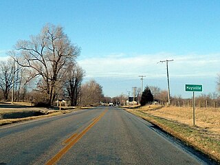
Maysville is an unincorporated community and census-designated place (CDP) in Benton County, Arkansas, United States. It is the westernmost settlement in the state of Arkansas. Per the 2020 census, the population was 117. It is located in the Northwest Arkansas region.
Pedro is an unincorporated community in Benton County, Arkansas, United States.

War Eagle is an unincorporated community in Benton County, Arkansas, United States. It is the location of War Eagle Bridge, which carries CR 98 over War Eagle Creek and is listed on the National Register of Historic Places.
Corley is an unincorporated community in Logan County, Arkansas, United States. It is the location of Burnett Springs, which is located at the end of County Road 704, Cove Creek Bridge, on AR 309 over Cove Creek, Cove Creek Tributary Bridge, on AR 309 over a tributary of Cove Creek, Cove Lake Bathhouse, located on Forest Service Rd. 1608A in the Ozark-St. Francis National Forest and Cove Lake Spillway Dam-Bridge located on AR 309 in the Ozark-St. Francis National Forest. All five of these places are listed on the National Register of Historic Places.

New Blaine is an unincorporated community and census-designated place (CDP) in Logan County, Arkansas, United States. Per the 2020 census, the population was 173.
Bates is an unincorporated community in Scott County, Arkansas, United States. It is the location or nearest community of Bates School, at 1074 Bates School Rd., which is listed on the U.S. National Register of Historic Places.

The Osage Mills Dam is a historic dam in rural Benton County, Arkansas. It impounds Little Osage Creek, just upstream of Mill Dam Road, between Rogers and the Northwest Arkansas Regional Airport. The dam was built c. 1890 out of coursed stone with a rusticated face. It was built to provide power to a grist mill that served the area, of which only a small portion of the millrace remains visible. The dam is the only known structure of its type in the county.

The Piercy Farmstead is a historic farm complex on Osage Mills Road in Osage Mills, Arkansas. It includes a c. 1909 vernacular Colonial Revival farmhouse, and is unusual for the collection of ten surviving agricultural outbuildings, including storage buildings, chicken houses, a barn, privy, grain crib, and well house. The house is a two-story wood-frame structure, with a rear extension giving it a T shape. A single-story porch with simple classical columns extends across the symmetrical front.
Jolly is an unincorporated community in eastern Newton County, in the U.S. state of Missouri. A variant name was "Jollification". The community is on Capps Creek approximately eight miles west-southwest of Monett in adjacent Barry County and five miles southwest of Pierce City in southwest Lawrence County.
Osage is an unincorporated community in Carroll County, in the U.S. state of Arkansas. The community is on the south side of Osage Creek at the junction of Osage and Kenner Creeks. U.S. Route 412 (US 412) passes on the north side of Osage Creek.
Osage Creek is a stream in Benton and Washington counties in northwest Arkansas. It is a tributary of the Illinois River.
References
- ↑ U.S. Geological Survey Geographic Names Information System: Osage Mills, Arkansas
- ↑ Centerton, Arkansas, 7.5 Minute Topographic Quadrangle, USGS, 1971 (1982 rev)
- ↑ "National Register Information System". National Register of Historic Places . National Park Service. March 13, 2009.
Municipalities and communities of Benton County, Arkansas, United States | ||
|---|---|---|
| Cities |  | |
| Towns | ||
| Townships | ||
| CDPs | ||
| Other communities | ||
| Ghost towns | ||
| Footnotes | ‡This populated place also has portions in an adjacent county or counties Bethel Heights, a former municipality, is now a part of Springdale | |
36°16′52″N94°16′08″W / 36.28111°N 94.26889°W
| | This article about a location in Benton County, Arkansas is a stub. You can help Wikipedia by expanding it. |