
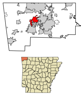
Benton County is a county in the Northwest region of the U.S. state of Arkansas. Created as Arkansas' 35th county on September 30, 1836, Benton County contains thirteen incorporated municipalities, including Bentonville, the county seat, and Rogers, the most populous city. The county was named after Thomas Hart Benton, a U.S. Senator from Missouri influential in Arkansas statehood.

Bella Vista is a city in Benton County, Arkansas, United States. First established in 1917 as a summer resort destination, Bella Vista has evolved and redesigned itself over the succeeding years. Bella Vista became a retirement community in 1965, and, after much contention and a 2006 vote of its property owners, became an incorporated city.
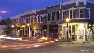
Bentonville is the ninth-most populous city in the US state of Arkansas, and the county seat of Benton County. The city is centrally located in the county with Rogers adjacent to the east. The city is the birthplace and headquarters of Walmart, the world's largest retailer. It is one of the four main cities in the three-county Northwest Arkansas Metropolitan Statistical Area, which is ranked 105th in terms of population in the United States with 546,725 residents in 2020, according to the United States Census Bureau. The city itself had a population of 54,164 at the 2020 Census, an increase of 53% from the 2010 Census. Bentonville is considered to be one of the fastest growing cities in the state and consistently ranks amongst the safest cities in Arkansas.
Centerton is a city in Benton County, Arkansas, United States. Located west of Bentonville on Highway 102, Centerton has grown from a railroad stop and fruit orchard community in the early 20th century into a suburban bedroom community within the rapidly growing Northwest Arkansas (NWA) region. The city's population has grown from 491 in 1990 to 16,244 in 2019. Centerton is considered to be one of the fastest growing cities in Arkansas and consistently ranks amongst the safest cities in the state.

Benton is a city in and the county seat of Saline County, Arkansas, United States and a suburb of Little Rock. It was established in 1837. At the 2020 census, the city had a population of 35,014, making it the 12th most populous city in Arkansas. It is part of the Little Rock–North Little Rock–Conway Metropolitan Statistical Area. The city of Benton, first settled in 1833 and named after Missouri Senator Thomas Hart Benton, was formally chartered in 1836 when Arkansas became a state.
Bentonville may refer to:

Highway 72 is a designation for two east–west state highways in Benton County, Arkansas. A western route of 26.32 miles (42.36 km) runs east from Highway 43 at Maysville to U.S. Route 71B (US 71B) in Bentonville. A second route of 12.67 miles (20.39 km) begins at Interstate 49/US Route 71 (I-49/US 71) in Bentonville and runs northeast to US 62 near Avoca. The route is one of the original Arkansas state highways.

Highway 88 is a designation for five state highways in Arkansas. All routes are maintained by the Arkansas Department of Transportation (ArDOT).
There are a number of schools referred to as Norwood School:
Northwest Arkansas Democrat-Gazette is a daily newspaper in Fayetteville, Arkansas owned by Northwest Arkansas Newspapers and has circulation of 17,807 copies.

Brightwater is a community in Benton County, Arkansas, United States. It is the location of Springfield to the Fayetteville Road-Brightwater Segment, which is located at N Old Wire Road/Benton Cty Rd. 67, south of US 62 and is listed on the National Register of Historic Places.

Cherokee City is an unincorporated census-designated place (CDP) in Benton County, Arkansas, United States. Per the 2020 census, the population was 73. It is the location of Coon Creek Bridge, which is located on Cty Rd. 24 and is listed on the National Register of Historic Places. The community was named for the Cherokee, since the Trail of Tears crossed the landscape when the Cherokee migrated west to Indian territory, now Oklahoma in the late 1830s. The town is within the Northwest Arkansas region, located about 5 miles east of Oklahoma and 4 miles south of the Missouri state line.
Larue is an unincorporated community in Benton County, Arkansas, United States. Larue was established in the late 19th century as a community for orchard workers. In the 1920s, the community transitioned to an economy based on animal husbandry and grain farming as orchard production declined in the area.
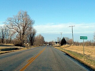
Maysville is an unincorporated community and census-designated place (CDP) in Benton County, Arkansas, United States. It is the westernmost settlement in the state of Arkansas. Per the 2020 census, the population was 117. It is located in the Northwest Arkansas region.

War Eagle is an unincorporated community in Benton County, Arkansas, United States. It is the location of War Eagle Bridge, which carries CR 98 over War Eagle Creek and is listed on the National Register of Historic Places.
Arnett is an unincorporated community in White River Township, Washington County, Arkansas, United States. It is located on Arkansas Highway 74.

Illinois Township is one of thirty-seven townships in Washington County, Arkansas, USA. As of the 2000 census, its total population was 655.

The Norwood School is a historic school building on Old Norwood Church Road near the unincorporated community of Norwood in south Benton County, Arkansas. It is a modest single-story stone building, fashioned out of rough-cut local fieldstone, topped by a hip roof with exposed rafter ends. A pair of entrances are sheltered by a gabled portico supported by a stone arch. It was built by the Works Progress Administration in 1937, and is the only building of its type in Benton County. The property also includes an original stone outhouse.

Northwest Arkansas (NWA) is a metropolitan area and region in Arkansas within the Ozark Mountains. It includes four of the ten largest cities in the state: Fayetteville, Springdale, Rogers, and Bentonville, the surrounding towns of Benton and Washington counties, and adjacent rural Madison County, Arkansas. The United States Census Bureau-defined Fayetteville–Springdale–Rogers Metropolitan Statistical Area includes 3,213.01 square miles (8,321.7 km2) and 590,337 residents, ranking NWA as the 98th most-populous metropolitan statistical area in the U.S. and the 13th fastest growing in the United States.


