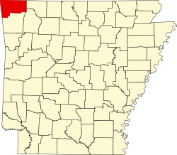
War Eagle, Arkansas Wareagle, War Eagle Mills | |
---|---|
Coordinates: 36°16′04″N93°56′28″W / 36.26778°N 93.94111°W | |
Country | United States |
State | Arkansas |
County | Benton |
Elevation | 359 m (1,178 ft) |
GNIS feature ID | 78688 [1] |
War Eagle is an unincorporated community in Benton County, Arkansas, United States. [1] It is the location of (or is the nearest community to) War Eagle Bridge, which carries CR 98 over War Eagle Creek and is listed on the National Register of Historic Places. [2]
Variant names were "Blackburn Mill", "Wareagle", and "War Eagle Mills". [1] The community takes its name from War Eagle Mill, a local gristmill on War Eagle Creek. [3] A post office called War Eagle Mills was established in 1876, the name was changed to Wareagle in 1894, and the post office closed in 1967. [4]
Walnut Shade is an unincorporated community in Taney County, Missouri, United States. It is located approximately six miles northwest of Forsyth on U.S. Route 160. The town sits at the confluence of Bull and Bear Creeks. Walnut Shade is part of the Branson, Missouri Micropolitan Statistical Area. The ZIP Code for Walnut Shade is 65771.
Capps Creek is a 13.4-mile-long (21.6 km) stream in Newton County, Missouri, United States. It is a tributary of Shoal Creek, and its water flows from there into the Spring River, then the Neosho River, the Arkansas River, and ultimately the Mississippi River. Capps Creek is best known for Jolly Mill Park, located at the old township site of Jollification, Missouri.
Ellendale is a ghost town in Polk County, Oregon, United States, about two and a half miles west of Dallas. It was the first settlement in present-day Polk County by non-Kalapuyans. The community's name changed over the years, with the first post office in Polk County being opened in this locality as "O'Neils Mills" in 1850. The post office was renamed "Nesmiths" in 1850 and discontinued in 1852. The community was eventually renamed Ellendale.
Brightwater is a community in Benton County, Arkansas, United States. It is the location of Springfield to the Fayetteville Road-Brightwater Segment, which is located at N Old Wire Road/Benton Cty Rd. 67, south of US 62 and is listed on the National Register of Historic Places.
Cherokee City is an unincorporated census-designated place (CDP) in Benton County, Arkansas, United States. Per the 2020 census, the population was 73. It is the location of Coon Creek Bridge, which is located on Cty Rd. 24 and is listed on the National Register of Historic Places. The community was named for the Cherokee, since the Trail of Tears crossed the landscape when the Cherokee migrated west to Indian territory, now Oklahoma in the late 1830s. The town is within the Northwest Arkansas region, located about 5 miles east of Oklahoma and 4 miles south of the Missouri state line.
Colville is an unincorporated community in Benton County, Arkansas, United States. It is the location of Mt. Hebron M.E. Church South and Cemetery, which is located at 1079 Mt. Hebron Road and is listed on the National Register of Historic Places.
Maysville is an unincorporated community and census-designated place (CDP) in Benton County, Arkansas, United States. It is the westernmost settlement in the state of Arkansas. Per the 2020 census, the population was 117. It is located in the Northwest Arkansas region.
Osage Mills is an unincorporated community in Benton County, Arkansas, United States. The millsite and associated dam is located on Little Osage Creek about eight miles southwest of Rogers. It is the location of the following places listed on the National Register of Historic Places on January 28, 1988:
Bear Creek Springs is an unincorporated community in Boone County, Arkansas, United States. It is the location of Bear Creek Motel, which is located on U.S. 65 and is listed on the National Register of Historic Places.
Pedro is an unincorporated community in Benton County, Arkansas, United States.
Durham is an unincorporated community in eastern Washington County, Arkansas, United States. The community is on Arkansas Highway 16 along the White River valley between Elkins to the northwest and Thompson in Madison County to the southeast. Its elevation is 1,247 feet (380 m).
Natural Dam is an unincorporated community in Crawford County, Arkansas, United States. Natural Dam is located on Arkansas Highway 59, 6 miles (9.7 km) north-northwest of Cedarville. Natural Dam has a post office with ZIP code 72948. The now-replaced Lee Creek Bridge, which was listed on the National Register of Historic Places, was located in the community.
The War Eagle Bridge is a historic bridge in War Eagle, Arkansas, United States, that is listed on the National Register of Historic Places.
War Eagle Mill is a working gristmill in Benton County, Arkansas. A mill has been located on the site as early as 1832, but was destroyed three times, and last rebuilt in 1973. The mill currently operates as an undershot gristmill, and houses a store and restaurant. The mill is located approximately 10 miles east of the city of Rogers in War Eagle, Arkansas.
Jolly is an unincorporated community in eastern Newton County, in the U.S. state of Missouri. A variant name was "Jollification". The community is on Capps Creek approximately eight miles west-southwest of Monett in adjacent Barry County and five miles southwest of Pierce City in southwest Lawrence County.
Denver is a community in Carroll County in northwest Arkansas, United States. Denver is located on the east bank of Long Creek near the confluence of Dry Creek with Long Creek and approximately one mile west of the Carroll-Boone county line. The community is accessed by county road from Arkansas Highway 396, which passes about 1.5 miles to the north. Farewell is about three miles to the west.
Yocum is a community in Carroll County in northwest Arkansas, United States. The community is located on Arkansas Highway 103 and the west bank of Yocum Creek. The site is three miles southeast of Oak Grove and six miles north of Green Forest.
Wheeler is an unincorporated community in Washington County, in the U.S. state of Arkansas. The community is approximately four miles northwest of Fayetteville and lies adjacent to the Clear Creek floodplain.
Osage is an unincorporated community in Carroll County, in the U.S. state of Arkansas. The community is on the south side of Osage Creek at the junction of Osage and Kenner Creeks. U.S. Route 412 (US 412) passes on the north side of Osage Creek.
Drakes Creek is an unincorporated community in Madison County, in the U.S. state of Arkansas.
Media related to War Eagle, Arkansas at Wikimedia Commons
36°16′04″N93°56′28″W / 36.26778°N 93.94111°W