
The Battle of Prairie Grove was a battle of the American Civil War fought on December 7, 1862. While tactically indecisive, the battle secured the Union control of northwestern Arkansas.
Magnet Cove is a census-designated place (CDP) and former town in Hot Spring County, Arkansas, United States. It is located in the Ouachita Mountains southeast of Hot Springs, on Arkansas Highway 51 north of U.S. Highway 270. As of the 2020 census, the town of Magnet Cove had a population of 692.
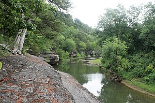
Lee Creek is an unincorporated community in Crawford County, Arkansas, lying along Highway 220 and Lee Creek north of Cedarville.

Nittany Valley is an eroded anticlinal valley located in Centre County, Pennsylvania. It is separated from the Bald Eagle Valley by Bald Eagle Mountain and from Penns Valley by Mount Nittany. The valley is closed to the north by a high plateau that joins these two mountain ridges, but is open to the south at the southern terminus of Mount Nittany. The valley drains to Bald Eagle Creek through water gaps in Bald Eagle Mountain formed by Spring Creek and Fishing Creek, along with smaller streams running through Curtain Gap and Howard Gap. The northwest side of the valley between the Bald Eagle Mountain ridge and the lower Sand Ridge is also known as the Little Nittany Valley.

Spence Field is a mountain highland meadow in the Great Smoky Mountains, located in the Southeastern United States. It has an elevation of 4,920 feet above sea level. The Appalachian Trail traverses the field, and a backcountry shelter just off the trail provides an overnight stopover for through-hikers.

The Quapaw Area Council is a regional council of the Boy Scouts of America. It is the largest council in Arkansas in both area and members and is headquartered in Little Rock. The council serves over 18,000 youth and 3,600 adults in thirty-nine counties divided into ten districts, and approximately 100 boys become Eagle Scouts each year.

War Eagle is an unincorporated community in Benton County, Arkansas, United States. It is the location of War Eagle Bridge, which carries CR 98 over War Eagle Creek and is listed on the National Register of Historic Places.
Corley is an unincorporated community in Logan County, Arkansas, United States. It is the location of Burnett Springs, which is located at the end of County Road 704, Cove Creek Bridge, on AR 309 over Cove Creek, Cove Creek Tributary Bridge, on AR 309 over a tributary of Cove Creek, Cove Lake Bathhouse, located on Forest Service Rd. 1608A in the Ozark-St. Francis National Forest and Cove Lake Spillway Dam-Bridge located on AR 309 in the Ozark-St. Francis National Forest. All five of these places are listed on the National Register of Historic Places.
Cove Creek Bridge may refer to:

The Cove Creek Bridge is a historic bridge, carrying Arkansas Highway 309 across Cove Creek, south of the hamlet of Corley, Arkansas in the Ozark-St. Francis National Forest. It is a two-span closed-spandrel masonry arch structure, with each span measuring 13 feet (4.0 m) and an overall structure length of 26 feet (7.9 m). It is built entirely out of stone, with a concrete and asphalt deck, and concrete barriers at the sides. It was built in 1936 with funding support from the Works Progress Administration.
Floss is an unincorporated community in Boston Township in southwestern Washington County, Arkansas, United States. The community is located on Cove Creek. Odell is to the southwest and Strickler lies to the northeast.

Brush Creek Township is one of 37 townships in Washington County, Arkansas, USA. As of the 2010 census, its unincorporated population was 2,877.

Township of Cove Creek is one of 37 townships in Washington County, Arkansas, USA. As of the 2000 census, its total population was 683. Part of Devil's Den State Park is located in Cove Creek Township.

Lee's Creek Township is one of thirty-seven townships in Washington County, Arkansas, USA. As of the 2000 census, its total population was 640.
The Cove Creek Bridge was a historic bridge in rural eastern Conway County, Arkansas. It carried Arkansas Highway 124 across Cove Creek, just west of the hamlet of Martinsville, and west of the city of Twin Groves. It was a three-span steel structure with a total length of 267 feet (81 m). The main span was a Pratt through truss 101 feet (31 m), mounted on concrete piers, while the approach spans on either end were smaller pony trusses each 83 feet (25 m) long. The bridge was built in 1957, and was the one of few Pratt truss bridges in the state.

The Cove Creek Tributary Bridge is a historic bridge in rural Logan County, Arkansas. It is a two-span closed-spandrel stone arch bridge, carrying Arkansas Highway 309 across a tributary of Cove Creek north of Corley in Ozark-St. Francis National Forest. Each of its arches is 11 feet (3.4 m) long, and the structure is an overall 23 feet (7.0 m) in length. Concrete barriers form the sides of the bridge on either side of the roadway. The bridge was built in 1936 under the auspices of the Arkansas Highway Commission.

The Cove Lake Spillway Dam and Bridge are historic structures in Ozark-St. Francis National Forest, north of Corley, Arkansas. The dam is built of earth and stone, and impounds Cove Lake, location of a recreation area in the national forest. The bridge is a five-span masonry arch structure, built across the dam spillway, where it carries Arkansas Highway 309. The dam and bridge were built in 1937 with funding from the Works Progress Administration, and is a fine example of the Rustic architecture WPA projects were known for.
War Eagle Creek is a stream in Benton, Washington and Madison counties of northwest Arkansas, United States, that is a tributary of the White River.

Withrow Springs State Park is a 786-acre (318 ha) public recreation area with campgrounds and hiking trails located five miles (8.0 km) north of Huntsville, Arkansas, that serves as a put-in for float trips on War Eagle Creek.


