
Arkansas is a landlocked state in the South Central region of the Southern United States. It borders Missouri to the north, Tennessee and Mississippi to the east, Louisiana to the south, Texas to the southwest, and Oklahoma to the west. Its name derives from the Osage language, and refers to their relatives, the Quapaw people. The state's diverse geography ranges from the mountainous regions of the Ozark and Ouachita Mountains, which make up the U.S. Interior Highlands, to the densely forested land in the south known as the Arkansas Timberlands, to the eastern lowlands along the Mississippi River and the Arkansas Delta.
A county seat is an administrative center, seat of government, or capital city of a county or civil parish. The term is in use in five countries: Canada, China, Hungary, Romania, and the United States. An equivalent term, shire town, is used in the U.S. state of Vermont and in several other English-speaking jurisdictions.

White County is a county located in the U.S. state of Arkansas. As of the 2020 census, the population was 76,822. The county seat is Searcy. White County is Arkansas's 31st county, formed on October 23, 1835, from portions of Independence, Jackson, and Pulaski counties and named for Hugh Lawson White, a Whig candidate for President of the United States. It is an alcohol prohibition or dry county, though a few private establishments can serve alcohol.

Washington County is a regional economic, educational, and cultural hub in the Northwest Arkansas region. Created as Arkansas's 17th county on November 30, 1848, Washington County has 13 incorporated municipalities, including Fayetteville, the county seat, and Springdale. The county is also the site of small towns, bedroom communities, and unincorporated places. The county is named for George Washington, the first President of the United States.

Van Buren County is a county located in the U.S. state of Arkansas. As of the 2020 census, the population was 15,796. The county seat is Clinton. The county was formed on November 11, 1833, and named for Martin Van Buren, President of the United States, who was Vice President at the time of the county's formation. Van Buren County was a dry county until November 3, 2020, as the county residents voted to make it a wet county.
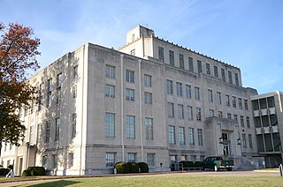
Sebastian County is a county located in the U.S. state of Arkansas. As of the 2020 census, the population was 127,799, making it the fourth-most populous county in Arkansas. The county has two county seats, Greenwood and Fort Smith.

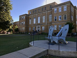
Searcy County is a county located in the U.S. state of Arkansas. As of the 2020 census, the population was 7,828. The county seat is Marshall. The county was formed December 13, 1838, from a portion of Marion County and named for Richard Searcy, the first clerk and judge in the Arkansas Territory. The city of Searcy, Arkansas, some 70 miles away, shares the name despite having never been part of Searcy County. The county is an alcohol prohibition or dry county.

Pulaski County is a county in the U.S. state of Arkansas. With a population of 399,125 as of the 2020 United States Census, it is the most populous county in Arkansas. The county is included in the Little Rock–North Little Rock–Conway metropolitan area. Its county seat is Little Rock, which is also Arkansas's capital and largest city.

Marion County is located in the Ozark Mountains in the U.S. state of Arkansas. The county is named for Francis Marion, the famous "Swamp Fox" of the Revolutionary War. Created as Arkansas's 35th county in 1836, Marion County is home to one incorporated town and four incorporated cities, including Yellville, the county seat. The county is also the site of numerous unincorporated communities and ghost towns. The county included part of what is now Searcy County, Arkansas, with many opposing to dividing them, which helped fueled the bloody Tutt-Everett War between 1844 and 1850.

Lee County is a county located in the U.S. state of Arkansas. With its eastern border formed by the Mississippi River, it is considered to be part of the Arkansas Delta. As of the 2020 census, the population was 8,600. The county seat is Marianna.
Izard County is a county located in the U.S. state of Arkansas. As of the 2020 census, the population was 13,577. The county seat is Melbourne. Izard County is Arkansas's 13th county, formed on October 27, 1825, and named for War of 1812 General and Arkansas Territorial Governor George Izard. It is an alcohol prohibition or dry county.
Independence County is a county located in the U.S. state of Arkansas. As of the 2020 census, the population was 37,938. The county seat is Batesville. Independence County is Arkansas's ninth county, formed on October 20, 1820, from a portion of Lawrence County and named in commemoration of the Declaration of Independence. It is an alcohol prohibition or dry county.

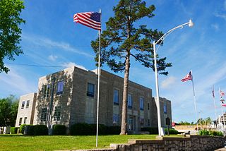
Grant County is a county in the U.S. state of Arkansas. Its population was 17,958 at the 2020 United States Census. The county seat is Sheridan.
Faulkner County is a county located in the Central Arkansas region of the U.S. state of Arkansas. As of the 2020 census, the population was 123,498, making it the fifth most populous of Arkansas's 75 counties. The county seat and largest city is Conway. Faulkner County was created on April 12, 1873, one of nine counties formed during Reconstruction, and is named for Sandford C. Faulkner, better known as Sandy Faulkner, a popular figure in the state at the time.

Crittenden County is a county located in the U.S. state of Arkansas. As of the 2020 census, the population was 48,163. The county seat is Marion, and the largest city is West Memphis.

Cleburne County is a county located in the U.S. state of Arkansas. As of the 2020 census, the population was 24,711. The county seat and most populous city is Heber Springs. The county was formed on February 20, 1883, as the last of Arkansas's 75 counties to be formed. It is named for Confederate Major-General Patrick Cleburne. Cleburne is an alcohol prohibition or dry county.

Carroll County is a county located in the U.S. state of Arkansas. As of the 2020 census, the population was 28,260. The county has two county seats, Berryville and Eureka Springs. Carroll County is Arkansas's 26th county, formed on November 1, 1833, and named after Charles Carroll, the last surviving signer of the United States Declaration of Independence.
Onda or Ondas may refer to:
The following is an alphabetical list of articles related to the U.S. State of Arkansas.


