
Washington County is a regional economic, educational, and cultural hub in the Northwest Arkansas region. Created as Arkansas's 17th county on November 30, 1848, Washington County has 13 incorporated municipalities, including Fayetteville, the county seat, and Springdale. The county is also the site of small towns, bedroom communities, and unincorporated places. The county is named for George Washington, the first President of the United States.
Baxter County is a county in the Ozark Mountains of Arkansas. Created as Arkansas's 66th county on March 24, 1873, the county has eight incorporated municipalities, including Mountain Home, its largest city and county seat. The county is named for Elisha Baxter, the tenth governor of Arkansas. It is coterminal with the Mountain Home Micropolitan Statistical Area.

Batesville is the county seat and largest city of Independence County, Arkansas, United States, 80 miles (183 km) northeast of Little Rock, the state capital. According to the 2010 Census, the population of the city was 10,268. The city serves as a regional manufacturing and distribution hub for the Ozark Mountain region and Northeast Arkansas.

Tontitown is a city in northern Washington County, Arkansas, United States. The community is located in the Ozark Mountains and was founded by Italian settlers in 1898. Known for its grapes and wines, Tontitown has hosted the Tontitown Grape Festival continuously since 1898. It is part of the Northwest Arkansas region, serving as a bedroom community for larger neighbors Fayetteville and Springdale. The town experienced a 160% growth in population between the 2000 and 2010 censuses.

Winslow is a city in southern Washington County, Arkansas, United States. The population was 365 as of the 2020 census. It is part of the Northwest Arkansas region.

The Ozarks, also known as the Ozark Mountains, Ozark Highlands or Ozark Plateau, is a physiographic region in the U.S. states of Missouri, Arkansas, Oklahoma and the extreme southeastern corner of Kansas. The Ozarks cover a significant portion of northern Arkansas and most of the southern half of Missouri, extending from Interstate 40 in central Arkansas to Interstate 70 in central Missouri.

The Boston Mountains is a Level III ecoregion designated by the Environmental Protection Agency (EPA) in the U.S. states of Arkansas and Oklahoma. Part of the Ozarks, the Boston Mountains are a deeply dissected plateau. The ecoregion is steeper than the adjacent Springfield Plateau to the north, and bordered on the south by the Arkansas Valley. The Oklahoma portion of the range is locally referred to as the Cookson Hills. There are several theories of how the mountains were named, though apparently none are related to the Massachusetts city.

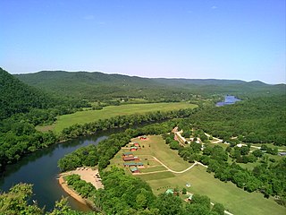
The Illinois River is a 145-mile-long (233 km) tributary of the Arkansas River in the U.S. states of Arkansas and Oklahoma. The Osage Indians named it Ne-eng-wah-kon-dah, which translates as "Medicine Stone River". The state of Oklahoma has designated its portion as a Scenic River.

Highway 16 is an east–west state highway in Arkansas. The route begins in Siloam Springs at US Highway 412 (US 412) and Highway 59 and runs east through Fayetteville and the Ozark National Forest to US Highway 67 Business (US 67B) in Searcy. Highway 16 was created during the 1926 Arkansas state highway numbering, and today serves as a narrow, winding, 2-lane road except for overlaps of 10 miles (16 km) through Fayetteville. Much of the highway winds through the Ozarks, including the Ozark National Forest, where a portion of the highway is designated as an Arkansas Scenic Byway. The route has two spur routes in Northwest Arkansas; in Fayetteville and Siloam Springs.
The Shiloh Museum of Ozark History, located in Springdale, Arkansas, is a regional history museum covering the Arkansas Ozarks. Programs, exhibits, and events relating to Ozark and Northwest Arkansas history are offered by the museum to the public. The museum has a large research library and the largest collection of historic images in Arkansas. The library is open to the public during regular museum hours. The geographic region covered by the museum includes the following six counties: Benton County, Boone County, Carroll County, Madison County, Newton County, and Washington County.

Alley Spring is an unincorporated community in Shannon County, Missouri, United States. It is located six miles west of Eminence on Route 106. The scenic Alley Mill, or "Old Red Mill" is located there on a spring and is located in the Ozark National Scenic Riverways. The Mill is operated as an Ozarks history museum. Nearby a one room schoolhouse and general store add to the feeling of the restored historic hamlet. It once had a post office, but it is now closed and mail now comes from Eminence. The community is named after John Alley, a miller. It was originally named Mammoth Spring and later Barksdale Spring. These names were deemed too long by the Post Office Department of the time, so the village was renamed after a prominent local citizen, John Alley.
Summers is an unincorporated community and census-designated place (CDP) in far western Washington County, Arkansas, United States. It was first listed as a CDP in the 2020 census with a population of 166.

Canehill, also known as Cane Hill and Boonsboro, is an unincorporated community and census-designated place (CDP) in Washington County, Arkansas, United States. It was first listed as a CDP in the 2020 census with a population of 74.

The geography of Arkansas varies widely. The state is covered by mountains, river valleys, forests, lakes, and bayous in addition to the cities of Arkansas. Hot Springs National Park features bubbling springs of hot water, formerly sought across the country for their healing properties. Crowley's Ridge is a geological anomaly rising above the surrounding lowlands of the Mississippi embayment.

Wendling is an unincorporated community in Lane County, Oregon, United States, located northeast of Marcola. Wendling's post office operated from 1899 to 1952. The town was named for George X. Wendling, a San Francisco investor, who was the largest investor in Booth-Kelly's expansion into the Mohawk. Wendling was created as a company town for the Booth-Kelly Lumber Company.

Combs is an unincorporated community in southern Madison County, Arkansas, United States. It is located on Arkansas Highway 16 at the southern terminus of AR 295. The community is within the Ozark-St. Francis National Forest and just south of the upper White River. The community of Brashears is about two miles east on route 16. The population was 431 as of the 2021 census, the overwhelming majority of which was white.
Big Piney Creek is a river located in Ozark National Forest in the state of Arkansas. It is a tributary of the Arkansas River and therefore part of the Mississippi River watershed. Managed by the United States Forest Service, it flows for 70.8 miles (113.9 km) through Pope, Johnson and Newton counties. The headwaters of the creek are in a rugged, remote area just east of Arkansas Route 21 south of the community of Fallsville and the mouth of the creek empties into Lake Dardanelle on the Arkansas River.

The Fayetteville Shale is a geologic formation of Mississippian age composed of tight shale within the Arkoma Basin of Arkansas and Oklahoma. It is named for the city of Fayetteville, Arkansas, and requires hydraulic fracturing to release the natural gas contained within.
Wedington Woods is an unincorporated community in Litteral Township, Washington County, Arkansas, United States. It is located west of Fayetteville, north of Wedington Drive. A small grass airport exists named Wedington Woods Airport.

Northwest Arkansas (NWA) is a metropolitan area and region in Arkansas within the Ozark Mountains. It includes four of the ten largest cities in the state: Fayetteville, Springdale, Rogers, and Bentonville, the surrounding towns of Benton and Washington counties, and adjacent rural Madison County, Arkansas. The United States Census Bureau-defined Fayetteville–Springdale–Rogers Metropolitan Statistical Area includes 3,213.01 square miles (8,321.7 km2) and 590,337 residents, ranking NWA as the 98th most-populous metropolitan statistical area in the U.S. and the 13th fastest growing in the United States.


