
Washington County is a regional economic, educational, and cultural hub in the Northwest Arkansas region. Created as Arkansas's 17th county on November 30, 1848, Washington County has 13 incorporated municipalities, including Fayetteville, the county seat, and Springdale. The county is also the site of small towns, bedroom communities, and unincorporated places. The county is named for George Washington, the first President of the United States.

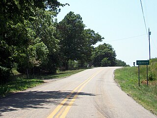
Elkins is a city in Washington County, Arkansas, United States. The community is located in the Boston Mountains, deep in the Ozark Mountains. A combination of the former unincorporated communities of Harris and Hood, Elkins was established in 1964. Located immediately east of Fayetteville in the Northwest Arkansas metropolitan statistical area, Elkins has been experiencing rapid growth in recent years, doubling in population between the 2000 and 2010 censuses.

Brightwater is a community in Benton County, Arkansas, United States. It is the location of Springfield to the Fayetteville Road-Brightwater Segment, which is located at N Old Wire Road/Benton Cty Rd. 67, south of US 62 and is listed on the National Register of Historic Places.

War Eagle is an unincorporated community in Benton County, Arkansas, United States. It is the location of War Eagle Bridge, which carries CR 98 over War Eagle Creek and is listed on the National Register of Historic Places.
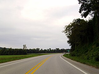
Durham is an unincorporated community in eastern Washington County, Arkansas, United States. The community is on Arkansas Highway 16 along the White River valley between Elkins to the northwest and Thompson in Madison County to the southeast. Its elevation is 1,247 feet (380 m).
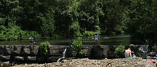
Savoy is an unincorporated community in Litteral Township, Washington County, Arkansas, United States. It is located on County Route 845 east of Lake Wedington. The Ozark National Forest is just west of the community. The Savoy area is marked with bluffs and streams. A distinctive feature is the dam on Clear Creek where a flour mill was once in operation. Savoy had a post office and businesses that no longer exist.
Black Oak is a community in White River Township, Washington County, Arkansas, United States. It is located between Greenland and Elkins and lies six miles southeast of Fayetteville.
Natural Dam is an unincorporated community in Crawford County, Arkansas, United States. Natural Dam is located on Arkansas Highway 59, 6 miles (9.7 km) north-northwest of Cedarville. Natural Dam has a post office with ZIP code 72948. The now-replaced Lee Creek Bridge, which was listed on the National Register of Historic Places, was located in the community.

Uniontown is an unincorporated community and census-designated place (CDP) in Crawford County, Arkansas, United States. It is located on Arkansas Highway 220 near the Oklahoma border, 4.5 miles (7.2 km) west-northwest of Cedarville. Uniontown has a post office with ZIP code 72955.

The Township of Elkins is one of thirty-seven townships in Washington County, Arkansas, USA. As of the 2000 census, its total population was 1,251.
Hubbard is an unincorporated community in Valley Township, Washington County, Arkansas, United States. It is located near the intersection of Washington County Road 21 and Hubbard Road.
Blackburn is an unincorporated community in Lee's Creek Township, Washington County, Arkansas, United States. It is located on Arkansas Highway 74, northeast of Devil's Den State Park.
Pitkin Corner is an unincorporated community in West Fork Township, Washington County, Arkansas, United States. It is located on Washington County Road 35 west of the Woolsey Bridge.
Strain is an unincorporated community in Richland Township, Washington County, Arkansas, United States. It is located between Fayetteville and Elkins. The community consists of a small number of homes located around a road junction near the Middle Fork White River.
Mount Olive is an unincorporated community in Richland Township in eastern Washington County, Arkansas, United States. It is located on Mount Olive Road, east of Elkins and the Mount Olive Cemetery is about one quarter mile west of the Washington-Madison county line.
Arnett is an unincorporated community in White River Township, Washington County, Arkansas, United States. It is located on Arkansas Highway 74.
Baldwin is a former unincorporated community in Fayetteville Township, Washington County, Arkansas, United States. It has since been annexed by Fayetteville. It is located in east Fayetteville along Huntsville Road near Lake Sequoyah toward Elkins.
White Rock is an unincorporated community in Fayetteville Township, Washington County, Arkansas, United States. It is located about three miles west of Fayetteville on Arkansas Highway 16. Goose Creek is just south of the community.
Viney Grove is an unincorporated community in Marrs Hill Township, Washington County, Arkansas, United States. It is located north of Prairie Grove and Prairie Grove Battlefield State Park along County Road 37.
Hicks is an unincorporated community in White River Township, Washington County, Arkansas, United States. It is located along Highway 74 south of Elkins.


