
Arkansas is a landlocked state in the South Central region of the Southern United States. It borders Missouri to the north, Tennessee and Mississippi to the east, Louisiana to the south, Texas to the southwest, and Oklahoma to the west. Its name derives from the Osage language, and refers to their relatives, the Quapaw people. The state's diverse geography ranges from the mountainous regions of the Ozark and Ouachita Mountains, which make up the U.S. Interior Highlands, to the densely forested land in the south known as the Arkansas Timberlands, to the eastern lowlands along the Mississippi River and the Arkansas Delta.

Washington County is a regional economic, educational, and cultural hub in the Northwest Arkansas region. Created as Arkansas's 17th county on November 30, 1848, Washington County has 13 incorporated municipalities, including Fayetteville, the county seat, and Springdale. The county is also the site of small towns, bedroom communities, and unincorporated places. The county is named for George Washington, the first President of the United States.

Arkansas City is a town in Desha County, Arkansas, United States. The population was 376 at the 2010 census. The town is the county seat of Desha County. Arkansas City Commercial District, located at Desoto Avenue and Sprague Street, is listed on the National Register of Historic Places.

Clarksville is a city in Johnson County, Arkansas, United States. As of the 2010 census the population was 9,178, up from 7,719 in 2000. As of 2018, the estimated population was 9,743. The city is the county seat of Johnson County. It is nestled between the Arkansas River and the foothills of the Ozark Mountains, and Interstate 40 and US Highway 64 intersect within the city limits. Clarksville-Johnson County is widely known for its peaches, scenic byways and abundance of natural outdoor recreational activities.

Jacksonville is a city in Pulaski County, Arkansas, United States, and a suburb of Little Rock. As of the 2010 census, the population of the city was 28,364. It is part of the Little Rock–North Little Rock–Conway Metropolitan Statistical Area with 729,135 people as of 2014.

Johnson is a city in Washington County, Arkansas, United States. The community is located in the Ozark Mountains and is surrounded by valleys and natural springs. Early settlers took advantage of these natural features and formed an economy based on mining lime, the Johnson Mill and trout. Although a post office was opened in the community in 1887, Johnson did not incorporate until it required the development of a city government to provide utility services in 1961. Located between Fayetteville and Springdale in the heart of the rapidly growing Northwest Arkansas metropolitan statistical area, Johnson has been experiencing a population and building boom in recent years, as indicated by a 46% growth in population between the 2000 and 2010 censuses.

The Arkansas River is a major tributary of the Mississippi River. It generally flows to the east and southeast as it traverses the U.S. states of Colorado, Kansas, Oklahoma, and Arkansas. The river's source basin lies in Colorado, specifically the Arkansas River Valley. The headwaters derive from the snowpack in the Sawatch and Mosquito mountain ranges. It flows east into Kansas and finally through Oklahoma and Arkansas, where it meets the Mississippi River.

The New Madrid Seismic Zone (NMSZ), sometimes called the New Madrid Fault Line, is a major seismic zone and a prolific source of intraplate earthquakes in the Southern and Midwestern United States, stretching to the southwest from New Madrid, Missouri.

The Verdigris River is a tributary of the Arkansas River in southeastern Kansas and northeastern Oklahoma in the United States. It is about 310 miles (500 km) long. Via the Arkansas, it is part of the Mississippi River watershed.

The Mulberry River is a 70-mile-long (110 km) tributary of the Arkansas River in northwestern Arkansas in the United States. Via the Arkansas River, it is part of the watershed of the Mississippi River. It has been designated a National Wild and Scenic River. The drainage basin of the Mulberry River has an area of 373 square miles (970 km2) and the annual average mean flow of the river near its mouth is 557 cubic feet per second.
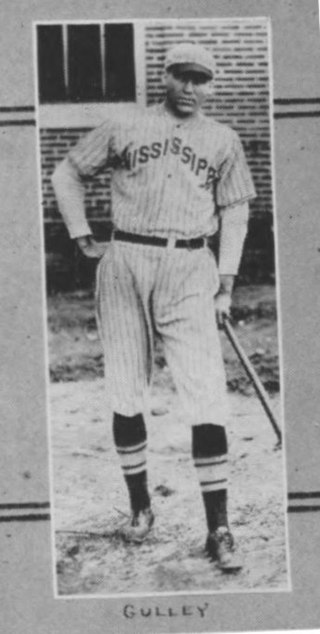
Thomas Jefferson Gulley was a professional baseball right fielder and pinch hitter. He was 5 ft 11 in (1.80 m) and weighed 178 pounds (81 kg). He went to Mississippi College. Gulley played first base for the Little Rock Travelers in the Southern Association for six seasons. He holds the Travelers' highest single-season batting average at .378 in 1925.
Savoy is an unincorporated community in Litteral Township, Washington County, Arkansas, United States. It is located on County Route 845 east of Lake Wedington. The Ozark National Forest is just west of the community. The Savoy area is marked with bluffs and streams. A distinctive feature is the dam on Clear Creek where a flour mill was once in operation. Savoy had a post office and businesses that no longer exist.
Big Piney Creek is a river located in Ozark National Forest in the state of Arkansas. It is a tributary of the Arkansas River and therefore part of the Mississippi River watershed. Managed by the United States Forest Service, it flows for 70.8 miles (113.9 km) through Pope, Johnson and Newton counties. The headwaters of the creek are in a rugged, remote area just east of Arkansas Route 21 south of the community of Fallsville and the mouth of the creek empties into Lake Dardanelle on the Arkansas River.
Baldwin is a former unincorporated community in Fayetteville Township, Washington County, Arkansas, United States. It has since been annexed by Fayetteville. It is located in east Fayetteville along Huntsville Road near Lake Sequoyah toward Elkins.
White Rock is an unincorporated community in Fayetteville Township, Washington County, Arkansas, United States. It is located about three miles west of Fayetteville on Arkansas Highway 16. Goose Creek is just south of the community.

Johnson Township is one of thirty-seven townships in Washington County, Arkansas, USA. As of the 2000 census, its total population was 3,076.

Lee's Creek Township is one of thirty-seven townships in Washington County, Arkansas, USA. As of the 2000 census, its total population was 640.
Wedington Woods is an unincorporated community in Litteral Township, Washington County, Arkansas, United States. It is located west of Fayetteville, north of Wedington Drive. A small grass airport exists named Wedington Woods Airport.
Habberton is an unincorporated community in Prairie Township, Washington County, Arkansas, United States. It is located along the city limits of Goshen at the intersection of Habberton Road and Habberton Avenue.
Wyman is an unincorporated community in Wyman Township, Washington County, Arkansas, United States. It is located east of the White River, north of Lake Sequoyah, southwest of Goshen, and east of Fayetteville.


