
Washington County is a regional economic, educational, and cultural hub in the Northwest Arkansas region. Created as Arkansas's 17th county on November 30, 1848, Washington County has 13 incorporated municipalities, including Fayetteville, the county seat, and Springdale. The county is also the site of small towns, bedroom communities, and unincorporated places. The county is named for George Washington, the first President of the United States.

DeWitt is the second largest city in Arkansas County, Arkansas, United States, which also serves as the county seat of the southern district of Arkansas County. Population was 3,292 at the time of the 2010 census. The city is located on the Arkansas Grand Prairie, known for rice farming and duck hunting. DeWitt is home to the DeWitt School District and the DeWitt Municipal Airport.

Farmington is a city in Washington County, Arkansas, United States. The community is nestled in a valley among the Boston Mountains, a subset of the Ozark Mountains. Although the first settlers came from the Deep South in 1828, the community did not incorporate until 1946. Located immediately west of Fayetteville in the Northwest Arkansas metropolitan statistical area, Farmington has been experiencing a population boom in recent years, as indicated by a 66% growth in population between the 2000 and 2010 censuses. It has been characterized as a bedroom community by the University of Arkansas Community Design Center.

Prairie Grove is a city in Washington County, Arkansas, United States. The population was 7,045 at the 2020 Census. It is part of the Northwest Arkansas region, and home to Prairie Grove Battlefield State Park.

Center Township is one of 37 townships in Washington County, Arkansas, USA. At the 2010 census, its total population was 1,518.
Starks is an unincorporated community in Center Township, Washington County, Arkansas, United States. It is located on U.S. Route 62 between Farmington and Prairie Grove.
Harris is an unincorporated community in Elkins Township, Washington County, Arkansas, United States. It is located east of Fayetteville and within the city limits of Elkins near Arkansas Highway 16.
Hogeye is an unincorporated community in Valley Township, Washington County, Arkansas, United States. It is located on Arkansas Highway 265 and Arkansas Highway 156.
Oak Grove is an unincorporated community in Springdale Township of northern Washington County, Arkansas, United States. It is located on the northwest side of Springdale just east of the combined U.S. routes 62, 71, 540.

Marrs Hill Township is one of thirty-seven townships in Washington County, Arkansas, USA. As of the 2000 census, its total population was 898.

Prairie Township is one of 37 townships in Washington County, Arkansas, USA. As of the 2000 census, its total population was 3,526.
Habberton is an unincorporated community in Prairie Township, Washington County, Arkansas, United States. It is located along the city limits of Goshen at the intersection of Habberton Road and Habberton Avenue.
Hazel Valley is an unincorporated community in Reed Township, Washington County, Arkansas, United States. It is located along County Route 47 northeast of Winslow.
Onda is an unincorporated community in Valley Township, Washington County, Arkansas, United States. It is located on County Route 29 south of Prairie Grove.
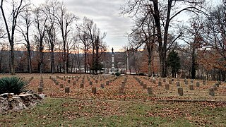
Fayetteville Confederate Cemetery is a cemetery for soldiers of the Confederate States located on the eastern side of Fayetteville in Washington County, Arkansas. Added to the National Register of Historic Places (NRHP) in 1993, the cemetery encompasses 3.5 acres (1.4 ha).
Sunset is an unincorporated community in Reed Township, Washington County, Arkansas, United States. It is located at the intersection of Sunset Road and CR 110.

The Hale Formation is a geologic formation in northern Arkansas that dates to the Morrowan Series of the early Pennsylvanian. The Hale Formation has two named members: the Cane Hill and the Prairie Grove Members. The lower member is the Cane Hill, a primarily sandstone and shale interval that unconformably overlies the Mississippian-age Pitkin Formation. The upper member, the Prairie Grove Member, is predominately limestone and conformably underlies the Bloyd Formation.
Tolu is an unincorporated community in Vineyard Township in western Washington County, Arkansas, United States. It is located at the intersection of Highway 59 and Bellamy Road about one half mile from the Arkansas - Oklahoma border. The community of Evansville lies approximately 1.3 miles to the south, across Evansville Creek.
Badger Grove is an unincorporated community in Prairie Township, White County, in the U.S. state of Indiana.
Prairie Township is one of 21 inactive townships in Madison County, Arkansas, USA. As of the 2010 census, its population was 1,632.


