
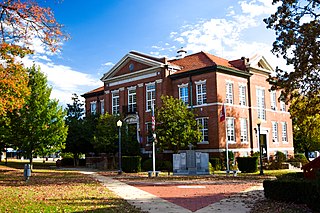
Yell County is a county in the U.S. state of Arkansas. As of the 2020 census, the population was 20,263. The county has two county seats, Dardanelle and Danville. Yell County is Arkansas's 42nd county, formed on December 5, 1840, from portions of Scott and Pope counties. It was named after Archibald Yell, who was the state's first member of the United States House of Representatives and the second governor of Arkansas. He died in combat at the Battle of Buena Vista during the Mexican–American War.

Washington County is a regional economic, educational, and cultural hub in the Northwest Arkansas region. Created as Arkansas's 17th county on November 30, 1848, Washington County has 13 incorporated municipalities, including Fayetteville, the county seat, and Springdale. The county is also the site of small towns, bedroom communities, and unincorporated places. The county is named for George Washington, the first President of the United States.
Boone County is a county located in the U.S. state of Arkansas, along the Missouri border. As of the 2020 census, the population was 37,373. The county seat is Harrison. It is Arkansas's 62nd county, formed on April 9, 1869.
Spring Lake may refer to:

Eureka Springs is a city in Carroll County, Arkansas, United States, and one of two county seats for the county. It is located in the Ozark Mountains of northwest Arkansas, near the border with Missouri. As of the 2020 census, the city population was 2,166.

U.S. Route 270 (US 270) is a spur of US 70. It travels for 643 miles (1,035 km) from Liberal, Kansas at US 54 and US 83 to White Hall, Arkansas at Interstate 530 (I-530) and US 65. It travels through the states of Arkansas, Oklahoma, and Kansas. It travels through the cities of Oklahoma City, Oklahoma, Hot Springs, Arkansas, and McAlester, Oklahoma.
Valley Township may refer to:

Highway 303 is a designation for three north–south state highways in Northwest Arkansas. Each connects sparsely populated rural areas to east-west corridors.

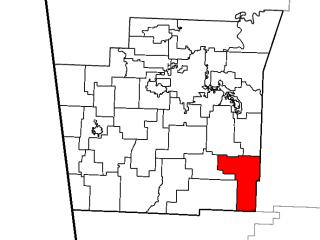
Brush Creek Township is one of 37 townships in Washington County, Arkansas, USA. As of the 2010 census, its unincorporated population was 2,877.
Spring Valley, Arkansas may refer to:
War Eagle Cove is an unincorporated community in Brush Creek Township, Washington County, Arkansas, United States. The Cove is located on the War Eagle Creek arm of Beaver Lake.

The Township of Elm Springs is one of thirty-seven townships in Washington County, Arkansas, US. As of the 2000 census, its total population was 1,912.
Reed Township is one of thirty-seven townships in Washington County, Arkansas, USA. As of the 2000 census, its total population was 410.
Hazel Valley is an unincorporated community in Reed Township, Washington County, Arkansas, United States. It is located along County Route 47 northeast of Winslow.

Northwest Arkansas (NWA) is a metropolitan area and region in Arkansas within the Ozark Mountains. It includes four of the ten largest cities in the state: Fayetteville, Springdale, Rogers, and Bentonville, the surrounding towns of Benton and Washington counties, and adjacent rural Madison County, Arkansas. The United States Census Bureau-defined Fayetteville–Springdale–Rogers Metropolitan Statistical Area includes 3,213.01 square miles (8,321.7 km2) and 590,337 residents, ranking NWA as the 98th most-populous metropolitan statistical area in the U.S. and the 13th fastest growing in the United States.

The Spring Valley School District 120 Building is a historic school building on County Road 379 in the small village of Spring Valley, Washington County, Arkansas, behind the Spring Valley Baptist Church. It is a single-story stone masonry structure with a hip roof and an entrance recessed under an arched corner porch. It was built in 1934, at the height of the Great Depression, apparently through local efforts, and is reflective of that period of public education in the Ozark region.


