
Arkansas is a landlocked state in the South Central region of the Southern United States. It borders Missouri to the north, Tennessee and Mississippi to the east, Louisiana to the south, Texas to the southwest, and Oklahoma to the west. Its name derives from the Osage language, and refers to their relatives, the Quapaw people. The state's diverse geography ranges from the mountainous regions of the Ozark and Ouachita Mountains, which make up the U.S. Interior Highlands, to the densely forested land in the south known as the Arkansas Timberlands, to the eastern lowlands along the Mississippi River and the Arkansas Delta.

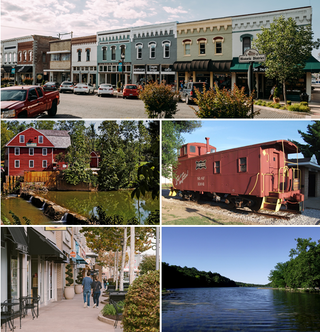
Washington County is a regional economic, educational, and cultural hub in the Northwest Arkansas region. Created as Arkansas's 17th county on November 30, 1848, Washington County has 13 incorporated municipalities, including Fayetteville, the county seat, and Springdale. The county is also the site of small towns, bedroom communities, and unincorporated places. The county is named for George Washington, the first President of the United States.

Dewey–Humboldt is a town in Yavapai County, Arizona, United States. The population of the town was 3,894 according to the 2010 census. The Dewey–Humboldt area was a census-designated place (CDP) at the 2000 census, at which time its population was 6,295.
Rogers is a city in Benton County, Arkansas, United States. Located in the Ozarks, it is part of the Northwest Arkansas region, one of the fastest growing metro areas in the country. Rogers was the location of the first Walmart store, whose corporate headquarters is located in neighboring Bentonville. Daisy Outdoor Products, known for its air rifles, has both its headquarters and its Airgun Museum in Rogers. The city houses a popular shopping center, the Pinnacle Hills Promenade, and a music venue, the Walmart AMP, that has housed performances by big-name artists and local performers alike.

The city of Harrison is the county seat of Boone County, Arkansas, United States. It is named after Marcus LaRue Harrison, a surveyor who laid out the city along Crooked Creek at Stifler Springs. According to 2019 Census Bureau estimates, the population of the city was 13,069, up from 12,943 at the 2010 census and it is the 30th largest city in Arkansas based on official 2019 estimates from the U.S. Census Bureau. Harrison is the principal city of the Harrison Micropolitan Statistical Area, which includes all of Boone and Newton counties.

Fayetteville is the second-most populous city in the U.S. state of Arkansas, the county seat of Washington County, and the most populous city in Northwest Arkansas. The city had a population of 93,949 as of the 2020 census, which was estimated to have increased to 101,680 by 2023. The city is on the outskirts of the Boston Mountains, deep within the Ozarks. It was named after Fayetteville, Tennessee, from which many settlers had come, and was incorporated on November 3, 1836. Fayetteville is included in the three-county Fayetteville–Springdale–Rogers metropolitan statistical area, with 576,403 residents in 2020.

Lynn Carol Woolsey is an American politician who served in the United States House of Representatives from California from 1993 to 2013. She was a member of the Democratic Party and represented California's 6th congressional district.

The first USS Woolsey (DD-77) was a Wickes-class destroyer in the United States Navy during World War I. She was named for Melancthon Taylor Woolsey.
Webster Lee "Webb" Hubbell is a former United States Associate Attorney General from 1993 to 1994 who as part of the Whitewater controversy pled guilty to one count of wire fraud and one count of failing to disclose a conflict of interest, and was sentenced to 21 months in prison.

Robert Rolla Woolsey was an American stage and screen comedian and half of the 1930s comedy team Wheeler & Woolsey.
United States v. One Book Called Ulysses, 5 F. Supp. 182, is a landmark decision by the United States District Court for the Southern District of New York in a case dealing with freedom of expression. At issue was whether James Joyce's 1922 novel Ulysses was obscene. In deciding it was not, Judge John M. Woolsey opened the door to importation and publication of serious works of literature that used coarse language or involved sexual subjects.

William Tripp Woolsey was an American competition swimmer for McKinley High School and Indiana University, who captured an Olympic gold medal in Helsinki in 1952, and a silver medal in Melbourne in 1956.

Woolsey Bridge was a truss bridge built in 1925, formerly located near West Fork, Arkansas. It carried County Route 35 over the West Fork of the White River for 303 feet (92 m). It is listed on the National Register of Historic Places.

Township of Crawford is one of 37 townships in Washington County, Arkansas, United States. As of the 2000 census, its total population was 800.

Robert James Woolsey Jr. is an American political appointee who has served in various senior positions. He headed the Central Intelligence Agency as Director of Central Intelligence from February 5, 1993, until January 10, 1995. He held a variety of government positions in the 1970s and 1980s, including as United States Under Secretary of the Navy from 1977 to 1979, and was involved in treaty negotiations with the Soviet Union for five years in the 1980s. His career also included time as a professional lawyer, venture capitalist and investor in the private sector.
Pitkin Corner is an unincorporated community in West Fork Township, Washington County, Arkansas, United States. It is located on Washington County Road 35 west of the Woolsey Bridge.

The Bloyd Formation, or Bloyd Shale, is a geologic formation in Arkansas. It preserves fossils dating back to the Carboniferous period.
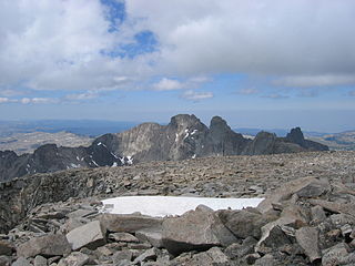
Mount Woolsey is located in the Bighorn Mountains in the U.S. state of Wyoming. The peak is the third highest in the range after Cloud Peak, which is only 1.3 miles (2.1 km) to the south, and the summit is located in the Cloud Peak Wilderness of Bighorn National Forest. Black Tooth Mountain, the second highest mountain in the Bighorns, is an adjacent summit only .20 mi (0.32 km) to the northwest. Mount Woolsey is on a knife-like ridge known as an arête and is connected to both Black Tooth Mountain and Cloud Peak by this ridge. Along the arête is another mountain peak known as The Innominate. A small glacier lies below the arête to the southeast of Mount Woolsey.

The Woolsey Fire was a wildfire that started in Los Angeles County and spread north to neighboring Ventura County, both located in the U.S. state of California. The fire ignited on November 8, 2018 and wasn't fully contained until November 21, 2018. The fire burned 96,949 acres of land, destroyed 1,643 structures, killed three people, and prompted the evacuation of more than 295,000 people. It was one of several fires in California that ignited on the same day, along with the nearby Hill Fire and the destructive Camp Fire in Northern California.
Sandy Woolsey is an American former artistic gymnast. She went to high school at Marcos de Niza in Tempe Arizona.


