Canehill, Arkansas

Last updated

Canehill, Arkansas
Canehill, Arkansas 72717.JPG
Main façade of the Canehill Post Office
USA Arkansas location map.svg
Red pog.svg
Canehill, Arkansas
Canehill's position in Arkansas.
Coordinates: 35°54′50″N94°23′51″W / 35.91389°N 94.39750°W / 35.91389; -94.39750
Country Flag of the United States.svg  United States
State Flag of Arkansas.svg  Arkansas
County Washington
Township Cane Hill
Established1839
Elevation
[1]
423 m (1,388 ft)
Population
 (2020)
  Total74
Time zone UTC-6 (Central (CST))
  Summer (DST) UTC-5 (CDT)
Zip code
72717
Area code 479
GNIS feature ID2805630 [1]

Canehill (also known as Cane Hill and Boonsboro) is an unincorporated community and census-designated place (CDP) in Washington County, Arkansas, United States. It was first listed as a CDP in the 2020 census with a population of 74. [2]

Contents

The community is located in the Ozark Mountains on the outskirts of the Northwest Arkansas metropolitan area. One of the most historic communities in the state, Canehill contains seventeen listings on the National Register of Historic Places (NRHP). The Cane Hill College began operations in 1834, which led to the rapid growth and development of the community as a center of higher education. The college and community suffered during the American Civil War, and was bypassed by the railroad, which chose a route through Lincoln. Recently, restoration and preservation of many historic buildings has been undertaken by a nonprofit organization, Historic Cane Hill Inc.

Geography

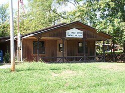
The post office at Canehill is 1322 feet above sea level. [3] Canehill is on Arkansas Highway 45, approximately 25 miles (40 km) southwest of Fayetteville and 6 miles (9.7 km) east of the Oklahoma border.

Considered a postal designation (ZIP code 72717), the population of the ZCTA was 847 [4] at the 2000 census.

History

Cane Hill College

In 1834, the Cumberland Presbyterians established the first collegiate learning institute in Arkansas, naming it the Cane Hill School, after a nearby geological feature. [5] The current Post Office was opened in 1839 and was originally unnamed. In 1843, it was named Boonsboro, and the town maintained this name throughout the American Civil War.

American Civil War

Cane Hill Battlefield, today listed on the NRHP Cane Hill Battlefield.JPG
Cane Hill Battlefield, today listed on the NRHP

The year of 1862 brought the Battle of Cane Hill.

Postwar years and decline

Only one Cane Hill College building remains today. Campus of Cane Hill College 003.jpg
Only one Cane Hill College building remains today.

In 1897, the Cumberland Presbyterian Church considered Cane Hill College [6] as the starting point for their "state" college. However, due to the nearby competition from Arkansas Industrial University, the decline of Cane Hill as a population center and its remote location, the Synod decided to open Arkansas Cumberland College [7] in Clarksville, Arkansas, a more centralized location. In 1891, Cane Hill College closed its doors permanently. In 1901, the community's name was changed to the current usage, that of Canehill. [3]

Economy

Early settlers were attracted to the area by natural springs, which were used in agricultural operations. The community served as a trading post and regional center for apple orchards to sell crops to merchants from Fort Smith. The locals also produced and sold sorghum, a tradition continuing today at the annual harvest festival.

Education

The community is served by the Lincoln Consolidated School District. [8] Lincoln High School is its sole high school.

Demographics

Historical population
CensusPop.Note
2020 74
U.S. Decennial Census [9]
2020 [10]

2020 census

Canehill CDP, Arkansas – Demographic Profile
(NH = Non-Hispanic)
Note: the US Census treats Hispanic/Latino as an ethnic category. This table excludes Latinos from the racial categories and assigns them to a separate category. Hispanics/Latinos may be of any race.
Race / EthnicityPop 2020 [10] % 2020
White alone (NH)5067.57%
Black or African American alone (NH)00.00%
Native American or Alaska Native alone (NH)11.35%
Asian alone (NH)00.00%
Pacific Islander alone (NH)11.35%
Some Other Race alone (NH)34.05%
Mixed Race/Multi-Racial (NH)1520.27%
Hispanic or Latino (any race)45.41%
Total74100.00%


Transportation

As of 2023, there is no fixed route transit service in Canehill. Ozark Regional Transit operates demand-response service in the area. [11] The nearest intercity bus service is provided by Jefferson Lines in Fayetteville. [12]

Related Research Articles

<span class="mw-page-title-main">Washington County, Arkansas</span> County in Arkansas, United States

Washington County is a regional economic, educational, and cultural hub in the Northwest Arkansas region. Created as Arkansas's 17th county on November 30, 1848, Washington County has 13 incorporated municipalities, including Fayetteville, the county seat, and Springdale. The county is also the site of small towns, bedroom communities, and unincorporated places. The county is named for George Washington, the first President of the United States.

<span class="mw-page-title-main">Fayetteville, Arkansas</span> City in Arkansas, United States

Fayetteville is the 2nd most populous city in Arkansas, the county seat of Washington County, and the most populous city in Northwest Arkansas. The city is on the outskirts of the Boston Mountains, deep within the Ozarks. Known as Washington until 1829, the city was named after Fayetteville, Tennessee, from which many of the settlers had come. It was incorporated on November 3, 1836, and was rechartered in 1867. Fayetteville is included in the three-county Northwest Arkansas Metropolitan Statistical Area, which is ranked 100th in terms of population in the United States with 576,403 in 2022 according to the United States Census Bureau. The city had a population of 99,285 in 2022.

<span class="mw-page-title-main">Lincoln, Arkansas</span> City in Arkansas, United States

Lincoln is a city in Washington County, Arkansas, United States. The population was 2,294 at the 2020 census. It is part of the Northwest Arkansas metro area.

Lanham is an unincorporated community and census-designated place in Prince George's County, Maryland. As of the 2020 United States Census it had a population of 11,282. The New Carrollton station as well as an Amtrak station are across the Capital Beltway in New Carrollton, Maryland. Doctors Community Hospital is located in Lanham.

<span class="mw-page-title-main">University of the Ozarks</span> Private university in Clarksville, Arkansas

University of the Ozarks is a private university in Clarksville, Arkansas. Enrollment averages around 900 students, representing 25 countries. U of O is affiliated with the Presbyterian Church (U.S.A.).

<span class="mw-page-title-main">Harrogate, Tennessee</span> City in Claiborne County, Tennessee, United States

Harrogate is the largest city in Claiborne County, Tennessee, United States. It is adjacent to Cumberland Gap National Historical Park.

<span class="mw-page-title-main">Ozark Acres, Arkansas</span> Census-designated place in Arkansas, United States

Ozark Acres is an unincorporated community, census-designated place (CDP), Suburban Improvement District (SID), and a Deeded Community in Sharp County, Arkansas, United States. It was first listed as a CDP in the 2020 census with a population of 692.

Summers is an unincorporated community and census-designated place (CDP) in far western Washington County, Arkansas, United States. It was first listed as a CDP in the 2020 census with a population of 166.

<span class="mw-page-title-main">Oark, Arkansas</span> Census-designated place in Arkansas, United States

Oark is an unincorporated community and census-designated place (CDP) in Johnson County, Arkansas, United States. Oark is located on Arkansas Highway 215, 16 miles (26 km) northwest of Clarksville. It was first listed as a CDP in the 2020 census with a population of 43.

<span class="mw-page-title-main">Bee Branch, Arkansas</span> Small town in Arkansas

Bee Branch is an unincorporated community and census-designated place (CDP) in Van Buren County, Arkansas, United States. It was first listed as a CDP in the 2020 census with a population of 293.

Appleton is an unincorporated community and census-designated place (CDP) in Griffin Township, Pope County, Arkansas, United States. It was first listed as a CDP in the 2020 census with a population of 399.

<span class="mw-page-title-main">Cane Hill College</span> United States historic place

Cane Hill College, originally Cane Hill School, was the first institution of higher learning in Arkansas. It operated in Canehill, Arkansas from 1834 until 1891.

<span class="mw-page-title-main">Cane Hill Township, Washington County, Arkansas</span> Township in Arkansas, United States

Cane Hill Township is one of 37 townships in Washington County, Arkansas, USA. As of the 2010 census, its unincorporated population was 1,530.

<span class="mw-page-title-main">Clyde, Arkansas</span> Unincorporated community in Arkansas, United States

Clyde is an unincorporated community in Cane Hill Township, Washington County, Arkansas, United States. Clyde is on Arkansas Highway 45, approximately 26 miles southwest of Fayetteville and six miles east of the Oklahoma border.

Cincinnati is an unincorporated community and census-designated place (CDP) in northwestern Washington County, Arkansas, United States. It was first listed as a CDP in the 2020 census with a population of 306.

<span class="mw-page-title-main">Evansville, Arkansas</span> Census-designated place in Arkansas, United States

Evansville is an unincorporated community and census-designated place (CDP) in southwest Washington County, Arkansas, United States. It was first listed as a CDP in the 2020 census with a population of 102.

Morrow is an unincorporated community and census-designated place (CDP) in Washington County, Arkansas, United States. A post office has been in operation at Morrow since 1883; The community had the name of G. W. Morrow, an early postmaster. it was first listed as a CDP in the 2020 census with a population of 263;

<span class="mw-page-title-main">Earle House (Canehill, Arkansas)</span> Historic house in Arkansas, United States

Earle House is a house in Canehill, Arkansas on Highway 45 built in 1859 to house Dr. Fountain R. Earle, the president of Cane Hill College. The property was added to the National Register of Historic Places along with many other Canehill properties in November 1982. The house, set well back from the highway, is a single-story wood-frame structure, with a side gable roof and a projecting gable-roof section on the front (western) facade. This projection has box columns supporting a delicate frieze and box cornice, with a raking cornice joining it to form a pediment. Chimneys are located at the gable ends.

Batavia is an unincorporated community and census-designated place (CDP) in Boone County, Arkansas, United States. It was first listed as a CDP in the 2020 census with a population of 328.

<span class="mw-page-title-main">Northwest Arkansas</span> Metropolitan area in Arkansas, United States

Northwest Arkansas (NWA) is a metropolitan area and region in Arkansas within the Ozark Mountains. It includes four of the ten largest cities in the state: Fayetteville, Springdale, Rogers, and Bentonville, the surrounding towns of Benton and Washington counties, and adjacent rural Madison County, Arkansas. The United States Census Bureau-defined Fayetteville–Springdale–Rogers Metropolitan Statistical Area includes 3,213.01 square miles (8,321.7 km2) and 576,403 residents, ranking NWA as the 98th most-populous metropolitan statistical area in the U.S. and the 13th fastest growing in the United States.

References

  1. 1 2 U.S. Geological Survey Geographic Names Information System: Canehill, Arkansas
  2. "Canehill CDP, Arkansas". United States Census Bureau . Retrieved April 7, 2022.
  3. 1 2 U.S. Geological Survey Geographic Names Information System: Canehill, Arkansas Canehill post office
  4. U.S. Census Bureau U.S. Census website Fact Sheet for ZCTA 72717
  5. "About Ozarks - Cane Hill School". Archived from the original on July 12, 2010. Retrieved July 8, 2007.
  6. "About Ozarks - Cane Hill College". Archived from the original on July 12, 2010. Retrieved January 10, 2011.
  7. "About Ozarks - Arkansas Cumberland College". Archived from the original on September 21, 2010. Retrieved January 10, 2011.
  8. "About". Lincoln Consolidated School District. Archived from the original on January 23, 2022. Retrieved August 29, 2019.
  9. "Decennial Census of Population and Housing by Decades". US Census Bureau.
  10. 1 2 "P2 HISPANIC OR LATINO, AND NOT HISPANIC OR LATINO BY RACE – 2020: DEC Redistricting Data (PL 94-171) – Canehill CDP, Arkansas". United States Census Bureau .
  11. "Demand Response" . Retrieved September 28, 2023.
  12. "Arkansas Bus Stops" . Retrieved September 28, 2023.