Township 1, Benton County, Arkansas

Last updated
Township 1
Township
USA Arkansas location map.svg
Red pog.svg
Township 1
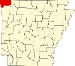
Location in Arkansas
Coordinates: 36°25′8″N93°58′23″W / 36.41889°N 93.97306°W / 36.41889; -93.97306 Coordinates: 36°25′8″N93°58′23″W / 36.41889°N 93.97306°W / 36.41889; -93.97306
Country Flag of the United States.svg  United States
State Flag of Arkansas.svg  Arkansas
County Benton
Area
  Total 130.96 sq mi (339.2 km2)
  Land 116.21 sq mi (301.0 km2)
  Water 14.75 sq mi (38.2 km2)  11.26%
Elevation 1,380 ft (420 m)
Population (2010)
  Total 13,223
  Density 113.8/sq mi (43.9/km2)
Time zone CST (UTC-6)
  Summer (DST) CDT (UTC-5)
Area code(s) 479
GNIS feature ID 1989186
U.S. Geological Survey Geographic Names Information System: Township 1, Benton County, Arkansas

Township 1 is one of thirteen townships in Benton County, Arkansas, USA. [1]

A civil township is a widely used unit of local government in the United States that is subordinate to a county. The term town is used in New England, New York, and Wisconsin to refer to the equivalent of the civil township in these states. Specific responsibilities and the degree of autonomy vary based on each state. Civil townships are distinct from survey townships, but in states that have both, the boundaries often coincide and may completely geographically subdivide a county. The U.S. Census Bureau classifies civil townships as minor civil divisions. Currently, there are 20 states with civil townships.

Benton County, Arkansas County in the United States

Benton County is a county located in the U.S. state of Arkansas. As of the 2010 census, the population was 221,339, making it the second-most populous county in Arkansas. The county seat is Bentonville. The county was formed on September 30, 1836 and was named after Thomas Hart Benton, a U.S. Senator from Missouri. In 2012, Benton County voters elected to make the county wet, or a non-alcohol prohibition location.

Arkansas State of the United States of America

Arkansas is a state in the southern region of the United States, home to over 3 million people as of 2018. Its name is of Siouan derivation from the language of the Osage denoting their related kin, the Quapaw Indians. The state's diverse geography ranges from the mountainous regions of the Ozark and the Ouachita Mountains, which make up the U.S. Interior Highlands, to the densely forested land in the south known as the Arkansas Timberlands, to the eastern lowlands along the Mississippi River and the Arkansas Delta.

Contents

Cities, towns, villages

Avoca, Arkansas Town in Arkansas, United States

Avoca is a town in Benton County, Arkansas, United States. The population was 488 at the 2010 census. It is part of the Fayetteville–Springdale–Rogers, AR-MO Metropolitan Statistical Area.

Garfield, Arkansas Town in Arkansas, United States

Garfield is a town in Benton County, Arkansas, United States. The population was 502 at the 2010 census. It is part of the Fayetteville–Springdale–Rogers, AR-MO Metropolitan Statistical Area.

Gateway, Arkansas Town in Arkansas, United States

Gateway is a town in Benton County, Arkansas, United States. The population was 405 at the 2010 census, up from 116 in 2000. It is part of the Fayetteville–Springdale–Rogers, AR-MO Metropolitan Statistical Area. The town's name reflects its situation as the "gateway" to and from Arkansas.

Cemeteries

The township contains Alpine Cemetery, Bayless Cemetery, Clantonville Cemetery, Dean Cemetery, Ford Cemetery, Liberty Cemetery, McReynolds Cemetery, Ozark Cemetery, Pratt Cemetery, Scott Cemetery, Snoderley Cemetery, Walnut Hill Cemetery, and Williams Cemetery. Two former cemeteries also exist: Henson Cemetery and Williams Cemetery.

Major routes

U.S. Route 62 in Arkansas highway in Arkansas

U.S. Route 62 is a U.S. highway running from El Paso, Texas northeast to Niagara Falls, New York. In the U.S. state of Arkansas, the route runs 329.9 miles from the Oklahoma border near Summers east to the Missouri border in St. Francis, serving the northern portion of the state. The route passes through several cities and towns, including Fayetteville, Springdale, Bentonville, Harrison, Mountain Home, Pocahontas, and also Piggott. US 62 runs concurrent with several highways in Arkansas including Interstate 49 and U.S. Route 71 between Fayetteville and Bentonville, U.S. Route 412 through much of the state, U.S. Route 65 in the Harrison area, and with U.S. Route 63 and U.S. Route 67 in northeast Arkansas.

Arkansas Highway 12 highway in Arkansas

Arkansas Highway 12 is an east–west state highway in Northwest Arkansas. The route runs 56.60 miles (91.09 km) from Oklahoma State Highway 116 near Cherokee City east to Arkansas Highway 23 near Clifty.

Arkansas Highway 37 highway in Arkansas

Arkansas Highway 37 is a designation for two state highways in Arkansas. The main segment of 52.40 miles (84.33 km) runs from McCrory to Cord. A short segment of 0.61 miles (0.98 km) runs north in Benton County from U.S. Route 62 to the Missouri state line.

Related Research Articles

Saline County, Arkansas County in the United States

Saline County is a county located in the U.S. state of Arkansas. As of the 2010 census, the population was 107,118. at the 2010 census. Its county seat and largest city is Benton. Saline County was formed on November 2, 1835, and named for the salt water (brine) springs in the area, however, it is pronounced "suh-LEAN" instead of the typical pronunciation, "SAY-lean". Until November 2014, it was an alcohol prohibition or dry county.

Crawford County, Arkansas County in the United States

Crawford County is a county located in the Ozarks region of the U.S. state of Arkansas. As of the 2010 census, the population was 61,948, making it the 12th-most populous of Arkansas's 75 counties. The county seat and largest city is Van Buren. Crawford County was formed on October 18, 1820 from the former Lovely County and Indian Territory, and was named for William H. Crawford, the United States Secretary of War in 1815.

Benton Township, Adair County, Missouri Township in Missouri, United States

Benton Township is one of ten townships in Adair County, Missouri, United States. As of the 2010 census, its population was 19,700. It is named for Thomas Hart Benton, US senator from Missouri.

Brush Creek Township, Washington County, Arkansas Township in Arkansas, United States

Brush Creek Township is one of thirty-seven townships in Washington County, Arkansas, USA. As of the 2010 census, its unincorporated population was 2,877.

Center Township, Washington County, Arkansas Township in Arkansas, United States

Center Township is one of thirty-seven townships in Washington County, Arkansas, USA. At the 2010 census, its total population was 1,518.

Cove Creek Township, Washington County, Arkansas Township in Arkansas, United States

Township of Cove Creek is one of thirty-seven townships in Washington County, Arkansas, USA. As of the 2000 census, its total population was 683. Part of Devil's Den State Park is located in Cove Creek Township.

Crawford Township, Washington County, Arkansas Township in Arkansas, United States

Township of Crawford is one of thirty-seven townships in Washington County, Arkansas, USA. As of the 2000 census, its total population was 800.

Durham Township, Washington County, Arkansas Township in Arkansas, United States

The Township of Durham is one of thirty-seven townships in Washington County, Arkansas, USA. As of the 2000 census, its total population was 839.

Dutch Mills Township, Washington County, Arkansas Township in Arkansas, United States

Dutch Mills is one of thirty-seven townships in Washington County, Arkansas, USA. As of the 2000 census, its total population was 321.

Elkins Township, Washington County, Arkansas Township in Arkansas, United States

The Township of Elkins is one of thirty-seven townships in Washington County, Arkansas, USA. As of the 2000 census, its total population was 1,251.

Elm Springs Township, Washington County, Arkansas Township in Arkansas, United States

The Township of Elm Springs is one of thirty-seven townships in Washington County, Arkansas, USA. As of the 2000 census, its total population was 1,912.

Litteral Township, Washington County, Arkansas Township in Arkansas, United States

Litteral Township is one of thirty-seven townships in Washington County, Arkansas, USA. As of the 2000 census, its total population was 1,410.

Goshen Township, Washington County, Arkansas Township in Arkansas, United States

Goshen Township is one of thirty-seven townships in Washington County, Arkansas, USA. As of the 2000 census, its total population was 1,656. The township contains the Town of Goshen and some surrounding unincorporated areas.

Illinois Township, Washington County, Arkansas Township in Arkansas, United States

Illinois Township is one of thirty-seven townships in Washington County, Arkansas, USA. As of the 2000 census, its total population was 655.

Greenland Township, Washington County, Arkansas Township in Arkansas, United States

Greenland Township is one of thirty-seven townships in Washington County, Arkansas, USA. As of the 2000 census, its total population was 2,114.

Lees Creek Township, Washington County, Arkansas Township in Arkansas, United States

Lee's Creek Township is one of thirty-seven townships in Washington County, Arkansas, USA. As of the 2000 census, its total population was 640.

Morrow Township, Washington County, Arkansas Township in Arkansas, United States

Morrow Township is one of thirty-seven townships in Washington County, Arkansas, USA. As of the 2000 census, its total population was 898.

Prairie Township, Washington County, Arkansas Township in Arkansas, United States

Prairie Township is one of 37 townships in Washington County, Arkansas, USA. As of the 2000 census, its total population was 3,526.

Reed Township, Washington County, Arkansas Township in Arkansas, United States

Reed Township is one of thirty-seven townships in Washington County, Arkansas, USA. As of the 2000 census, its total population was 410.

References

  1. "Township 1, Benton County, Arkansas". U.S. Census Bureau. Retrieved 17 August 2011.