Centerton is a city in Benton County, Arkansas, United States. Located west of Bentonville on Highway 102, Centerton has grown from a railroad stop and fruit orchard community in the early 20th century into a suburban bedroom community within the rapidly growing Northwest Arkansas (NWA) region. The city's population has grown from 491 in 1990 to 16,244 in 2019. Centerton is considered to be one of the fastest growing cities in Arkansas and consistently ranks amongst the safest cities in the state.
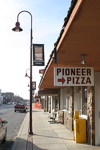
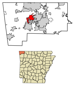
Gentry is a city in Benton County, Arkansas, United States. The population was 3,790 as of the 2020 census. The city was founded in the Ozark Mountains in 1894 along what would become the Kansas City Southern Railroad. The city's prior prosperity in the orchard industry, especially apples, was further strengthened by the rail connection. Following the decline of the apple industry in the 1930s, Gentry shifted its economy towards poultry along with many other areas of Northwest Arkansas.

El Paso is an unincorporated community and census-designated place (CDP) in southwestern White County, Arkansas, United States. It was first listed as a CDP in the 2020 census with a population of 267. Its name is Spanish for "the pass", referring to a small gap in the hills on the community's northern edge. Once known as Peach Orchard Gap in its early settlement, the origin of El Paso's Spanish name is unknown.

Highway 28 is designation for three east–west state highways in Western Arkansas. Two segments together running from the Oklahoma state line to Ola have been established since the original 1926 Arkansas state highway numbering, with the third segment designated in 1963. All three highways are rural, two-lane roads with relatively low traffic serving a sparsely populated and forested part of Arkansas. The highways are maintained by the Arkansas Department of Transportation (ARDOT).

Brightwater is a community in Benton County, Arkansas, United States. It is the location of Springfield to the Fayetteville Road-Brightwater Segment, which is located at N Old Wire Road/Benton Cty Rd. 67, south of US 62 and is listed on the National Register of Historic Places.

Cherokee City is an unincorporated census-designated place (CDP) in Benton County, Arkansas, United States. Per the 2020 census, the population was 73. It is the location of Coon Creek Bridge, which is located on Cty Rd. 24 and is listed on the National Register of Historic Places. The community was named for the Cherokee, since the Trail of Tears crossed the landscape when the Cherokee migrated west to Indian territory, now Oklahoma in the late 1830s. The town is within the Northwest Arkansas region, located about 5 miles east of Oklahoma and 4 miles south of the Missouri state line.
Hiwasse was an unincorporated community and census-designated place in Benton County, Arkansas, United States. As of the 2010 census, its population was 497. It is the location of Hiwasse Bank Building, which is located at Main St., AR 279 and Banks House, which is located on AR 72 west of Hiwasse. Both are listed on the National Register of Historic Places.
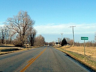
Maysville is an unincorporated community and census-designated place (CDP) in Benton County, Arkansas, United States. It is the westernmost settlement in the state of Arkansas. Per the 2020 census, the population was 117. It is located in the Northwest Arkansas region.

War Eagle is an unincorporated community in Benton County, Arkansas, United States. It is the location of War Eagle Bridge, which carries CR 98 over War Eagle Creek and is listed on the National Register of Historic Places.

Old High Middle School is a public middle school in Bentonville, Arkansas, part of the Bentonville Public Schools. Its building was once home to Bentonville High School. It was designed by John Parks Almand. It combines Spanish Colonial, Mission, and Mediterranean styles. Construction costs during building in 1928 were $25,000.

Gann Row Historic District is a historic district in Benton, Arkansas. The district includes thirteen residences built for Benton's middle-class population. Dr. Dewell Gan Sr., purchased most of the land in the district around 1890 and is responsible for building most of the homes. Four Folk Victorian homes in the district were built between 1880 and 1890; Gann renovated these in the 1920s, adding Craftsman details. Gann also built the remaining houses in the district in the 1920s; these were also designed in the Craftsman style. The district is still considered a middle-class residential area; it is bordered on three sides by other working-class housing and to the north by downtown Benton. It was listed on the National Register of Historic Places (NRHP) in 1999.
Durham is an unincorporated community in eastern Washington County, Arkansas, United States. The community is on Arkansas Highway 16 along the White River valley between Elkins to the northwest and Thompson in Madison County to the southeast. Its elevation is 1,247 feet (380 m).

This is a list of the National Register of Historic Places listings in Benton County, Arkansas.

Highway 190 is a designation for four state highways in Arkansas. Three are low-traffic rural highways in Grant County, with one designation along city streets in Pine Bluff. The rural segments were created in 1965 and 1966, with the Pine Bluff section created in 2000 as a renumbering of Highway 104. All segments are maintained by the Arkansas Department of Transportation (ARDOT).

Norwood is an unincorporated community in Township 13, Benton County, Arkansas, United States. It is located is south Benton County near the Washington County line on Arkansas Highway 16. The community had a school which is now closed and listed on the National Register of Historic Places.
The Norwood School is a historic school building on Old Norwood Church Road near the unincorporated community of Norwood in south Benton County, Arkansas. It is a modest single-story stone building, fashioned out of rough-cut local fieldstone, topped by a hip roof with exposed rafter ends. A pair of entrances are sheltered by a gabled portico supported by a stone arch. It was built by the Works Progress Administration in 1937, and is the only building of its type in Benton County. The property also includes an original stone outhouse.
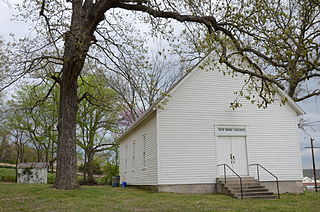
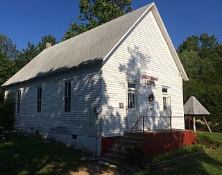
The New Home School and Church is a historic community building on McKisic Creek Road south of Bella Vista, Arkansas. It is a modest single-story wood-frame structure, with a gable roof, which lacks ornamentation. Its main facade has a double-door entrance, and the side facades have three bays of windows. Built c. 1900, it is a well-preserved example of a multifunction vernacular community building, which was used as a school during the week and as a church on Sundays. The school function was discontinued after schools in the area were consolidated.

The Coal Gap School is a historic school building located near Garfield, Arkansas. The wood-frame school was built in 1928 to serve Benton County School District 105. The school served the rural area around the Glade community; it was built during a period of economic transition for the area, which had historically been an orchard farming community but was turning to grain farming and animal husbandry. In the 1960s, the creation of Beaver Lake separated the school from areas across the White River.
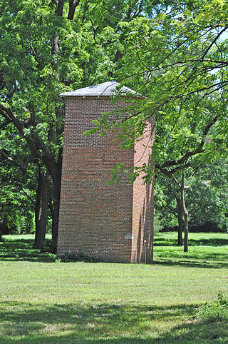
The Breedlove House and Water Tower are a historic residential property on the south side Benton County Route 4 east of Bentonville, Arkansas, about 1.1 miles (1.8 km) east of its junction with Arkansas Highway 72. The two-story house is a c. 1887 brick structure that was enlarged and restyled c. 1907, giving it a mix of original Italianate and Eastlake detailing, and a front Colonial Revival two-story porch. The property includes a 28-foot (8.5 m) square brick tower, built c. 1920 as a water supply for an apple orchard. The tower is the only structure surviving in the county from the period known to be associated with the then-significant apple industry.
The Rocky Branch School is a historic school building in rural eastern Benton County, Arkansas. It is located at the northern terminus of Arkansas Highway 303, where it joins with County Roads 85 and 99, and stands opposite the Rocky Branch Church. It is a one-room schoolhouse, with two doors facing east. The school was built c. 1914 in the community of La Rue, and was moved to its present site c. 1960 when that community was inundated by the creation of nearby Beaver Lake. It is a well-preserved example of a country district schoolhouse, with little alteration since its construction.


