Luten Bridge Company and variations such as Luten Engineering Company was the name of a number of different bridge building companies in the United States during the early- to mid-20th century. Each had rights to build concrete Luten arch bridges, according to the patented designs of Daniel B. Luten, of Indianapolis.

The Cane Hill Road Bridge was a closed-spandrel arch bridge built in 1923 located near Prairie Grove, Arkansas. It carried Arkansas Highway 170 over the Little Red River, and was in 2014 in the process of being bypassed. The bridge has a single span about 43 feet (13 m) in length, with an overall bridge length of 48 feet (15 m). The bridge is 15 feet (4.6 m) wide. AR 170 was the major north–south route in the area when the bridge was built, but this section has since been bypassed by the construction of United States Route 62. The bridge was built by the Luten Bridge Company of Knoxville, Tennessee.

The F Street Bridge in Salida, Colorado is a closed spandrel concrete arch bridge built in 1907 by the Pueblo Bridge Company. The design also known as a Luten Arch bridge was patented in 1907 by Daniel Luten. The bridge has two spans each with length of 60 feet (18 m), and 128 feet (39 m) in total. It is believed to be the first bridge of this type built by the company.
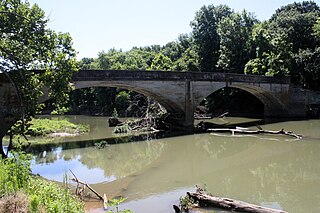
The Illinois River Bridge, also known as the Midway Bridge, is a historic concrete arch bridge near Siloam Springs, Arkansas. It is located in Ozark National Forest, about 6 miles (9.7 km) east of Siloam Springs, at the end of Chambers Springs Road south of United States Route 412. The bridge has two elliptical arch spans, each spanning 68 feet (21 m), with a total structure length of 139 feet (42 m). Built in 1922 by the Luten Bridge Company of Knoxville, Tennessee, it is one of a modest number of bridges of this once-popular and common type remaining in the state.

The Twin Bridges Historic District, in Washington County, Arkansas, near Morrow, is an area surrounding two closed-spandrel, concrete-deck bridges completed in 1922 by the Luten Bridge Company. These bridges are located on County Route 3412 and former County Route 11. The district was added to the National Register of Historic Places on March 7, 1994.
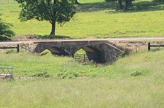
The Calamus Creek Bridge near Maxwell, Iowa is a concrete Luten arch bridge constructed in 1905. It was built by N. M. Stark and Company for a cost of $900. It has a 25-foot (7.6 m) single span and a total length of 45 feet (14 m).

The White River Bridge in Elkins, Arkansas is a historic structure carrying County Road 44 over the White River in eastern Washington County. The bridge is a patented closed-spandrel arch design called the Luten arch, owned by the Luten Bridge Company of Knoxville, Tennessee, which emphasized strengthened piers and abutments, resulting in a reduced need for material. This bridge has three arches, with a total length of 192 feet (59 m). After construction in 1921, farmers in southeast Washington County were better able to bring their products to market in Elkins.
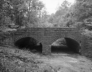
The Mulladay Hollow Bridge is a stone arch bridge in rural Carroll County, Arkansas. It carries County Road 204 across Mulladay Hollow Creek, near the southwestern tip of Lake Leatherwood It has two spans, and is built out of roughly square and semi-coursed fieldstone. The arches are elliptical in shape, 9 feet (2.7 m) in height and 9.5 feet (2.9 m) wide, with nearly-square voussoirs forming the arches. The barrels of the arches are skewed with respect to the spandrels, and the wing walls are slightly curved. The roadway carried by the bridge is 30 feet (9.1 m) wide, and the total length of the structure is 120 feet (37 m). The bridge was built with Works Progress Administration funding as part of the development of Lake Leatherwood as a recreation area.

The Highway B-29 Bridge is a historic bridge in Prairie Grove, Arkansas. It is a single-span concrete arch bridge, carrying Washington County Route 623 across the Illinois River. The arch has a span of 97 feet (30 m), and the total structure length is 100 feet (30 m). Its deck is 17 feet (5.2 m) wide, and the bridge is typically 20 feet (6.1 m) above the water. Built in 1923, the bridge is one of the first built in the county by the Luten Bridge Company, which used an innovative technique involving metal rings that reduced the amount of material required for the structure.

The Illinois River Bridge at Phillips Ford is a historic bridge in rural northern Washington County, Arkansas. It is a double-span closed-spandrel concrete arch bridge built in 1928 by the Luten Bridge Company, and it carries County Road 848 across the Illinois River in the Ozark National Forest south of U.S. Route 412 (US 412). The bridge's arches each span 81 feet (25 m), and the total structure length is 168 feet (51 m). The bridge uses Luten's patented method of reducing material in the bridge by the addition of metal rings to the spandrel walls.

The Milltown Bridge is a historic stone arch bridge in rural southeastern Sebastian County, Arkansas. The bridge carries County Road 77 across an unnamed brook just west of its junction with White Mountain Road. It is a two-span closed spandrel structure, with each arch spanning 10 feet (3.0 m) and a total length of 24 feet (7.3 m). The arches are formed out of rough-cut stone voussoirs. It was built in the 1930s with funding from the Works Progress Administration, and was, when listed on the National Register of Historic Places in 1990, one of only eight documented bridges of its type in the state. The bridge was delisted from the register in 2002.
The Cedar Creek Bridge is a historic bridge in rural southern Independence County, Arkansas. It is located on Goodie Creek Road, about 1.5 miles (2.4 km) south of its junction with Arkansas Highway 14. It is a two-span stone masonry structure, spanning Cedar Creek, a tributary to the White River, with two closed-spandrel arches having a total length of 30 feet (9.1 m). Its deck is 24.1 feet (7.3 m) wide, with a total structure width of 26.1 feet (8.0 m), including the parapets at the sides. The bridge was built 1941, and was probably designed by an engineer of the state's highway department.

The Central Avenue Bridge is a historic bridge in Batesville, Arkansas. It carries AR 69B and Central Avenue across Poke Bayou on the city's west side. It is an open spandrel concrete structure, with five spans having a total length of 397 feet (121 m). The longest single span is 80 feet (24 m). The bridge was built in 1930 by the Luten Bridge Company, and features that company's signature rings in the spandrels, which provide additional strength with a minimal use of additional material.

The Harp Creek Bridge is a historic bridge in rural northern Newton County, Arkansas, carrying Arkansas Highway 7 across Harp Creek in the hamlet of Harrison. It is an open-spandrel arch bridge, built out of reinforced concrete in 1928 by the Luten Bridge Company. The arches span 69 feet (21 m), and are mounted on piers set 24 feet (7.3 m) from the abutments. The total structure length is 117 feet (36 m), and the deck is 23 feet (7.0 m) wide. Concrete balustrades line the sides of the bridge.
The War Eagle Creek Bridge is a historic bridge in northern Madison County, Arkansas. It carries County Road 1650 across War Eagle Creek northeast of Huntsville, and just north of creek crossing of United States Route 412. The bridge is a two-span open-spandrel concrete arch bridge, with a total length of 206 feet (63 m). Each arch spans 70 feet (21 m), and they are mounted on concrete abutments and a central pier. Built in 1925–26, it is the county's only known surviving example of this bridge type.

The South Fork Bridge is a historic bridge spanning the South Fork Saline River in Fountain Lake, Arkansas. It formerly carried Arkansas Highway 128, whose modern bridge now stands just to the south, a short way east of its junction with Arkansas Highway 5. It is a two-span concrete closed-spandrel arch structure, with spans of 57 feet (17 m) and a roadway width of 16 feet (4.9 m). It was built in 1928 by a county crew, after major flooding in 1927 damaged road infrastructure in the area.

The Lake No. 1 Bridge is a historic bridge carrying Avondale Road across the northern tip of Lake Number 1 in North Little Rock, Arkansas. It is a closed-spandrel stone arch bridge with Rustic styling, built in the 1920s as part of the Lakewood development promoted by developer Justin Mathews. It has a single elliptical arch, spanning 18 feet (5.5 m), with a total structure length of 30 feet (9.1 m). It was one of eight stone arch bridges built in the state between 1923 and 1939, and one of the few that was privately built.

The Fourche LaFave River Bridge carries Arkansas Highway 7 across the Fourche LaFave River in western Perry County, Arkansas, downstream of the Nimrod Dam. It is a three-span open spandrel concrete arch bridge, with its longest span measuring 184 feet (56 m), and its total length 518 feet (158 m). The arches are mounted on concrete abutments and piers. The bridge deck is asphalt, and is lined by ornate concrete balustrades. It was built in 1941 by the Luten Bridge Company, and is a well-preserved example of style from that period.
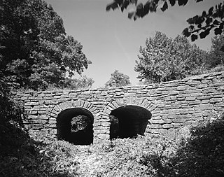
The Spring Lake Bridge is a historic bridge in the eastern part of Ozark-St. Francis National Forest, carrying County Road 35 across an inlet of Spring Lake known as Bob Barnes Branch, in the Spring Lake Recreation Area with the Ozark–St. Francis National Forest. It is a two-span closed-spandrel stone arch bridge with a total length of 36 feet (11 m). Each arch is 10 feet (3.0 m) long and 6 feet (1.8 m) high. Built in 1936 with federal funding, it is one of the state's finest examples of a stone arch bridge.

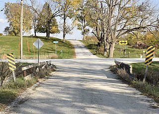
Keigley Branch Bridge is a historic structure located northeast of Gilbert, Iowa, United States. It spans the Keigley Branch for 47 feet (14 m). The Iowa State Highway Commission was re-formed in 1913 and they developed standard designs for smaller bridges. One of their designs was an alternative to the Luten arch. They were built throughout the state in the 1910s and 1920s. This is the oldest remaining arch bridge from that era. The Koss Construction Company of Des Moines completed it in 1913 for $3,384.85. The bridge features a medium-span arch with concrete-filled spandrels, paneled guardrails, a corbeled arch ring, and two-tone concrete detailing. The Keigley Branch Bridge was listed on the National Register of Historic Places in 1998.


