Marion County is located in the Ozark Mountains in the U.S. state of Arkansas. The county is named for Francis Marion, the famous "Swamp Fox" of the Revolutionary War. Created as Arkansas's 35th county in 1836, Marion County is home to one incorporated town and four incorporated cities, including Yellville, the county seat. The county is also the site of numerous unincorporated communities and ghost towns. The county included part of what is now Searcy County, Arkansas, with many opposing to dividing them, which helped fueled the bloody Tutt-Everett War between 1844 and 1850.

Pyatt is a town in western Marion County, Arkansas, United States. The population was 181 at the 2020 census, down from 221 in 2010.

Highway 16 is an east–west state highway in Arkansas. The route begins in Siloam Springs at US Highway 412 (US 412) and Highway 59 and runs east through Fayetteville and the Ozark National Forest to US Highway 67 Business (US 67B) in Searcy. Highway 16 was created during the 1926 Arkansas state highway numbering, and today serves as a narrow, winding, 2-lane road except for overlaps of 10 miles (16 km) through Fayetteville. Much of the highway winds through the Ozarks, including the Ozark National Forest, where a portion of the highway is designated as an Arkansas Scenic Byway. The route has two spur routes in Northwest Arkansas; in Fayetteville and Siloam Springs.

The Cotter Bridge, also known as the R. M. Ruthven Bridge and the White River Concrete Arch Bridge, carries U.S. Route 62 Business across the White River west of the city of Cotter in Baxter County, Arkansas. Upon completion, the bridge opened a part of the Ozarks previously inaccessible to motorists. Constructed in 1930, it is the only bridge built by the Marsh Engineering Company of Des Moines, Iowa, in the state of Arkansas.

U.S. Route 64 is a U.S. highway running from Teec Nos Pos, Arizona east to Nags Head, North Carolina. In the U.S. state of Arkansas, the route runs 246.35 miles (396.46 km) from the Oklahoma border in Fort Smith east to the Tennessee border in Memphis. The route passes through several cities and towns, including Fort Smith, Clarksville, Russellville, Conway, Searcy, and West Memphis. US 64 runs parallel to Interstate 40 until Conway, when I-40 takes a more southerly route.

Highway 14 is an east–west state highway in Arkansas. The route of 227.35 miles (365.88 km) begins at Boat Dock Road near Table Rock Lake and runs east to Mississippi County Route W1020 (CR W1020) at Golden Lake. Segments of the highway are part of two Arkansas Scenic Byways: Sylamore Scenic Byway in the Ozark National Forest and the Crowley's Ridge Parkway atop Crowley's Ridge.
The Chicago Drive Bridge, also known as the Business Route M-21–Plaster Creek Bridge, is a bridge in Wyoming, Michigan, carrying Business Spur I-196 over Plaster Creek. It was listed on the National Register of Historic Places in 1999.

U.S. Route 62 is a U.S. highway running from El Paso, Texas northeast to Niagara Falls, New York. In the U.S. state of Arkansas, the route runs 329.9 miles from the Oklahoma border near Summers east to the Missouri border in St. Francis, serving the northern portion of the state. The route passes through several cities and towns, including Fayetteville, Springdale, Bentonville, Harrison, Mountain Home, Pocahontas, and also Piggott. US 62 runs concurrent with several highways in Arkansas including Interstate 49 and U.S. Route 71 between Fayetteville and Bentonville, U.S. Route 412 through much of the state, U.S. Route 65 in the Harrison area, and with U.S. Route 63 and U.S. Route 67 in northeast Arkansas.

The Zion – Mount Carmel Highway is a 25-mile (40 km) long road in Washington and Kane counties in southern Utah, United States, that is listed on the National Register of Historic Places and is a National Historic Civil Engineering Landmark.
Sixteen special routes of U.S. Route 62 currently exist. Seven of them lie within the state of Arkansas. Three existed in the past but have since been decommissioned.
The White River Bridge is a five span Warren deck truss bridge located near Beaver, Carroll County, Arkansas. It carries U.S. Route 62 over the White River for 786.90 feet (239.85 m). Each span is about 128 feet (39 m) in length, and is mounted on concrete piers or abutments. The bridge was built in 1950-52 by the Forcum-James Company of Dyersburg, Tennessee. It was the last of eleven deck-truss bridges built in the state, and is the only one of its type in the county.

The Perkiomen Bridge, originally built 1798-99 and widened in 1928, is one of the oldest stone arch bridges in the United States still in use. It crosses Perkiomen Creek near Collegeville, Pennsylvania. The bridge's six semi-circular arches cover a total of over 300 feet (91 m). The longest arch spans 76 feet (23 m). Its decorative piers and belts courses are unusual for a bridge this old. A lottery financed $20,000 of the original construction. The bridge carried the main road from Philadelphia to Reading, known at various times as the Manatawny Pike, Germantown Pike, the Philadelphia-Reading Pike, and US 422. Since the construction of the US 422 bypass, the road has been known as Ridge Pike or Old US 422.

U.S. Highway 71 is a U.S. highway that runs from Krotz Springs, LA to the Fort Frances–International Falls International Bridge at the Canadian border. In Arkansas, the highway runs from the Louisiana state line near Doddridge to the Missouri state line near Bella Vista. In Texarkana, the highway runs along State Line Avenue with US 59 and partially runs in Texas. Other areas served by the highway include Fort Smith and Northwest Arkansas.

Ciénega Bridge is an open-spandrel arch bridge which crosses Ciénega Creek and the Union Pacific Railroad near Vail, Arizona. Originally constructed in 1921, the bridge was part of U.S. Route 80, a major transcontinental highway, from 1926 to 1956. Being the oldest bridge of its kind in Arizona, the Ciénega Bridge is listed on the National Register of Historic Places. Currently, the bridge carries Marsh Station Road.
The Marr's Creek Bridge is a historic bridge spanning Marr's Creek in Pocahontas, Arkansas. The concrete open spandrel deck arch bridge formerly carried U.S. Route 67 (US 67), which now passes over the creek on an adjacent modern steel and concrete structure. When built in 1934 by the Public Works Administration, the bridge had a total length of 135 feet (41 m), with six spans, including the main arch across the creek. The bridge was widened slightly at its eastern end in 1950 to accommodate a slight curve.
The Pyatt Tunnel is a historic railroad tunnel in Marion County, Arkansas. It is a 660-foot (200 m) tunnel, hewn through bedrock beneath a ridge north of Crooked Creek and southeast of the city of Pyatt. The tunnel's portals are unimproved, and the tunnel itself has no concrete reinforcement, unlike other tunnels on the White Mountain Division of the Missouri Pacific Railroad, which passes through it. The tunnel was built in 1903–1904, and is one of seven railroad tunnels in the state.
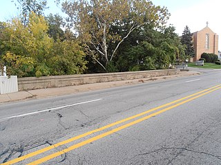
The US 62 Bridge over Crooked Creek is a historic bridge near Pyatt, Arkansas. It carries US Highway 62 (US 62) and US 412 across Crooked Creek, which flows through the center of Pyatt to the northwest.
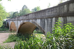
The War Eagle Creek Bridge is a historic bridge in northern Madison County, Arkansas. It carries County Road 1650 across War Eagle Creek northeast of Huntsville, and just north of creek crossing of United States Route 412. The bridge is a two-span open-spandrel concrete arch bridge, with a total length of 206 feet (63 m). Each arch spans 70 feet (21 m), and they are mounted on concrete abutments and a central pier. Built in 1925–26, it is the county's only known surviving example of this bridge type.

Highway 51 is a designation for two north–south state highways in Southwest Arkansas. One route of 53.37 miles (85.89 km) begins Highway 53 near Whelen Springs and runs north to US Highway 67 in Donaldson. A second route of 7.92 miles (12.75 km) runs parallel to US 270 northwest of Malvern. Both routes are maintained by the Arkansas Department of Transportation (ArDOT).
The Pine Bluff Arsenal Access Road Bridge No. 2280 is a historic bridge near White Hall, Arkansas. It carries East Hoadley Road over Caney Creek, between the town and the Pine Bluff Arsenal. It is a concrete arch structure, with a total length of 152 feet (46 m). It consists of a concrete deck supported by abutments and four cast concrete piers, carrying a roadway 28 feet (8.5 m) in width. It was built in 1942 with funds authorized by the National Defense Highway Act of 1941, in order to facilitate access between the arsenal and existing transportation networks.