Luten Bridge Company and variations such as Luten Engineering Company was the name of a number of different bridge building companies in the United States during the early- to mid-20th century. Each had rights to build concrete Luten arch bridges, according to the patented designs of Daniel B. Luten, of Indianapolis.

The Albertus L. Meyers Bridge, also known as the Eighth Street Bridge, the South Eighth Street Viaduct, and unsigned as SR 2055, is a reinforced concrete open-spandrel arch bridge located in Allentown, Pennsylvania. The bridge is "one of the earliest surviving examples of monumental, reinforced concrete construction," according to the American Society of Civil Engineers.

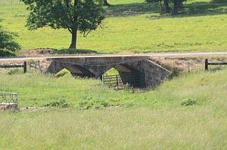
The Davies Bridge carries Red Bluff Drive across Cedar Creek, just north of Arkansas Highway 154 in Petit Jean State Park, Arkansas. It is a single-span closed-spandrel masonry arch structure, with an arch 20 feet (6.1 m) long and 10 feet (3.0 m) high. It is built out of mortared ashlar fieldstone laid in courses, with some stones left rusticated and protruding from the sides. The bridge was built in 1934 by a crew of the Civilian Conservation Corps that was developing the park's facilities.

The Cove Creek Bridge is a historic bridge, carrying Arkansas Highway 309 across Cove Creek, south of the hamlet of Corley, Arkansas in the Ozark-St. Francis National Forest. It is a two-span closed-spandrel masonry arch structure, with each span measuring 13 feet (4.0 m) and an overall structure length of 26 feet (7.9 m). It is built entirely out of stone, with a concrete and asphalt deck, and concrete barriers at the sides. It was built in 1936 with funding support from the Works Progress Administration.

The Cane Hill Road Bridge was a closed-spandrel arch bridge built in 1923 located near Prairie Grove, Arkansas. It carried Arkansas Highway 170 over the Little Red River, and was in 2014 in the process of being bypassed. The bridge has a single span about 43 feet (13 m) in length, with an overall bridge length of 48 feet (15 m). The bridge is 15 feet (4.6 m) wide. AR 170 was the major north–south route in the area when the bridge was built, but this section has since been bypassed by the construction of United States Route 62. The bridge was built by the Luten Bridge Company of Knoxville, Tennessee.
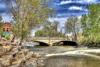
The F Street Bridge in Salida, Colorado is a closed spandrel concrete arch bridge built in 1907 by the Pueblo Bridge Company. The design also known as a Luten Arch bridge was patented in 1907 by Daniel Luten. The bridge has two spans each with length of 60 feet (18 m), and 128 feet (39 m) in total. It is believed to be the first bridge of this type built by the company.
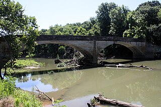
The Illinois River Bridge, also known as the Midway Bridge, is a historic concrete arch bridge near Siloam Springs, Arkansas. It is located in Ozark National Forest, about 6 miles (9.7 km) east of Siloam Springs, at the end of Chambers Springs Road south of United States Route 412. The bridge has two elliptical arch spans, each spanning 68 feet (21 m), with a total structure length of 139 feet (42 m). Built in 1922 by the Luten Bridge Company of Knoxville, Tennessee, it is one of a modest number of bridges of this once-popular and common type remaining in the state.

The Marr's Creek Bridge is a historic bridge spanning Marr's Creek in Pocahontas, Arkansas. The concrete open spandrel deck arch bridge formerly carried U.S. Route 67 (US 67), which now passes over the creek on an adjacent modern steel and concrete structure. When built in 1934 by the Public Works Administration, the bridge had a total length of 135 feet (41 m), with six spans, including the main arch across the creek. The bridge was widened slightly at its eastern end in 1950 to accommodate a slight curve.

The Evansville-Dutch Mills Road Bridge is a historic bridge in rural western Washington County, Arkansas. It is a single-span concrete filled-spandrel arch bridge, which carries Dutch Mills Road over Whitaker Branch South south of the village of Dutch Mills The bridge was built in 1936 by the Luten Bridge Company, and was one of its last commissions in the county. The arch spans 28 feet (8.5 m) and the bridge has a total structure length of 30 feet (9.1 m). The bridge was built with a unique Luten Company design that used rings to strengthen the connection between the piers and spandrel walls, enabling a reduced amount of material while maintaining the strength of the bridge.

The Highway B-29 Bridge is a historic bridge in Prairie Grove, Arkansas. It is a single-span concrete arch bridge, carrying Washington County Route 623 across the Illinois River. The arch has a span of 97 feet (30 m), and the total structure length is 100 feet (30 m). Its deck is 17 feet (5.2 m) wide, and the bridge is typically 20 feet (6.1 m) above the water. Built in 1923, the bridge is one of the first built in the county by the Luten Bridge Company, which used an innovative technique involving metal rings that reduced the amount of material required for the structure.

The Illinois River Bridge at Phillips Ford is a historic bridge in rural northern Washington County, Arkansas. It is a double-span closed-spandrel concrete arch bridge built in 1928 by the Luten Bridge Company, and it carries County Road 848 across the Illinois River in the Ozark National Forest south of U.S. Route 412 (US 412). The bridge's arches each span 81 feet (25 m), and the total structure length is 168 feet (51 m). The bridge uses Luten's patented method of reducing material in the bridge by the addition of metal rings to the spandrel walls.

The Mountain Fork Bridge is a historic bridge in rural Polk County, Arkansas. It carries County Road 38 across Mountain Fork River north of Hatfield and southwest of Mena. The bridge consists of two spans of steel Pratt pony trusses, with a total length of 406 feet (124 m), including approach spans. The trusses are set on piers consisting of steel rings filled with concrete; each of these spans is 80 feet (24 m) long. The bridge's construction date and builder are unknown; it predates the standardization of bridge designs in the state in 1923. It is estimated to date to the early 1900s.

The Edgemere Street Bridge is a historic bridge in North Little Rock, Arkansas. It carries Edgemere Street over a small part of Lakewood Lake Number Three. It is a masonry structure with closed spandrels, and has a span of about 18 feet (5.5 m) and a total length of 57 feet (17 m). It is built out of rustic, roughly squared fieldstone, that is laid in uncoursed fashion. Vertical columns project from either side of the spandrels, rising above the deck level to form a decorative parapet. It was built, along with the similar Lakeshore Drive Bridge as part of the innovative Lakewood Development project of developer Justin Matthews in the 1930s.
The Cedar Creek Bridge is a historic bridge in rural southern Independence County, Arkansas. It is located on Goodie Creek Road, about 1.5 miles (2.4 km) south of its junction with Arkansas Highway 14. It is a two-span stone masonry structure, spanning Cedar Creek, a tributary to the White River, with two closed-spandrel arches having a total length of 30 feet (9.1 m). Its deck is 24.1 feet (7.3 m) wide, with a total structure width of 26.1 feet (8.0 m), including the parapets at the sides. The bridge was built 1941, and was probably designed by an engineer of the state's highway department.

The Central Avenue Bridge is a historic bridge in Batesville, Arkansas. It carries AR 69B and Central Avenue across Poke Bayou on the city's west side. It is an open spandrel concrete structure, with five spans having a total length of 397 feet (121 m). The longest single span is 80 feet (24 m). The bridge was built in 1930 by the Luten Bridge Company, and features that company's signature rings in the spandrels, which provide additional strength with a minimal use of additional material.

The Harp Creek Bridge is a historic bridge in rural northern Newton County, Arkansas, carrying Arkansas Highway 7 across Harp Creek in the hamlet of Harrison. It is an open-spandrel arch bridge, built out of reinforced concrete in 1928 by the Luten Bridge Company. The arches span 69 feet (21 m), and are mounted on piers set 24 feet (7.3 m) from the abutments. The total structure length is 117 feet (36 m), and the deck is 23 feet (7.0 m) wide. Concrete balustrades line the sides of the bridge.

The South Fork Bridge is a historic bridge spanning the South Fork Saline River in Fountain Lake, Arkansas. It formerly carried Arkansas Highway 128, whose modern bridge now stands just to the south, a short way east of its junction with Arkansas Highway 5. It is a two-span concrete closed-spandrel arch structure, with spans of 57 feet (17 m) and a roadway width of 16 feet (4.9 m). It was built in 1928 by a county crew, after major flooding in 1927 damaged road infrastructure in the area.

The Middle Fork of the Little Red River Bridge, also known as the Shirley Railroad Bridge, is a historic bridge in Shirley, Arkansas. It is a single-span iron Baltimore through truss, with a main span 153 feet (47 m) long, and steel beam approach spans giving it a total length of 339 feet (103 m). The main span rests on large concrete piers set in the river. The bridge was built in 1908 for the Missouri and North Arkansas Railroad, and carried the railroad until 1949. In 1978 the tracks were covered by a concrete deck, and the bridge was converted to single-lane vehicular road use, carrying County Road 125.

The Fourche LaFave River Bridge carries Arkansas Highway 7 across the Fourche LaFave River in western Perry County, Arkansas, downstream of the Nimrod Dam. It is a three-span open spandrel concrete arch bridge, with its longest span measuring 184 feet (56 m), and its total length 518 feet (158 m). The arches are mounted on concrete abutments and piers. The bridge deck is asphalt, and is lined by ornate concrete balustrades. It was built in 1941 by the Luten Bridge Company, and is a well-preserved example of style from that period.

The Cove Creek Tributary Bridge is a historic bridge in rural Logan County, Arkansas. It is a two-span closed-spandrel stone arch bridge, carrying Arkansas Highway 309 across a tributary of Cove Creek north of Corley in Ozark-St. Francis National Forest. Each of its arches is 11 feet (3.4 m) long, and the structure is an overall 23 feet (7.0 m) in length. Concrete barriers form the sides of the bridge on either side of the roadway. The bridge was built in 1936 under the auspices of the Arkansas Highway Commission.


