East Nantmeal Township is a township in Chester County, Pennsylvania, United States. The population was 1,803 at the 2010 census. Along with West Nantmeal Township, it was originally part of a single Nantmeal Township, which was divided in 1739.

Concord Township is a township in Delaware County, Pennsylvania, United States. The population was 17,231 at the 2010 census. It contains the unincorporated communities of Concordville and Glen Mills.

Whitemarsh Township is a Home rule municipality in Montgomery County, Pennsylvania. It retains its former classification of "Township" in its official name despite being a home rule municipality. The population was 17,349 at the 2010 census. Whitemarsh is adjacent to the neighborhood of Andorra in the Roxborough section of Philadelphia, and is bordered in Montgomery County by Springfield, Upper Dublin, Whitpain, and Plymouth townships, Conshohocken, and the Schuylkill River, which separates it from Lower Merion Township.
Penn Township is a township in Westmoreland County, Pennsylvania, United States.

Chestnut Hill is a neighborhood in the Northwest Philadelphia section of Philadelphia, Pennsylvania, United States. It is known for the high incomes of its residents and high real estate values, as well as its private schools.

Fox Chase is a neighborhood in Northeast Philadelphia, Pennsylvania, United States, neighbouring Oxford Circle and Rhawnhurst.
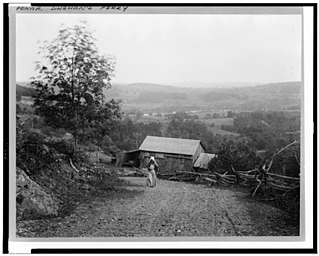
Dingmans Ferry is an unincorporated community in Delaware Township, Pike County, Pennsylvania, United States. As of 2014, it had a population of 7,477 people. It was originally sited on the Delaware River, in an area now included in the Delaware Water Gap National Recreation Area. When the Corps of Engineers acquired the land by eminent domain in the mid-twentieth century for the creation of the proposed Tocks Island Dam project, it relocated the community further up the hill.

This is a list of properties and districts listed on the National Register of Historic Places in Pennsylvania. As of 2015, there are over 3,000 listed sites in Pennsylvania. All 67 counties in Pennsylvania have listings on the National Register.
Girard Estate, also known as Girard Estates, is part of South Philadelphia, Pennsylvania, United States. Its boundaries stretch from South 22nd Street on the west to South 17th Street on the east. The southern boundary is clearly defined as the south side of Shunk Street, but its northern boundary is irregular in stretching from the north side of Porter Street between South 17th Street and South 21st Streets, along the east side of South 21st Street to West Passyunk Avenue, then along the south side of West Passyunk Avenue to its northwestern tip at South 22nd Street. It is named after Stephen Girard, whose South Philadelphia property was developed in the 1920s by the City of Philadelphia.

Imlaystown is an unincorporated community located along County Route 43 and Davis Station Road within Upper Freehold Township in Monmouth County in the U.S. state of New Jersey. It is located in ZIP code 08526. The community is accessible from Exit 11 of Interstate 195.

Kooser State Park is a 250-acre (101 ha) Pennsylvania state park in Jefferson Township, Somerset County, Pennsylvania, in the United States. The park, which borders Forbes State Forest, was built in the 1930s by the Civilian Conservation Corps, who also built the 4-acre (1.6 ha) Kooser Lake by damming Kooser Run. Kooser State Park is on Pennsylvania Route 31 a one-hour drive from Pittsburgh. The park is surrounded by Forbes State Forest.

Huntingdon Valley is a village, as well as a suburban mailing address located in Lower Moreland Township, Upper Moreland Township and Abington Township all in Montgomery County, and in small sections of Upper Southampton Township and Lower Southampton Township in Bucks County, Pennsylvania, United States, bordering the Fox Chase, Bustleton, and Somerton sections of Philadelphia.

The Hudson River Historic District, also known as Hudson River Heritage Historic District, is the largest Federally designated district on the mainland of the contiguous United States. It covers an area of 22,205 acres extending inland roughly a mile (1.6 km) from the east bank of the Hudson River between Staatsburg and Germantown in Dutchess and Columbia counties in the U.S. state of New York. This area includes the riverfront sections of the towns of Clermont, Red Hook, Rhinebeck and part of Hyde Park. This strip includes in their entirety the hamlets of Annandale, Barrytown, Rhinecliff and the village of Tivoli. Bard College and two protected areas, Margaret Lewis Norrie State Park and Tivoli Bays Unique Area, are also within the district.
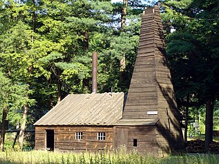
The Drake Well is a 69.5-foot-deep (21.2 m) oil well in Cherrytree Township, Venango County in the U.S. state of Pennsylvania, the success of which sparked the first oil boom in the United States. The well is the centerpiece of the Drake Well Museum located 3 miles (5 km) south of Titusville.
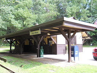
Fetter's Mill Village Historic District is a national historic district located in Bryn Athyn and Lower Moreland Township, Montgomery County, Pennsylvania. It encompasses five contributing buildings and three contributing structures. They are a wagon shed / John Conner studio (1751), Alnwick Grove Train Station, Bryn Athyn Train Station / Post Office (1902), farmhouse, stone barn, two iron bridges, and a milk platform. Located in the district is the separately listed Fetter's Mill, built about 1740.

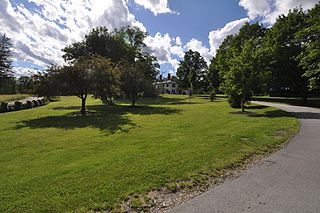
The George F. Tyler Mansion (1928–31), also known as "Indian Council Rock," is a French-Norman country house and former estate which is located in Newtown Township, Bucks County, Pennsylvania. Located west of Pennsylvania Route 413 and north of Pennsylvania Route 332, the property is now divided into Tyler State Park and the campus of Bucks County Community College.

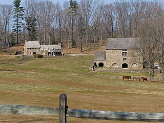
The Hopewell Farm, also known as Lower Farm and Hopedell Farm, is a historic home and farm located at 1751 Valley Road in Valley Township, Chester County, Pennsylvania. The 500-acre farm complex has six contributing buildings, one contributing site, and six contributing structures. The buildings and property were added to the National Register of Historic Places in 2010.
The Worth–Jefferis Rural Historic District is a national historic district that is located in East Bradford Township and West Bradford Township, Chester County, Pennsylvania.
The Dickinson Estate Historic District encompasses the core holding of an early 20th century country estate in rural northern Brattleboro, Vermont. It includes a sophisticated Colonial Revival mansion house, built in 1900, and a variety of agricultural outbuildings dating to the same period. The estate, and in particular its barnyard complex, are well-preserved remnants of this era. The property is also notable for its association with Rudyard Kipling, who owned the estate for several years. It was listed on the National Register of Historic Places in 2005. The district covers 30 acres (12 ha) of what is now the main campus of the World Learning organization, a larger subset of the original Dickinson Estate.

The Pleasant Lawn School Historic District is a nationally recognized historic district located northeast of Mount Pleasant, Iowa, United States. It was listed on the National Register of Historic Places in 1987. At the time of its nomination it consisted of three resources, all of which are contributing buildings. This is the only intact example of a consolidated rural school district in Iowa. It consists of a two-story brick school building (1917), a two-story frame teacherage (1917), and a hack barn. A gymnasium was added to the school building in 1941. The school was still in existence when the buildings were added to the National Register.

