
Lawrence County is a county located in the U.S. state of Arkansas. As of the 2020 census, the population was 16,216. The county seat is Walnut Ridge. Lawrence County is Arkansas's second county, formed on January 15, 1815, and named for Captain James Lawrence who fought in the War of 1812. It is an alcohol prohibition or dry county.

Greene County is a county located in the U.S. state of Arkansas. As of the 2020 census, the population was 45,736. The county seat is Paragould, which sits atop Crowley's Ridge. Greene County is included in Jonesboro–Paragould Combined Statistical Area.

U.S. Route 412 is an east–west United States highway, first commissioned in 1982. U.S. 412 overlaps expressway-grade Cimarron Turnpike from Tulsa west to Interstate 35 and the Cherokee Turnpike from 5 miles (8.0 km) east of Chouteau, Oklahoma, to 8 miles (13 km) west of the Arkansas state line. It runs the entire length of the Oklahoma Panhandle and traverses the Missouri Bootheel.

Arkansas Highway 25 is a north–south state highway in north central Arkansas. The route runs 127.36 miles (204.97 km) from Interstate 40 (I-40) in Conway north to US 63/US 412 in Black Rock through Heber Springs, Batesville, and the foothills of The Ozarks.
U.S. Highway 412 (US 412) runs east-to-west through northern Arkansas for about 290 miles (470 km). The route begins at the Oklahoma state line near Siloam Springs, and ends at the Missouri state line east of Paragould.

The Davies Bridge carries Red Bluff Drive across Cedar Creek, just north of Arkansas Highway 154 in Petit Jean State Park, Arkansas. It is a single-span closed-spandrel masonry arch structure, with an arch 20 feet (6.1 m) long and 10 feet (3.0 m) high. It is built out of mortared ashlar fieldstone laid in courses, with some stones left rusticated and protruding from the sides. The bridge was built in 1934 by a crew of the Civilian Conservation Corps that was developing the park's facilities.

The St. Francis River Bridge carries United States Route 70 over the St. Francis River near Madison in St. Francis County, Arkansas, United States. It consists of three Parker through trusses, each 162 feet (49 m) long, and a swing bridge span 230 feet (70 m) long. With approaches, the bridge has a total length of 921 feet (281 m). The swing span is mounted on a central pier, and is rotated by two workers operating a large hickory handle. The bridge was built in 1932–33, with the swing span design made to accommodate the demands of the United States War Department that the river remain navigable by military vessels. The bridge is one of three swing-span bridges in the state. It is likely that the swinging mechanism has never been used.
The Lee Creek Bridge in Natural Dam, Arkansas was a Pennsylvania through truss bridge that was built in 1934. It was a twin-span bridge with a total length of 587 feet (179 m), which carried Arkansas Highway 59 across Lee Creek. It rested on concrete piers and abutments, had a vertical clearance of 14 feet (4.3 m) and had a roadbed 22 feet (6.7 m) wide.
Eight special routes of U.S. Route 412 exist.

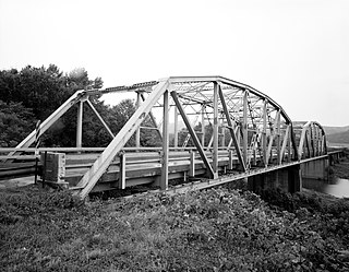
The St. Louis-San Francisco Overpass is a pony and deck truss bridge built in 1937 located in Imboden, Lawrence County, Arkansas. It carries U.S. Route 62 and Arkansas Highway 115 over the Spring River and the former St. Louis-San Francisco Railroad for 1,049.9 feet (320.0 m). The bridge has three Pratt deck trusses, each 112 feet (34 m) in length, and three Parker pony trusses, also 112 feet (34 m) long, with the balance of the bridge length in steel girder truss spans. The bridge is 24 feet (7.3 m) wide.

Twelve special routes of U.S. Route 63 currently exist. Arkansas and Missouri each contain five, with two in Iowa. There are also five former routings that have been removed from the system.

Several special routes of U.S. Route 49 exist. In order from south to north they are as follows.
The Illinois River Bridge, also known as the Midway Bridge, is a historic concrete arch bridge near Siloam Springs, Arkansas. It is located in Ozark National Forest, about 6 miles (9.7 km) east of Siloam Springs, at the end of Chambers Springs Road south of United States Route 412. The bridge has two elliptical arch spans, each spanning 68 feet (21 m), with a total structure length of 139 feet (42 m). Built in 1922 by the Luten Bridge Company of Knoxville, Tennessee, it is one of a modest number of bridges of this once-popular and common type remaining in the state.
The Vincennes Bridge Company, based in Vincennes, Indiana, was a designer and builder of bridges that was "one of Indiana's 'most successful bridge-building firms'".

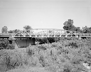
The North Fork Bridge carries Arkansas Highway 5 over the North Fork River, or the North Fork of the White River, in Norfork, Arkansas, United States. It is a modern steel girder bridge, replacing a 1937 Warren deck truss bridge, which was the first road crossing of the North Fork River in Norfork. The 1937 bridge, demolished in 2014, was listed on the U.S. National Register of Historic Places in 1990, but was delisted in 2015.

The St. Francis River Bridge, also known as the Lake City Bridge, was a historic bridge spanning the St. Francis River at Lake City, Arkansas. It was composed of 109 I-beam trestles and a single vertical lift span, and had a total length of 3,412 feet (1,040 m). The bridge was designed and built in 1934 by the Vincennes Bridge Company, and carried Arkansas Highway 18 until 1998, when a modern 4-span I-beam bridge was built adjacent to it. The old bridge was dismantled, leaving only the vertical lift segment on the east bank of the river.

The Black River Bridge carries U.S. Route 67 (US 67) across the Black River in Pocahontas, Arkansas. The bridge is a twin span, each carrying two lanes of traffic. The northern bridge was a historic structure, built in 1934 by the Pittsburgh-Des Moines Steel Co., and was listed on the National Register of Historic Places. In 2016 demolition began on the northern bridge, and it was delisted in 2018. This bridge consisted of two Parker trusses, one on either side of a Warren swing span, and trestled approaches, giving it a total length of 1,255 feet (383 m). It was one of three surviving swing bridges in the state. The southern bridge is a modern steel girder structure, built in 1986, whose construction rendered the swing section inoperative.

The Highway 79 Bridge was a historic bridge in Clarendon, Arkansas, United States. It was a tall two-span Warren truss bridge, formerly carrying two-lane U.S. Route 79 (US 79), a major arterial highway in the region, across the White River just west of the city's downtown. The steel truss had a total length of 720 feet (220 m), set on four concrete piers. The outer pairs of piers were 160 feet (49 m) apart, and the middle pair were 400 feet (120 m) apart. The approaches were concrete, set on concrete pilings, with the western approach continuing for some 3 miles (4.8 km) across secondary water bodies. The bridge was built in 1930-31 by the Austin Bridge Company.

The Newport Bridge is a historic cantilevered Warren truss bridge over the White River in Newport, Arkansas. Built in 1930 to carry U.S. Route 67 (US 67), the road it carries is now designated Arkansas Highway 367 (AR 367) after the former highway was relocated. The main bridge is 400 feet (120 m) long, with approaches from the west of 1,278 feet (390 m) and the south of 911 feet (278 m). It has cantilevered arms 138 feet (42 m) long supported by concrete piers, with a suspended Warren truss span of 125 feet (38 m). Designed by Ira G. Hedrick, it is one of three such bridges in the state.

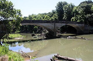
The South Fork Bridge is a historic bridge spanning the South Fork Saline River in Fountain Lake, Arkansas. It formerly carried Arkansas Highway 128, whose modern bridge now stands just to the south, a short way east of its junction with Arkansas Highway 5. It is a two-span concrete closed-spandrel arch structure, with spans of 57 feet (17 m) and a roadway width of 16 feet (4.9 m). It was built in 1928 by a county crew, after major flooding in 1927 damaged road infrastructure in the area.


