
Highway 22 is an east–west state highway in the Arkansas River Valley. The highway runs 75.60 miles (121.67 km) from US 64/US 71B east to Highway 7 in Dardanelle. The highway is one of the original 1926 state highways, and is maintained by the Arkansas State Highway and Transportation Department (AHTD).

State Road 2 is a former east–west state highway in the Arkansas Timberlands and Lower Arkansas Delta. The route was approximately 195 miles (314 km), and ran from US Route 67 (US 67) in Texarkana east to cross the Mississippi River near Lake Village, continuing as Mississippi Highway 10. On July 1, 1931, the route was entirely replaced by US Highway 82 (US 82) by the American Association of State Highway Officials (AASHTO). The route was maintained by the Arkansas Highway Department (AHD), now known as the Arkansas Department of Transportation (ArDOT).

U.S. Route 67 is a U.S. highway running from Presidio, Texas northeast to Sabula, Iowa. In the U.S. state of Arkansas, the route runs 279.15 miles (449.25 km) from the Texas border in Texarkana northeast to the Missouri border near Corning. The route passes through several cities and towns, including Hope, Benton, Little Rock, Jacksonville, Cabot, Beebe, Walnut Ridge, and Pocahontas.

U.S. Route 62 is a U.S. highway running from El Paso, Texas northeast to Niagara Falls, New York. In the U.S. state of Arkansas, the route runs 329.9 miles from the Oklahoma border near Summers east to the Missouri border in St. Francis, serving the northern portion of the state. The route passes through several cities and towns, including Fayetteville, Springdale, Bentonville, Harrison, Mountain Home, Pocahontas, and also Piggott. US 62 runs concurrent with several highways in Arkansas including Interstate 49 and U.S. Route 71 between Fayetteville and Bentonville, U.S. Route 412 through much of the state, U.S. Route 65 in the Harrison area, and with U.S. Route 63 and U.S. Route 67 in northeast Arkansas.
Frank Carmean was an architect in Arkansas. Not formally trained as an architect, but rather experienced in building construction, he became a designer. He joined a firm in 1927 that was developing the Edgemont residential area of Little Rock, and is believed to have designed all but one of the 16 homes in the development. The firm billed him as their "architect", and he toured to collect new designs. He introduced or expanded the use of Spanish Colonial architecture in Little Rock.

Old US 71 – Wilton Segment is a former alignment of U.S. Route 71 (US 71) near Wilton in Little River County, Arkansas. The roadway of about 2 miles (3.2 km) is a 1934 construction and was the main travel route in the county upon construction until US 59/US 71 bypassed this alignment in 1965.
Old US 71 – Greenland Segment is a former alignment of U.S. Route 71 (US 71) near Greenland in Washington County, Arkansas. The roadway of about 0.75 miles (1.21 km) is a 1930 construction and was the main travel route in the county upon construction until US 71 bypassed this alignment in 1980.
Justin Matthews (1876–1955) was an Arkansas road and bridge builder and real estate developer. He helped to design and expand many areas in central Arkansas.

The North Fork Bridge carries Arkansas Highway 5 over the North Fork River, or the North Fork of the White River, in Norfork, Arkansas, United States. It is a modern steel girder bridge, replacing a 1937 Warren deck truss bridge, which was the first road crossing of the North Fork River in Norfork. The 1937 bridge, demolished in 2014, was listed on the U.S. National Register of Historic Places in 1990.

The Arkansas Highway 57 Bridge is a Warren pony truss bridge in Stephens, Arkansas. It carries an old alignment of Arkansas Highway 57 over a branch of the Union Pacific Railroad near the city center. The bridge is now closed to traffic; the road on which it is located is now called Ruby Street. The bridge is distinctive in Arkansas for two reasons: first, it was the last bridge of its type on a state highway, and it has a pedestrian sidewalk on the outside of the trusses. It is unknown who built the trusses; the bridge was built in 1928.

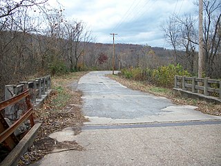
Old US 71-Little River Approach is a largely abandoned section of an old alignment of U.S. Route 71 (US 71) in southern Sevier County, Arkansas. Now designated Ashley Camp Road, it is a 2.75-mile-long (4.43 km) section of road, extending south from Arkansas Highway 234 to the Little River. It parallels the existing alignment of US 71, which travels to the west of this road section. The road is 18 feet (5.5 m) wide, with no shoulder, and was built in 1934 of Bates-style concrete, notable for its embedded reinforcing rods. The road was built on fill in order to raise it above the floodplain of the Little River, and includes five period bridges built as reliefs in the event of river flooding. It is the longest and most-intact section of the original US 71 alignment in the county.

Old US 71 – Ashdown Segment is a former alignment of U.S. Route 71 (US 71) in Ashdown, Arkansas. The roadway consists of about 0.5 miles (0.80 km) of North Park Avenue, extending from its intersection with the current of alignment of US 71 in the north, to East Main Street in the south. It is significant as a well-preserved example of concrete highway construction from the 1930s, built in a period when this was the preferred form of roadway surface. This segment of the highway was built using "Bates-style" pavement with reinforcing rods, and is 18 feet (5.5 m) wide.

Old US 71 – Ogden Segment is a former alignment of U.S. Route 71 (US 71) in Ogden, Arkansas. The roadway consists of about 0.5 miles (0.80 km) of Ogden Street and Grand Street, extending from an intersection with the current of alignment of US 71 in the north and a second junction with US 71 in the south. It is significant as a well-preserved example of concrete highway construction from the 1930s, built in a period when this was the preferred form of roadway surface. This segment of the highway was built using "Bates-style" pavement with reinforcing rods, and is 18 feet (5.5 m) wide.

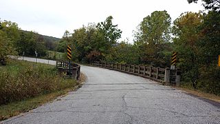
Highway A-7, Gilmore to Turrell is an old alignment of U.S. Route 63 (US 63) in Crittenden County, Arkansas. Built c. 1922, it travels parallel to the tracks of the Burlington Northern Santa Fe Railroad between Gilmore and Turrell, a distance of about 2.2 miles (3.5 km). Uniquely for practices of the time, this section of concrete roadway consists of a continuous pour, instead of the more typical practice of pouring the roadway in sections. The roadway is 17 feet (5.2 m) wide, with no shoulders, and carries two lanes of traffic. The road section includes a c. 1922 bridge, also made with reinforced concrete. US 63 was realigned off this segment in 1952, which is now known as Front Street in Gilmore and Eureka Street in Turrell.
The Highway B-1, Little Telico Creek Bridge is a historic bridge in Caldwell, Arkansas. It is a reinforced concrete bridge, built c. 1918, which now carries Airport Road over Little Telico Creek on the south side of the city. The bridge was built at a time when standards for concrete bridges had not yet been set. It has three spans with an overall length of 80 feet (24 m) and a width of 19 feet (5.8 m). It was built as part of a general construction plan to improve the road system in St. Francis County, and originally carried Highway B-1, which was later redesignated Arkansas Highway 1. It carried this roadway until 1964, when the present alignment of Highway 1 was built just to the east.

The Joseph E. England Jr. House is a historic house at 313 Skyline Drive in North Little Rock, Arkansas. It is a 1-1/2 story brick and stone structure, set on a wedge-shaped lot with expansive views of the Arkansas River. Built in 1928, it is a fine example of Tudor Revival architecture, and one of the Edgemont neighborhood's most elaborate pre-Depression houses. It was built for a prominent local banker and businessman who was an associated of Edgemont's developer, Justin Matthews.
The Cannon Creek Bridge is a historic bridge in rural western Madison County, Arkansas. The bridge is located southeast of Durham, carrying County Road 5340 across Cannon and Coon Creeks. It is a curving concrete deck structure with an overall length of about 103 feet (31 m) and a deck width of 20 feet (6.1 m). Built in 1929 to carry Arkansas Highway 16, it is the only known surviving curved concrete deck bridge in the state. It was bypassed by the present alignment of Highway 16 in the 1980s.
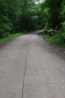
Old U.S. Route 64 is a historic former alignment of U.S. Route 64 (US 64) in Menifee, Arkansas. Now a portion of Canal Road, it consists of a 0.5-mile (0.80 km) section of concrete pavement, extending south from the current alignment of US 64 near the center of Menifee. Built in 1931, it is the longest intact portion of the highway's original alignment in Conway County. It was bypassed by the present alignment in 1961.
Highway 51 is a designation for two north–south state highways in Southwest Arkansas. One route of 53.37 miles (85.89 km) begins Highway 53 near Whelen Springs and runs north to US Highway 67 in Donaldson. A second route of 7.92 miles (12.75 km) runs parallel to US 270 northwest of Malvern. Both routes are maintained by the Arkansas Department of Transportation (ArDOT).

The Chilson Bridge, near Edgemont, South Dakota, is a bridge which brings a local road, formerly U.S. Highway 18, over BNSF railroad tracks. It was built in 1929 and was listed on the National Register of Historic Places in 1993. It has also been denoted as South Dakota Dept. of Transportation Bridge No. 24-162-102


