
Central Arkansas, also known as the Little Rock metro, designated by the United States Office of Management and Budget as the Little Rock-North Little Rock-Conway Metropolitan Statistical Area, is the most populous metro area in the U.S. state of Arkansas. With an estimated 2020 population of 748,031, it is the most populated area in Arkansas. Located at the convergence of Arkansas's other geographic regions, the region's central location make Central Arkansas an important population, economic, education, and political center in Arkansas and the South. Little Rock is the state's capital and largest city, and the city is also home to two Fortune 500 companies, Arkansas Children's Hospital, and University of Arkansas for Medical Sciences (UAMS).

Highway 5 is a designation for three state highways in Arkansas. The southern segment of 40.20 miles (64.70 km) runs from Highway 7 in Hot Springs north to Interstate 430 (I-430) and US Highway 70 (US 70) in Little Rock.

The Jenkins' Ferry Battleground State Park is the site of the American Civil War battle of Jenkins' Ferry, also known as the Engagement at Jenkins' Ferry, fought on Saturday, April 30, 1864, in present-day Grant County, Arkansas. The park was listed in the U.S. National Register of Historic Places on January 21, 1970, and, with seven other sites, is part of the Camden Expedition Sites National Historic Landmark, designated a National Historic Landmark District on April 19, 1994.

U.S. Route 67 is a U.S. highway running from Presidio, Texas northeast to Sabula, Iowa. In the U.S. state of Arkansas, the route runs 279.15 miles (449.25 km) from the Texas border in Texarkana northeast to the Missouri border near Corning. The route passes through several cities and towns, including Hope, Benton, Little Rock, Jacksonville, Cabot, Beebe, Walnut Ridge, and Pocahontas.

U.S. Route 62 is a U.S. highway running from El Paso, Texas northeast to Niagara Falls, New York. In the U.S. state of Arkansas, the route runs 329.9 miles from the Oklahoma border near Summers east to the Missouri border in St. Francis, serving the northern portion of the state. The route passes through several cities and towns, including Fayetteville, Springdale, Bentonville, Harrison, Mountain Home, Pocahontas, and also Piggott. US 62 runs concurrent with several highways in Arkansas including Interstate 49 and U.S. Route 71 between Fayetteville and Bentonville, U.S. Route 412 through much of the state, U.S. Route 65 in the Harrison area, and with U.S. Route 63 and U.S. Route 67 in northeast Arkansas.

The War Eagle Bridge is a historic bridge in War Eagle, Arkansas, United States, that is listed on the National Register of Historic Places.

The Red River Bridge was a truss bridge crossing the Red River at Garland, Arkansas. It carried vehicular traffic from 1931 to 1990 and has since been demolished.
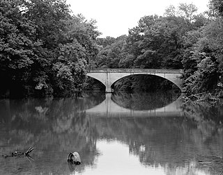
The Illinois River Bridge, also known as the Midway Bridge, is a historic concrete arch bridge near Siloam Springs, Arkansas. It is located in Ozark National Forest, about 6 miles (9.7 km) east of Siloam Springs, at the end of Chambers Springs Road south of United States Route 412. The bridge has two elliptical arch spans, each spanning 68 feet (21 m), with a total structure length of 139 feet (42 m). Built in 1922 by the Luten Bridge Company of Knoxville, Tennessee, it is one of a modest number of bridges of this once-popular and common type remaining in the state.

The Old Benton—Sardis Road Bridge is a historic bridge off Arkansas Highway 183 in Bauxite, Arkansas. It is a concrete deck truss bridge, with a span of about 15 feet (4.6 m), and is oriented east–west along an old road bed, resting on concrete abutments with diagonal wing walls. The bridge was built in 1919 as part of a project to build a new road connecting Benton to Sardis, which would facilitate the transport of bauxite mined in the area. Unlike other concrete bridges built at that time, this bridge included fieldstone in its guardrails, which provided a decorative aspect as well as perhaps being inexpensive locally. The method of contracting and construction of the road and bridge, involving the establishment of a road improvement district, was an important advance in the means by which roads were built in Arkansas.

The Hester-Lenz House is a historic house at 905 AR 5 N in Benton, Arkansas. Built in 1836 on what was then the Southwest Trail or the Military Road, it may be the oldest surviving house in Saline County that remains in its original location, and it may have been the location of a vote for independence of the state of Arkansas. The original construction, a two-story log dogtrot believed to have been built about 1836–37, was modified in the late 19th century by German immigrants with their distinctive vernacular styling.

The Little Missouri River Bridge, also known as the Nachitoch Bluff Bridge, is a historic bridge between rural southern Clark County, Arkansas and Nevada County, Arkansas. Now closed to traffic, it once carried County Road 179 over the Little Missouri River. Believed to be built in 1910, it is the only known Camelback Pratt truss bridge in the state. Its main span measures 185 feet (56 m), with a secondary Pratt truss span measuring 110 feet (34 m) in length, and there are I-beam-supported approaches on either side, giving the bridge a total length of 315 feet (96 m). The bridge is located on the historic route of the Natchitoches Trace, an early colonial French-Spanish trail through the area.

The Little Cossatot River Bridge is a historic bridge in rural Sevier County, Arkansas. It is located just west of Lockesburg, carrying County Road 139H over the Little Cossatot River. The bridge is a Warren pony truss structure, 70 feet (21 m) long, with 17-foot (5.2 m) approaches made of timber stringers. The trusses were built by the Morava Construction Company of Chicago, Illinois, and are believed to be the only of the company's trusses in the state. They feature a top chord that is a solid I-beam, which is connected by riveted plates to the bottom chord. The trusses are set on cylindrical concrete piers on either side of the river.

The Osage Creek Bridge is a historic bridge in southern Benton County, Arkansas. The bridge formerly carried County Road 71 across Osage Creek, about 4.5 miles (7.2 km) north of Tontitown, but it has been closed. It is a single-span iron Pratt through truss structure, with a span of 124 feet (38 m), resting on concrete abutments. It has a lattice guardrail on one side, a feature that rarely survives on bridges of this type. The bridge was built in 1911 by an unknown builder, and is one of about 60 Pratt truss bridges in the state.

The South Fork Bridge is a historic bridge spanning the South Fork Saline River in Fountain Lake, Arkansas. It formerly carried Arkansas Highway 128, whose modern bridge now stands just to the south, a short way east of its junction with Arkansas Highway 5. It is a two-span concrete closed-spandrel arch structure, with spans of 57 feet (17 m) and a roadway width of 16 feet (4.9 m). It was built in 1928 by a county crew, after major flooding in 1927 damaged road infrastructure in the area.

The Lake No. 1 Bridge is a historic bridge carrying Avondale Road across the northern tip of Lake Number 1 in North Little Rock, Arkansas. It is a closed-spandrel stone arch bridge with Rustic styling, built in the 1920s as part of the Lakewood development promoted by developer Justin Mathews. It has a single elliptical arch, spanning 18 feet (5.5 m), with a total structure length of 30 feet (9.1 m). It was one of eight stone arch bridges built in the state between 1923 and 1939, and one of the few that was privately built.

The Lincoln Avenue Viaduct, also known as the Cantrell Road Bridge, is a historic bridge, now carrying the westbound lanes of Cantrell Road across railroad tracks in downtown Little Rock, Arkansas. The bridge is a rainbow arch structure built out of reinforced concrete, with an arch length of 90 feet (27 m), and a total structure length of 144 feet (44 m). The bridge was built in 1928 by the Missouri-Pacific Railroad and given to the city; it is the only bridge of its type in the state.

The Judsonia Bridge is a historic bridge, carrying Van Buren Street across the Little Red River on the south side of Judsonia, Arkansas. It is a three-span metal truss swing bridge, with a total structure length of 397 feet (121 m). Its center span is 266 feet (81 m) long, and is mounted on a pivot on a central pier. It and the two approach trusses are all Warren trusses. Built in 1924, it is one of three known swing bridges in the state, and the only one with a cantilevered swinging truss. It was closed to traffic in 2007, and reopened in 2013 after restoration.

The Middle Fork of the Little Red River Bridge, also known as the Shirley Railroad Bridge, is a historic bridge in Shirley, Arkansas. It is a single-span iron Baltimore through truss, with a main span 153 feet (47 m) long, and steel beam approach spans giving it a total length of 339 feet (103 m). The main span rests on large concrete piers set in the river. The bridge was built in 1908 for the Missouri and North Arkansas Railroad, and carried the railroad until 1949. In 1978 the tracks were covered by a concrete deck, and the bridge was converted to single-lane vehicular road use, carrying County Road 125.

Highway 51 is a designation for two north–south state highways in Southwest Arkansas. One route of 53.37 miles (85.89 km) begins Highway 53 near Whelen Springs and runs north to US Highway 67 in Donaldson. A second route of 7.92 miles (12.75 km) runs parallel to US 270 northwest of Malvern. Both routes are maintained by the Arkansas Department of Transportation (ArDOT).

Highway 128 is a designation for four east–west state highways in Southwest Arkansas. One route of 11.99 miles (19.30 km) begins at Highway 7 in Sparkman and runs east to Highway 9 at Holly Springs. A second route of 6.23 miles (10.03 km) begins at Highway 51 at Joan and runs east to Highway 7/Highway 8 at Gravel Junction. A third route begins at Highway 7 near DeGray Lake Resort State Park and runs east and north to US Highway 270 Business (US 270B) in Hot Springs. A fourth route begins at Highway 5 in Fountain Lake and runs east to US 70. All routes are maintained by the Arkansas Department of Transportation (ArDOT).


