The Cotter Bridge, also known as the R. M. Ruthven Bridge and the White River Concrete Arch Bridge, carries U.S. Route 62 Business across the White River west of the city of Cotter in Baxter County, Arkansas. Upon completion, the bridge opened a part of the Ozarks previously inaccessible to motorists. Constructed in 1930, it is the only bridge built by the Marsh Engineering Company of Des Moines, Iowa, in the state of Arkansas.
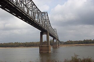
The Benjamin G. Humphreys Bridge was a two-lane cantilevered truss bridge carrying U.S. Route 82/U.S. Route 278 across the Mississippi River between Lake Village, Arkansas and Greenville, Mississippi. It was the first bridge to connect the two towns. The bridge was named for Benjamin G. Humphreys II, a former United States Congressman from Greenville.

The Bollman Truss Railroad Bridge across the Little Patuxent River at Savage, Maryland, is one of the oldest standing iron railroad bridges in the United States and the sole surviving example of a revolutionary design in the history of American bridge engineering. The 160-foot (48.8 m) double-span was built in 1852 at an unknown location on the main line of the Baltimore and Ohio Railroad. It was moved 35 years later to its present location, where it replaced the very first Bollman bridge. Today, it carries the Savage Mill Trail.

State Road 2 is a former east–west state highway in the Arkansas Timberlands and Lower Arkansas Delta. The route was approximately 195 miles (314 km), and ran from US Route 67 (US 67) in Texarkana east to cross the Mississippi River near Lake Village, continuing as Mississippi Highway 10. On July 1, 1931, the route was entirely replaced by US Highway 82 (US 82) by the American Association of State Highway Officials (AASHTO). The route was maintained by the Arkansas Highway Department (AHD), now known as the Arkansas Department of Transportation (ArDOT).

The Highway 78 Bridge at the Red River is an eight-span through truss bridge over the Red River between Oklahoma and Texas on Oklahoma State Highway 78/Texas State Highway 78. It was built as a federal relief project during the Great Depression as part of President Franklin Roosevelt's New Deal. Today the bridge and the area retain the look and feel of the time of its construction. As part of Highway 78 the bridge's average daily traffic was 1,700 cars per day.

The Kettle Falls Bridges is the collective name for a pair of steel cantilever bridges carrying State Route 20/U.S. Route 395 and the Kettle Falls International Railway across the Columbia River at Kettle Falls, Washington. The south bridge carries motor vehicle traffic while the similar northern span is used for rail.

The St. Francis River Bridge carries United States Route 70 over the St. Francis River near Madison in St. Francis County, Arkansas, United States. It consists of three Parker through trusses, each 162 feet (49 m) long, and a swing bridge span 230 feet (70 m) long. With approaches, the bridge has a total length of 921 feet (281 m). The swing span is mounted on a central pier, and is rotated by two workers operating a large hickory handle. The bridge was built in 1932–33, with the swing span design made to accommodate the demands of the United States War Department that the river remain navigable by military vessels. The bridge is one of three swing-span bridges in the state. It is likely that the swinging mechanism has never been used.
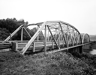
The Lee Creek Bridge in Natural Dam, Arkansas was a Pennsylvania through truss bridge that was built in 1934. It was a twin-span bridge with a total length of 587 feet (179 m), which carried Arkansas Highway 59 across Lee Creek. It rested on concrete piers and abutments, had a vertical clearance of 14 feet (4.3 m) and had a roadbed 22 feet (6.7 m) wide.

The St. Louis-San Francisco Overpass is a pony and deck truss bridge built in 1937 located in Imboden, Lawrence County, Arkansas. It carries U.S. Route 62 and Arkansas Highway 115 over the Spring River and the former St. Louis-San Francisco Railroad for 1,049.9 feet (320.0 m). The bridge has three Pratt deck trusses, each 112 feet (34 m) in length, and three Parker pony trusses, also 112 feet (34 m) long, with the balance of the bridge length in steel girder truss spans. The bridge is 24 feet (7.3 m) wide.

The Peats Ferry Bridge is a steel truss bridge that carries the Pacific Highway (B83) across the Hawkesbury River, between Kangaroo Point and Mooney Mooney Point, located 40 kilometres (25 mi) north of Sydney in New South Wales, Australia. The bridge carries the Hornsby to Kariong section of highway, while the adjacent Brooklyn Bridge carries the Pacific Motorway (M1).
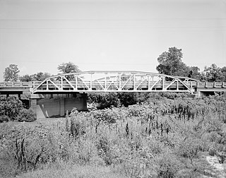
The Cache River Bridge is a Parker pony truss that spans the Cache River between Walnut Ridge and Paragould, Arkansas. It was built in 1934 by the Arkansas State Highway Commission and was designed by the Vincennes Bridge Company. Formerly carrying U.S. Route 412 and earlier Arkansas Highway 25, the structure was added to the National Register of Historic Places in 1990, and was bypassed by a new bridge in 1995.

The North Fork Bridge carries Arkansas Highway 5 over the North Fork River, or the North Fork of the White River, in Norfork, Arkansas, United States. It is a modern steel girder bridge, replacing a 1937 Warren deck truss bridge, which was the first road crossing of the North Fork River in Norfork. The 1937 bridge, demolished in 2014, was listed on the U.S. National Register of Historic Places in 1990, but was delisted in 2015.

The US 12–St. Joseph River Bridge is a three-span camelback bridge in Mottville, Michigan, that carried U.S. Route 12 across the St. Joseph River. Built in 1922, it is the fourth bridge to cross the river at this location. It has served as a pedestrian bridge since 1990 when a new bridge opened alongside to carry the highway. The bridge is the longest surviving camelback bridge in Michigan. It is a Michigan State Historic Site and is listed on the National Register of Historic Places.

The Black River Bridge carries U.S. Route 67 (US 67) across the Black River in Pocahontas, Arkansas. The bridge is a twin span, each carrying two lanes of traffic. The northern bridge was a historic structure, built in 1934 by the Pittsburgh-Des Moines Steel Co., and was listed on the National Register of Historic Places. In 2016 demolition began on the northern bridge, and it was delisted in 2018. This bridge consisted of two Parker trusses, one on either side of a Warren swing span, and trestled approaches, giving it a total length of 1,255 feet (383 m). It was one of three surviving swing bridges in the state. The southern bridge is a modern steel girder structure, built in 1986, whose construction rendered the swing section inoperative.

The Frog Bayou Bridge is a historic bridge in Crawford County, Arkansas, just south of Mountainburg. It is a single-span steel Parker through truss, which formerly carried Arkansas Highway 282 across Frog Bayou, a tributary of the Arkansas River. The bridge is now closed to traffic, and is located at the southern end of Silver Bridge Road. The bridge has a span of 150 feet (46 m) and a total structure length of 209 feet (64 m), and rests on abutments of stone and concrete. The northern approach to the bridge also includes a stone and concrete pier. The bridge was built in 1942.

The Highway 79 Bridge was a historic bridge in Clarendon, Arkansas. It was a tall two-span Warren truss bridge, formerly carrying two-lane U.S. Route 79 (US 79), a major arterial highway in the region, across the White River just west of the city's downtown. The steel truss had a total length of 720 feet (220 m), set on four concrete piers. The outer pairs of piers were 160 feet (49 m) apart, and the middle pair were 400 feet (120 m) apart. The approaches were concrete, set on concrete pilings, with the western approach continuing for some 3 miles (4.8 km) across secondary water bodies. The bridge was built in 1930-31 by the Austin Bridge Company.

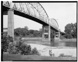
The Newport Bridge is a historic cantilevered Warren truss bridge over the White River in Newport, Arkansas. Built in 1930 to carry U.S. Route 67 (US 67), the road it carries is now designated Arkansas Highway 367 (AR 367) after the former highway was relocated. The main bridge is 400 feet (120 m) long, with approaches from the west of 1,278 feet (390 m) and the south of 911 feet (278 m). It has cantilevered arms 138 feet (42 m) long supported by concrete piers, with a suspended Warren truss span of 125 feet (38 m). Designed by Ira G. Hedrick, it is one of three such bridges in the state.

The Judsonia Bridge is a historic bridge, carrying Van Buren Street across the Little Red River on the south side of Judsonia, Arkansas. It is a three-span metal truss swing bridge, with a total structure length of 397 feet (121 m). Its center span is 266 feet (81 m) long, and is mounted on a pivot on a central pier. It and the two approach trusses are all Warren trusses. Built in 1924, it is one of three known swing bridges in the state, and the only one with a cantilevered swinging truss. It was closed to traffic in 2007, and reopened in 2013 after restoration.

The Ocean-to-Ocean Bridge is a through truss bridge spanning the Colorado River in Yuma, Arizona. Built in 1915, it was the first highway crossing of the lower Colorado and is the earliest example of a through truss bridge in Arizona. It is also the only example of a Pennsylvania truss within Arizona. Originally the bridge carried the transcontinental Ocean-to-Ocean Highway and later carried its successor, US 80 until a new bridge was built to the west in 1956. Between 1988 and 2001, the bridge was closed to vehicular traffic and only traversable by pedestrians and bicyclists. After a major restoration, the bridge was rehabilitated and reopened to vehicular traffic in 2002, with a re-dedication by the Quechan nation and Yuma Crossing National Heritage Area. The bridge became part of Historic US 80 in 2018.

Manzanola Bridge was a truss bridge which was originally built in 1911 by the Patterson-Burghardt Bridge Company over the Colorado River and later moved over the Arkansas River in the year 1950. The bridge used to connect the town of Manzanola, Otero County, with Crowley County in Colorado.