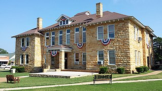
Stone County is located in the Ozark Mountains in the U.S. state of Arkansas. The county is named for rugged, rocky area terrain of the Ozarks. Created as Arkansas's 74th county on April 21, 1873, Stone County has two incorporated cities: Mountain View, the county seat and most populous city, and Fifty-Six. The county is also the site of numerous unincorporated communities and ghost towns.

Randolph County is located between the Ozark Mountains and Arkansas Delta in the U.S. state of Arkansas. The county is named for John Randolph, a U.S. senator from Virginia influential in obtaining congressional approval of the Louisiana Purchase, which includes today's Randolph County. Created as Arkansas's 32nd county on October 29, 1835, Randolph County has two incorporated cities, including Pocahontas, the county seat and most populous city. The county is also the site of numerous unincorporated communities and ghost towns.

Prairie County is located in the Central Arkansas region of the U.S. state of Arkansas. The county is named for the Grand Prairie, a subregion of the Arkansas Delta known for rice cultivation and aquaculture which runs through the county. Created as Arkansas's 54th county in 1846, Prairie County is home to four incorporated towns, including DeValls Bluff, the southern district county seat, and two incorporated cities, including Des Arc, the northern district county seat. The county is also the site of numerous unincorporated communities and ghost towns. Occupying 676 square miles (175,000 ha), Prairie County is the median-sized county in Arkansas. As of the 2010 Census, the county's population is 8,715 people in 4,503 households. Based on population, the county is the ninth-smallest county of the 75 in Arkansas.
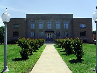
Lincoln County is located between the Arkansas Timberlands and Arkansas Delta in the U.S. state of Arkansas. It is also within the Pine Bluff metro area, and on the outer edge of the Central Arkansas region. The county is named for Abraham Lincoln, the 16th President of the United States. Created as Arkansas's 65th county on March 28, 1871, Lincoln County has three incorporated cities, including Star City, the county seat and most populous city. The county contains 46 unincorporated communities and ghost towns, Cane Creek State Park at the confluence of Cane Creek and Bayou Bartholomew, and nine listings on the National Register of Historic Places to preserve the history and culture of the county.

Highway 87 is a designation for four north–south state highways in Arkansas. Created during the 1926 Arkansas state highway numbering, the original alignment remains between Bradford and Pleasant Plains, though it has been revised and extended over the years. The three remaining segments are former county roads, connecting rural communities to local points of interest and other state highways. All three were added to the state highway system in 1973 during a period of system expansion. All segments are maintained by the Arkansas Department of Transportation (ArDOT).

Highway 88 is a designation for five state highways in Arkansas. All routes are maintained by the Arkansas Department of Transportation (ArDOT).
Highway 263 is a north–south state highway in the Arkansas Ozark Mountains. A low-volume, two-lane road, Highway 263 connects several rural unincorporated communities to the state highway system. The highway was first established on July 10, 1957 in Stone County and extended by the Arkansas State Highway Commission in 1963 and 1965. A second segment was created in Cleburne County in 1963, and the gap was closed between the two segments in 1994. The route is maintained by the Arkansas Department of Transportation (ARDOT).

Strickler is an unincorporated community in Cove Creek Township, Washington County, Arkansas, United States. It is located on Arkansas Highway 265, northwest of Devil's Den State Park.
Bayou Meto is an unincorporated community in Arkansas County, Arkansas, United States. The community is located where Arkansas Highway 276S diverges from Arkansas Highway 276.
Casscoe is an unincorporated community in Arkansas County, Arkansas, United States. The community is located where Arkansas Highway 33 Spur diverges from Arkansas Highway 33.
Pleasant Valley is an unincorporated community in Carroll County, Arkansas, United States. The community is located on Arkansas Highway 143.
Furlow is an unincorporated community in Lonoke County, Arkansas, United States. The community is located west of Lonoke and is surrounded by fish farms.

The Arkansas Highway System is made up of all the highways designated as Interstates, U.S. Highways and State Highways in the US state of Arkansas. The system is maintained by the Arkansas Department of Transportation (ArDOT), known as the Arkansas State Highway Department (AHD) until 1977 and the Arkansas State Highway and Transportation Department (AHTD) from 1977 to 2017. The system contains 16,442.90 miles (26,462.28 km) of Interstates, U.S. Routes, state highways, and special routes. The shortest members are unsigned state highways Arkansas Highway 806 and Arkansas Highway 885, both 0.09 miles (0.14 km) in length. The longest route is U.S. Route 67, which runs 296.95 miles (477.89 km) from Texarkana to Missouri.
White Rock is an unincorporated community in Fayetteville Township, Washington County, Arkansas, United States. It is located about three miles west of Fayetteville on Arkansas Highway 16. Goose Creek is just south of the community.
Arkmo is an unincorporated community located in both Mississippi County, Arkansas and Dunklin County, Missouri United States. Arkmo is situated at the junction of Arkansas Highway 77 and Missouri Route 108, 3.5 miles (5.6 km) south of Arbyrd; the community primarily lies on the Missouri side of the border.

Highway 39 is a designation for two state highways in southeast Arkansas. The western segment of 9.98 miles (16.06 km) runs from US Route 49 (US 49) at Blackton to US 49/Highway 241. Another segment of 8.89 miles (14.31 km) runs north from Highway 1 and Highway 316 near Turner to US 49 in rural Phillips County.

The Little Cypress Creek Brook is a historic bridge in rural western Phillips County, Arkansas. Located south of the hamlet of Postelle, it carries County Road 600 over Little Cypress Creek, west of Arkansas Highway 39. It consists of two 15-foot (4.6 m) spans of an aluminum-beam substructure, resting on concrete abutments and piers, with textured metal deck plating as the road surface. The bridge was built in 1942, and was probably designed by the engineering staff of the Arkansas State Highway Commission. It is a well-preserved example of a World War II-era bridge.
Hamlet is an unincorporated community in Faulkner County, Arkansas, United States. The community is located at the junction of U.S. Route 64 and Arkansas Highway 36, about halfway between Conway and Vilonia along the former.
Farewell is a community in Carroll County in northwest Arkansas, United States. The community is on Arkansas Highway 311, northeast of Green Forest. The community of Denver lies on the banks of Long Creek approximately three miles to the east. The community of Yocum is three miles northwest on Arkansas Highway 103.


