
Prairie Creek is a census-designated place (CDP) in Benton County, Arkansas, United States. Per the 2020 census, the population was 2,217. It is a lakefront community adjacent to Beaver Lake and Rogers within the Northwest Arkansas region.

Kirby is an unincorporated census-designated place in northern Pike County, Arkansas, United States. The community lies on U.S. Route 70; it is located halfway between Daisy and Glenwood. Per the 2020 census, the population was 721.
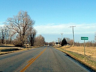
Maysville is an unincorporated community and census-designated place (CDP) in Benton County, Arkansas, United States. It is the westernmost settlement in the state of Arkansas. Per the 2020 census, the population was 117. It is located in the Northwest Arkansas region.

Oark is an unincorporated community and census-designated place (CDP) in Johnson County, Arkansas, United States. Oark is located on Arkansas Highway 215, 16 miles (26 km) northwest of Clarksville. It was first listed as a CDP in the 2020 census with a population of 43.
Oak Grove is an unincorporated community and census-designated place (CDP) in Moreland Township, Pope County, Arkansas, United States. It was first listed as a CDP in the 2020 census with a population of 177.

Kingston is an unincorporated community and census-designated place (CDP) in northeast Madison County, Arkansas, United States. It was first listed as a CDP in the 2020 census with a population of 97.
Drasco is an unincorporated community and census-designated place (CDP) in Cleburne County, Arkansas, United States, with a ZIP code of 72530. Drasco lies just northeast of Greers Ferry Lake and includes the lakeside community of Tannenbaum.
Vanndale is an unincorporated community and census-designated place (CDP) in Searcy Township, Cross County, Arkansas, United States. It was first listed as a CDP in the 2020 census with a population of 339. Vanndale was the county seat of Cross County from 1886 until 1903, when it was moved to the booming railroad town of Wynne. The community was named for John W. Vann, postmaster. Vanndale was formerly on Highway 1, but has now been bypassed and is on Highway 1B.

Lost Bridge Village is a residential subdivision near the town of Garfield in Benton County, Arkansas, United States. Per the 2020 census, the population was 397. It is located in the Northwest Arkansas region.

Tumbling Shoals is a census-designated place in Cleburne County, Arkansas, United States. Per the 2020 census, the population was 902.
Deer is an unincorporated community and census-designated place (CDP) in Newton County, Arkansas, United States. Deer is located on Arkansas Highway 16, 12.5 miles (20.1 km) south of Jasper. Deer has a post office with ZIP code 72628.
Mount Judea is an unincorporated community and census-designated place (CDP) in Newton County, Arkansas, United States. Mount Judea is located at the junction of Arkansas highways 74 and 123, 9.5 miles (15.3 km) southeast of Jasper. Mount Judea has a post office with ZIP code 72655.
Witts Springs is an unincorporated community and census-designated place (CDP) in Searcy County, Arkansas, United States. It was first listed as a CDP in the 2020 census with a population of 33. Witts Springs is located on Arkansas Highway 16, 16.5 miles (26.6 km) southwest of Marshall. Witts Springs has a post office with ZIP code 72686. John Campbell who served in Mexico and the Confederate Army and who was a county surveyor and judge as well as a state senator for two terms had his post office at Witts Springs.
Oneida is an unincorporated community and census-designated place (CDP) in Phillips County, Arkansas, United States. Oneida is located along Arkansas Highway 85, 3.5 miles (5.6 km) north-northeast of Lake View. Oneida has a post office with ZIP code 72369. It was first listed as a CDP in the 2020 census with a population of 13.
Floral is an unincorporated community and census-designated place (CDP) in Independence County, Arkansas, United States. It was first listed as a CDP in the 2020 census with a population of 109. Floral is located on Arkansas Highway 87, 8 miles (13 km) west-northwest of Pleasant Plains. Floral has a post office with ZIP code 72534.
Pleasant Grove is an unincorporated community and census-designated place (CDP) in Stone County, Arkansas, United States. It was first listed as a CDP in the 2020 census with a population of 235. Pleasant Grove is located along Arkansas Highway 14, 12.5 miles (20.1 km) east-southeast of Mountain View. Pleasant Grove has a post office with ZIP code 72567.
Gregory is an unincorporated community and census-designated place (CDP) in Woodruff County, Arkansas, United States. It was first listed as a CDP in the 2020 census with a population of 43. Gregory is located along Arkansas Highway 33, 9 miles (14 km) south of Augusta. Gregory has a post office with ZIP code 72059.
Jerusalem is an unincorporated community and census-designated place (CDP) in Conway County, Arkansas, United States. It was first listed as a CDP in the 2020 census with a population of 137. Jerusalem is located on Arkansas Highway 124, 18 miles (29 km) north-northwest of Morrilton. Jerusalem has a post office with ZIP code 72080.
Edgemont is an unincorporated community and census-designated place (CDP) in Cleburne County, Arkansas, United States. Edgemont is located on the north side of Greers Ferry Lake along Arkansas Highway 16, 2 miles (3.2 km) northwest of Greers Ferry. Edgemont has a post office with ZIP code 72044.
Collins is an unincorporated community and census-designated place (CDP) in Drew County, Arkansas, United States. It is located along Arkansas Highway 35, 7 miles (11 km) west of Dermott and 15 miles (24 km) southeast of Monticello. It was first listed as a CDP in the 2020 census with a population of 149.


