
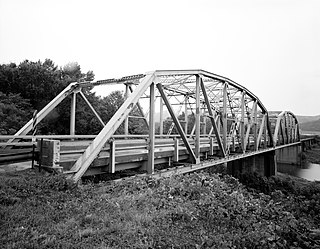
The Mulberry River Bridge, also known as the Silver Bridge and the Wire Ford Bridge, is a historic Pratt through truss bridge northeast of Pleasant Hill, Arkansas, now a neighborhood of the city of Mulberry. The bridge normally carries Wire Road/Center Point Road across the Mulberry River. The bridge has three spans, set on metal caissons filled with concrete, and has a total length of 342 feet (104 m). Each span measures 105 feet (32 m), and has a deck width of 12 feet (3.7 m) and a vertical clearance of 13 feet (4.0 m). In 1927 it was rebuilt when two of the three spans were washed out by the Mulberry River. The bridge is the last known multi-span Pratt through truss bridge in the state.

The Cove Creek Bridge is a historic bridge, carrying Arkansas Highway 309 across Cove Creek, south of the hamlet of Corley, Arkansas in the Ozark-St. Francis National Forest. It is a two-span closed-spandrel masonry arch structure, with each span measuring 13 feet (4.0 m) and an overall structure length of 26 feet (7.9 m). It is built entirely out of stone, with a concrete and asphalt deck, and concrete barriers at the sides. It was built in 1936 with funding support from the Works Progress Administration.
The Lee Creek Bridge in Natural Dam, Arkansas was a Pennsylvania through truss bridge that was built in 1934. It was a twin-span bridge with a total length of 587 feet (179 m), which carried Arkansas Highway 59 across Lee Creek. It rested on concrete piers and abutments, had a vertical clearance of 14 feet (4.3 m) and had a roadbed 22 feet (6.7 m) wide.

The War Eagle Bridge is a historic bridge in War Eagle, Arkansas, United States, that is listed on the National Register of Historic Places.
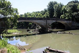
The Illinois River Bridge, also known as the Midway Bridge, is a historic concrete arch bridge near Siloam Springs, Arkansas. It is located in Ozark National Forest, about 6 miles (9.7 km) east of Siloam Springs, at the end of Chambers Springs Road south of United States Route 412. The bridge has two elliptical arch spans, each spanning 68 feet (21 m), with a total structure length of 139 feet (42 m). Built in 1922 by the Luten Bridge Company of Knoxville, Tennessee, it is one of a modest number of bridges of this once-popular and common type remaining in the state.

The Sanitarium Lake Bridges Historic District encompasses a pair of stone arch bridges on Carroll County Road 317 in southern Eureka Springs, Arkansas.

The Goff Farm Stone Bridge is a historic bridge in eastern Fayetteville, Arkansas. It carries Goff Farm Road across an unnamed creek just north of Stonebridge Meadows Golf Club. The bridge is a single-span stone arch with a span of 20 feet (6.1 m) and a total bridge length of 150 feet (46 m). The bridge's builder is unknown, and its design suggests it was built circa 1860, when the road it carries was a major east–west thoroughfare connecting Fayetteville and Huntsville. It is believed to be the oldest masonry bridge in the state, and is one of the state's small number of surviving 19th-century stone bridges.

The Milltown Bridge is a historic stone arch bridge in rural southeastern Sebastian County, Arkansas. The bridge carries County Road 77 across an unnamed brook just west of its junction with White Mountain Road. It is a two-span closed spandrel structure, with each arch spanning 10 feet (3.0 m) and a total length of 24 feet (7.3 m). The arches are formed out of rough-cut stone voussoirs. It was built in the 1930s with funding from the Works Progress Administration, and was, when listed on the National Register of Historic Places in 1990, one of only eight documented bridges of its type in the state. The bridge was delisted from the register in 2002.

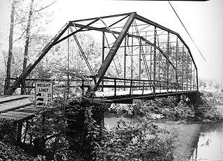
The Mountain Fork Bridge is a historic bridge in rural Polk County, Arkansas. It carries County Road 38 across Mountain Fork River north of Hatfield and southwest of Mena. The bridge consists of two spans of steel Pratt pony trusses, with a total length of 406 feet (124 m), including approach spans. The trusses are set on piers consisting of steel rings filled with concrete; each of these spans is 80 feet (24 m) long. The bridge's construction date and builder are unknown; it predates the standardization of bridge designs in the state in 1923. It is estimated to date to the early 1900s.

The Newport Bridge is a historic cantilevered Warren truss bridge over the White River in Newport, Arkansas. Built in 1930 to carry U.S. Route 67 (US 67), the road it carries is now designated Arkansas Highway 367 (AR 367) after the former highway was relocated. The main bridge is 400 feet (120 m) long, with approaches from the west of 1,278 feet (390 m) and the south of 911 feet (278 m). It has cantilevered arms 138 feet (42 m) long supported by concrete piers, with a suspended Warren truss span of 125 feet (38 m). Designed by Ira G. Hedrick, it is one of three such bridges in the state.

The Miller Creek Bridge is a historic bridge, carrying Miller Creek Road across Miller Creek, just north of the city limits of Batesville, Arkansas. Built in 1914, it is the state's oldest surviving concrete bridge. It is a two-span arched structure with a total length of 123 feet (37 m), and a width of 12 feet (3.7 m), carrying a single lane of traffic. The bridge is somewhat overengineered, as the use of concrete in bridge construction was then relatively new, and knowledge of the material's properties in this application was not well understood.

The Little Buffalo River Bridge is a historic bridge in central Newton County, Arkansas. The bridge carries Arkansas Highway 327 across the Little Buffalo River between Parthenon and Jasper. It is a seven-span reinforced concrete T-beam structure, with a total length of 212 feet (65 m) and a longest single span of 30 feet (9.1 m). It has a curb width of 19.1 feet (5.8 m), and an overall width of 22.3 feet (6.8 m), including the concrete balustrades on each side. It was built in 1939.

The South Fork Bridge is a historic bridge spanning the South Fork Saline River in Fountain Lake, Arkansas. It formerly carried Arkansas Highway 128, whose modern bridge now stands just to the south, a short way east of its junction with Arkansas Highway 5. It is a two-span concrete closed-spandrel arch structure, with spans of 57 feet (17 m) and a roadway width of 16 feet (4.9 m). It was built in 1928 by a county crew, after major flooding in 1927 damaged road infrastructure in the area.

The West James Street Overpass is a historic bridge in Redfield, Arkansas. It carries West James Street across the Union Pacific railroad tracks near the center of the community.
The Wallace Bridge, also known as the Nimrod Bridge, is a historic bridge in rural Perry County, Arkansas. It is located southeast of the hamlet of Nimrod, carrying County Road 18 across the Fourche La Fave River. It is a single-span camelback through truss structure, set on concrete abutments. The bridge has a truss length of 180 feet (55 m) and a roadway width of 15 feet (4.6 m). The bridge was built in 1908, its trusses constructed by the Southwestern Bridge Company. At the time of its listing on the National Register of Historic Places in 2008, it was one of three surviving camelback truss bridges in the state.

The Middle Fork of the Little Red River Bridge, also known as the Shirley Railroad Bridge, is a historic bridge in Shirley, Arkansas. It is a single-span iron Baltimore through truss, with a main span 153 feet (47 m) long, and steel beam approach spans giving it a total length of 339 feet (103 m). The main span rests on large concrete piers set in the river. The bridge was built in 1908 for the Missouri and North Arkansas Railroad, and carried the railroad until 1949. In 1978 the tracks were covered by a concrete deck, and the bridge was converted to single-lane vehicular road use, carrying County Road 125.
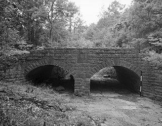
The Spring Lake Bridge is a historic bridge in the eastern part of Ozark-St. Francis National Forest, carrying County Road 35 across an inlet of Spring Lake known as Bob Barnes Branch, in the Spring Lake Recreation Area with the Ozark–St. Francis National Forest. It is a two-span closed-spandrel stone arch bridge with a total length of 36 feet (11 m). Each arch is 10 feet (3.0 m) long and 6 feet (1.8 m) high. Built in 1936 with federal funding, it is one of the state's finest examples of a stone arch bridge.

The Ward's Crossing Bridge is a historic bridge in rural eastern Yell County, Arkansas. The bridge carries County Road 8 across the Fourche La Fave River, south of Plainview. It is a single-span camelback through truss, whose main span measures 160 feet (49 m), with a total structure length, including approaches of 240 feet (73 m). The bridge is mounted on concrete piers, and has a wooden deck carrying a single lane of traffic. The bridge was built in 1905 by the Converse Bridge Company. It is the only camelback truss bridge in the county, and one of only three known in the state.
The Petit Jean River Bridge is a historic bridge in rural southern Logan County, Arkansas. The bridge carries Old Highway 109 across the Petit Jean River between Sugar Grove and Magazine. It consists of a single-span steel Pratt through truss and two masonry approach spans, set on concrete piers in the river. The total structure length is 273 feet (83 m), with a roadway width of 19 feet (5.8 m) and a total width of 24 feet (7.3 m). The bridge was built in 1938.

The Cove Creek Tributary Bridge is a historic bridge in rural Logan County, Arkansas. It is a two-span closed-spandrel stone arch bridge, carrying Arkansas Highway 309 across a tributary of Cove Creek north of Corley in Ozark-St. Francis National Forest. Each of its arches is 11 feet (3.4 m) long, and the structure is an overall 23 feet (7.0 m) in length. Concrete barriers form the sides of the bridge on either side of the roadway. The bridge was built in 1936 under the auspices of the Arkansas Highway Commission.


