Corley is an unincorporated community in Logan County, Arkansas, United States. It is the location of Burnett Springs, which is located at the end of County Road 704, Cove Creek Bridge, on AR 309 over Cove Creek, Cove Creek Tributary Bridge, on AR 309 over a tributary of Cove Creek, Cove Lake Bathhouse, located on Forest Service Rd. 1608A in the Ozark-St. Francis National Forest and Cove Lake Spillway Dam-Bridge located on AR 309 in the Ozark-St. Francis National Forest. All five of these places are listed on the National Register of Historic Places.

The Davies Bridge carries Red Bluff Drive across Cedar Creek, just north of Arkansas Highway 154 in Petit Jean State Park, Arkansas. It is a single-span closed-spandrel masonry arch structure, with an arch 20 feet (6.1 m) long and 10 feet (3.0 m) high. It is built out of mortared ashlar fieldstone laid in courses, with some stones left rusticated and protruding from the sides. The bridge was built in 1934 by a crew of the Civilian Conservation Corps that was developing the park's facilities.

The Cove Creek Bridge is a historic bridge, carrying Arkansas Highway 309 across Cove Creek, south of the hamlet of Corley, Arkansas in the Ozark-St. Francis National Forest. It is a two-span closed-spandrel masonry arch structure, with each span measuring 13 feet (4.0 m) and an overall structure length of 26 feet (7.9 m). It is built entirely out of stone, with a concrete and asphalt deck, and concrete barriers at the sides. It was built in 1936 with funding support from the Works Progress Administration.

Arkansas Highway 309 is a designation for two state highways in Western Arkansas. One route of 5.11 miles (8.22 km) runs from Yell County Route 28 (CR 28) at Blue Mountain Lake northeast to Highway 10 at Waveland. A second segment begins at Highway 10 in Havana and winds northwest through the Ozark National Forest to Highway 23 at Webb City via Paris. A portion of the second route is designated as the Mount Magazine Scenic Byway, one of eleven Arkansas Scenic Byways maintained by the Arkansas State Highway and Transportation Department (AHTD).
The Lee Creek Bridge in Natural Dam, Arkansas is a Pennsylvania through truss bridge that was built in 1934. It is a twin-span bridge with a total length of 587 feet (179 m), which carries Arkansas Highway 59 across Lee Creek. It rests on concrete piers and abutments, has a vertical clearance of 14 feet (4.3 m) and has a roadbed 22 feet (6.7 m) wide.

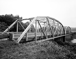
The War Eagle Bridge is a historic bridge in War Eagle, Arkansas, United States, that is listed on the National Register of Historic Places.

The North Fork Bridge carries Arkansas Highway 5 over the North Fork River, or the North Fork of the White River, in Norfork, Arkansas, United States. It is a modern steel girder bridge, replacing a 1937 Warren deck truss bridge, which was the first road crossing of the North Fork River in Norfork. The 1937 bridge, demolished in 2014, was listed on the U.S. National Register of Historic Places in 1990, but was delisted in 2015.

The Beaver Bridge in Beaver, Arkansas, is a historic one-lane suspension bridge carrying Arkansas Highway 187 over the White River at Table Rock Lake. Built in 1949 by the Pioneer Construction Company, the structure is the only suspension bridge open to traffic in Arkansas. The Beaver Bridge was added to the National Register of Historic Places in 1990.
The Mulladay Hollow Bridge is a stone arch bridge in rural Carroll County, Arkansas. It carries County Road 204 across Mulladay Hollow Creek, near the southwestern tip of Lake Leatherwood It has two spans, and is built out of roughly square and semi-coursed fieldstone. The arches are elliptical in shape, 9 feet (2.7 m) in height and 9.5 feet (2.9 m) wide, with nearly-square voussoirs forming the arches. The barrels of the arches are skewed with respect to the spandrels, and the wing walls are slightly curved. The roadway carried by the bridge is 30 feet (9.1 m) wide, and the total length of the structure is 120 feet (37 m). The bridge was built with Works Progress Administration funding as part of the development of Lake Leatherwood as a recreation area.

The Frog Bayou Bridge is a historic bridge in Crawford County, Arkansas, just south of Mountainburg. It is a single-span steel Parker through truss, which formerly carried Arkansas Highway 282 across Frog Bayou, a tributary of the Arkansas River. The bridge is now closed to traffic, and is located at the southern end of Silver Bridge Road. The bridge has a span of 150 feet (46 m) and a total structure length of 209 feet (64 m), and rests on abutments of stone and concrete. The northern approach to the bridge also includes a stone and concrete pier. The bridge was built in 1942.
The Cedar Creek Bridge is a historic bridge in rural southern Independence County, Arkansas. It is located on Goodie Creek Road, about 1.5 miles (2.4 km) south of its junction with Arkansas Highway 14. It is a two-span stone masonry structure, spanning Cedar Creek, a tributary to the White River, with two closed-spandrel arches having a total length of 30 feet (9.1 m). Its deck is 24.1 feet (7.3 m) wide, with a total structure width of 26.1 feet (8.0 m), including the parapets at the sides. The bridge was built 1941, and was probably designed by an engineer of the state's highway department.

The Harp Creek Bridge is a historic bridge in rural northern Newton County, Arkansas, carrying Arkansas Highway 7 across Harp Creek in the hamlet of Harrison. It is an open-spandrel arch bridge, built out of reinforced concrete in 1928 by the Luten Bridge Company. The arches span 69 feet (21 m), and are mounted on piers set 24 feet (7.3 m) from the abutments. The total structure length is 117 feet (36 m), and the deck is 23 feet (7.0 m) wide. Concrete balustrades line the sides of the bridge.

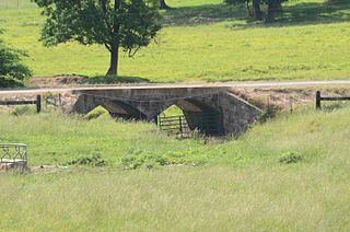
The Lake Catherine State Park-Bridge No. 2 is a historic bridge, carrying Arkansas Highway 171 across an unnamed stream in the western part of Lake Catherine State Park in Hot Spring County, Arkansas. The bridge is a rustic stone structure, with stone abutments rising to low piers just above the roadway at its four corners. Built in 1935 by crews of the Civilian Conservation Corps, it is one of a number of surviving CCC-built structures in the park.

The South Fork Bridge is a historic bridge spanning the South Fork Ouachita River in Fountain Lake, Arkansas. It formerly carried Arkansas Highway 128, whose modern bridge now stands just to the south, a short way east of its junction with Arkansas Highway 5. It is a two-span concrete closed-spandrel arch structure, with spans of 57 feet (17 m) and a roadway width of 16 feet (4.9 m). It was built in 1928 by a county crew, after major flooding in 1927 damaged road infrastructure in the area.
The Springfield Bridge is a historic bowstring truss bridge, located in Beaverfork Lake Park in Conway, Arkansas, USA. It originally spanned Cadron Creek in rural Faulkner County east of Springfield. It is 188 feet (57 m) long, set on stone abutments, with tubular metal top chords that rise 15 feet (4.6 m) above the bottom chords. Built circa 1871–74, it is the oldest documented highway bridge in the state and its only documented bowstring arch bridge.
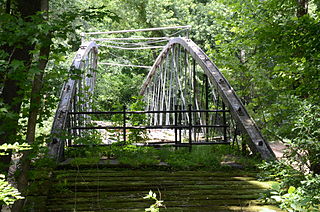
The Cove Creek Bridge was a historic bridge in rural eastern Conway County, Arkansas. It carried Arkansas Highway 124 across Cove Creek, just west of the hamlet of Martinsville, and west of the city of Twin Groves. It was a three-span steel structure with a total length of 267 feet (81 m). The main span was a Pratt through truss 101 feet (31 m), mounted on concrete piers, while the approach spans on either end were smaller pony trusses each 83 feet (25 m) long. The bridge was built in 1957, and was the one of few Pratt truss bridges in the state.

The Big Piney Creek Bridge is a historic bridge, carrying Arkansas Highway 123 across Big Piney Creek in Ozark-St. Francis National Forest, northeast of Hagarville, Arkansas. Its main span is a Warren through truss structure, 141 feet (43 m) in length, with steel deck girder approach spans giving the bridge a total length of 461 feet (141 m). The trusses are mounted on concrete piers. The bridge was built in 1931, during a period of financial hardship, and was for economic reasons built with a single-lane 12-foot (3.7 m) roadway.
The Petit Jean River Bridge is a historic bridge in rural southern Logan County, Arkansas. The bridge carries Old Highway 109 across the Petit Jean River between Sugar Grove and Magazine. It consists of a single-span steel Pratt through truss and two masonry approach spans, set on concrete piers in the river. The total structure length is 273 feet (83 m), with a roadway width of 19 feet (5.8 m) and a total width of 24 feet (7.3 m). The bridge was built in 1938.

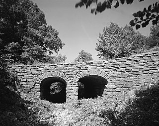
The Cove Creek Tributary Bridge is a historic bridge in rural Logan County, Arkansas. It is a two-span closed-spandrel stone arch bridge, carrying Arkansas Highway 309 across a tributary of Cove Creek north of Corley in Ozark-St. Francis National Forest. Each of its arches is 11 feet (3.4 m) long, and the structure is an overall 23 feet (7.0 m) in length. Concrete barriers form the sides of the bridge on either side of the roadway. The bridge was built in 1936 under the auspices of the Arkansas Highway Commission.

The Cove Lake Bathhouse is a historic recreational facility at the Cove Lake Recreation Area, north of Corley, Arkansas in the Ozark-St. Francis National Forest. It is a T-shaped stone structure, built of fieldstone with a gabled roof. A porch extends across the front, supported by stone piers. The roof is pierced by three triangular dormers with vents in them. It was built in 1937 with funding from the Works Progress Administration, and represents a distinctive departure from the more typical Rustic architecture produced by WPA projects.


