
Ashley County is a rural South Arkansas county with a culture, economy, and history based on timber and agriculture. Created as Arkansas's 52nd county on November 30, 1848, Ashley County has seven incorporated municipalities, including Hamburg, the county seat and Crossett, the most populous city. The county is also the site of numerous unincorporated communities and ghost towns. The county is named for Chester Ashley, a prominent lawyer in the Arkansas Territory and U.S. senator from the state from 1844 to 1848.

Highway 87 is a designation for four north–south state highways in Arkansas. Created during the 1926 Arkansas state highway numbering, the original alignment remains between Bradford and Pleasant Plains, though it has been revised and extended over the years. The three remaining segments are former county roads, connecting rural communities to local points of interest and other state highways. All three were added to the state highway system in 1973 during a period of system expansion. All segments are maintained by the Arkansas Department of Transportation (ArDOT).

Highway 215 is a designation for three north–south state highways in northwest Arkansas. A southern route of 8.80 miles (14.16 km) runs north from Franklin County Road 31 and Franklin County Road 221 (CR 31/CR 221) at Dahoma to Highway 96 near the Arkansas River. A second route of 15.94 miles (25.65 km) begins at US Route 64/Highway 917 (US 64/AR 917) in Mulberry and runs north to CR 77/CR 102 in the Ozark National Forest. A third segment of 16.44 miles (26.46 km) begins at Highway 23 at Cass and runs north to Johnson CR 36 at Oark.
Pleasant Hill is an unincorporated community in Scott County, Arkansas, United States. Pleasant Hill is located on Arkansas Highway 80, 1.9 miles (3.1 km) west of Waldron.
Frenchport is an unincorporated community in Ouachita County, Arkansas, United States. Frenchport is located on local roads 8.4 miles (13.5 km) south-southeast of Camden. The Capt. John T. Burkett House, which is listed on the National Register of Historic Places, is located near Frenchport.
Alco is an unincorporated community in Stone County, Arkansas, United States. Alco is located on Arkansas Highway 66, 14 miles (23 km) west of Mountain View. The Alco School, which is listed on the National Register of Historic Places, is located in Alco.
West Richwoods is an unincorporated community in Stone County, Arkansas, United States. West Richwoods is located on Arkansas Highway 9, 4.2 miles (6.8 km) southwest of Mountain View. The Samuel Brown House and the West Richwoods Church & School, which are both listed on the National Register of Historic Places, are located in West Richwoods.
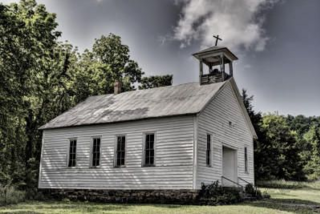
East Richwoods is an unincorporated community in Stone County, Arkansas, United States. East Richwoods is located on Arkansas Highway 9, 1.8 miles (2.9 km) southwest of Mountain View. The H.S. Mabry Barn, which is listed on the National Register of Historic Places, is located in East Richwoods.
Luber is an unincorporated community in Stone County, Arkansas, United States. Luber is located on unmarked gravel roads, 7.3 miles (11.7 km) south-southeast of Mountain View. The Luber School, which is listed on the National Register of Historic Places, is located in Luber.
Melrose is an unincorporated community in Stone County, Arkansas, United States. Melrose is located on Arkansas Highway 14, 11.9 miles (19.2 km) west of Batesville. The Walter Gray House, which is listed on the National Register of Historic Places, is located in Melrose.
Old Lexington is an unincorporated community in Stone County, Arkansas, United States. Old Lexington is located on Arkansas Highway 110, 6.8 miles (10.9 km) northwest of Shirley. The Joe Guffey House, which is listed on the National Register of Historic Places, is located in Old Lexington.
Optimus is an unincorporated community in Stone County, Arkansas, United States. Optimus is located on Arkansas Highway 5, 5.2 miles (8.4 km) south of Calico Rock. The Miles Jeffery Barn, which is listed on the National Register of Historic Places, is located in Optimus.

Turkey Creek is an unincorporated community in Stone County, Arkansas, United States. Turkey Creek is located on Arkansas Highway 9, 8.7 miles (14.0 km) southwest of Mountain View. The Turkey Creek School, which is listed on the National Register of Historic Places, is located in Turkey Creek.
St. James is an unincorporated community in Stone County, Arkansas, United States. St. James is located on Arkansas Highway 14, 11.4 miles (18.3 km) east of Mountain View. The Pinky Pruitt Barn, which is listed on the National Register of Historic Places, is located in St. James.
Allison is an unincorporated community in Stone County, Arkansas, United States. Allison is located along the White River at the junction of Arkansas highways 5, 9 and 14, 4.7 miles (7.6 km) north of Mountain View. The Sylamore Creek Bridge, which is listed on the National Register of Historic Places, is located in Allison.

Judd Hill is an unincorporated community in Poinsett County, Arkansas, United States. Judd Hill is located on Arkansas Highway 214, 5 miles (8.0 km) south of Trumann. The Judd Hill Cotton Gin, which is listed on the National Register of Historic Places, is located in Judd Hill. Judd Hill was named for banker and businessman Orange Judd Hill, who founded the community.
Barney is an unincorporated community in Faulkner County, Arkansas, United States. The community is located along Arkansas Highway 107 3.9 miles (6.3 km) north of Enola.
Hamlet is an unincorporated community in Faulkner County, Arkansas, United States. The community is located at the junction of U.S. Route 64 and Arkansas Highway 36, about halfway between Conway and Vilonia along the former.

Hollis is an unincorporated community in Perry County, Arkansas, United States. The community is located at the junction of Arkansas Highway 7 and Arkansas Highway 314, 20 miles (32 km) west-southwest of Perryville.

Highway 36 is a state highway in Central Arkansas. The highway begins at U.S. Highway 64 (US 64) at Hamlet and runs east through several small communities to Searcy, where it serves as the Beebe-Capps Expressway, a major crosstown arterial roadway. Following a discontinuity at US 64/US 67/US 167, the highway continues east to Kensett as Wilbur D. Mills Avenue before state maintenance ends at the small community of Georgetown. This highway is maintained by the Arkansas Department of Transportation (ARDOT).

