Schaberg, Arkansas

Last updated

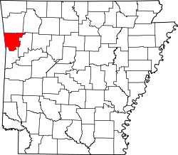
Schaberg is an unincorporated community in Crawford County, in the U.S. state of Arkansas. [1]

History

Variant names were "Frisco", "Porter" and "Porter Station". [1] The town site was platted as "Porter" in 1885, soon after the St. Louis–San Francisco Railway was extended to that point. [2] A post office called Frisco was established in 1883, the name was changed to Schaberg in 1912, and the post office closed in 1950. [3]

Related Research Articles

Crawford County, Arkansas U.S. county in Arkansas

Crawford County is a county located in the Ozarks region of the U.S. state of Arkansas. As of the 2010 census, the population was 61,948, making it the 12th-most populous of Arkansas's 75 counties. The county seat and largest city is Van Buren. Crawford County was formed on October 18, 1820 from the former Lovely County and Indian Territory, and was named for William H. Crawford, the United States Secretary of War in 1815.

Dyer, Arkansas City in Arkansas, United States

Dyer is a city in Crawford County, Arkansas, United States. It is part of the Fort Smith, Arkansas-Oklahoma Metropolitan Statistical Area. The population was 876 at the 2010 census.

Van Buren, Arkansas City in Arkansas, United States

Van Buren is the second largest city in the Fort Smith, Arkansas-Oklahoma Metropolitan Statistical Area and the county seat of Crawford County, Arkansas, United States. The city is located directly northeast of Fort Smith at the Interstate 40 - Interstate 540 junction. The city was incorporated in 1845 and as of the 2010 census had a population of 22,791, ranking it as the state's 22nd largest city, behind Searcy.

Dora is an unincorporated community in Crawford County in the western part of the U.S. state of Arkansas. It is located approximately three miles west of Van Buren on the Arkansas-Oklahoma border along Interstate 40. The community is part of the Fort Smith, Arkansas-Oklahoma Metropolitan Statistical Area. Dora shares its ZIP code (72956) and other municipal services with Van Buren.

Maysville, Arkansas Census-designated place in Arkansas, United States

Maysville is an unincorporated community in Benton County, Arkansas, United States. It is the westernmost settlement in the state of Arkansas. As of the 2010 census, its population is 130.

Barcelona is an unincorporated community in Crawford County, Arkansas, United States.

Bloomfield is an unincorporated community in Benton County, Arkansas, United States.

West Fork Township is an inactive township in Washington County, Arkansas, United States.

Starr Hill Township is an inactive township in Washington County, Arkansas, United States.

Winslow Township is an inactive township in Washington County, Arkansas, United States.

McGuire is an extinct town in Washington County, in the U.S. state of Arkansas.

Weddington is an unincorporated community in Washington County, in the U.S. state of Arkansas.

Wheeler is an unincorporated community in Washington County, in the U.S. state of Arkansas. The community is approximately four miles northwest of Fayetteville and lies adjacent to the Clear Creek floodplain.

Lancaster is an extinct town in Crawford County, in the U.S. state of Arkansas.

Armada is an extinct town in Crawford County, in the U.S. state of Arkansas.

Anna is an extinct town in Crawford County, in the U.S. state of Arkansas.

Belmont is an unincorporated community in Crawford County, in the U.S. state of Arkansas.

Bidville is an unincorporated community in Crawford County, in the U.S. state of Arkansas.

Vesta is an unincorporated community in Franklin County, in the U.S. state of Arkansas.

Witcherville is an unincorporated community in Sebastian County, in the U.S. state of Arkansas. An old variant name was "Salem".

References

  1. 1 2 U.S. Geological Survey Geographic Names Information System: Schaberg
  2. History of Benton, Washington, Carroll, Madison, Crawford, Franklin, and Sebastian Counties, Arkansas. Higginson Book Company. 1889. p. 554.
  3. "Post Offices". Jim Forte Postal History. Retrieved 6 February 2018.

Coordinates: 35°43′38″N94°10′11″W / 35.72730°N 94.16965°W / 35.72730; -94.16965