Cedarville, Arkansas

Last updated

Cedarville, Arkansas
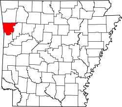
Crawford County Arkansas Incorporated and Unincorporated areas Cedarville Highlighted 0512520.svg
Location of Cedarville in Crawford County, Arkansas.
Coordinates: 35°34′59″N94°21′42″W / 35.58306°N 94.36167°W / 35.58306; -94.36167
Country United States
State Arkansas
County Crawford
Area
[1]
  Total8.89 sq mi (23.01 km2)
  Land8.89 sq mi (23.01 km2)
  Water0.00 sq mi (0.00 km2)
Elevation
[2]
860 ft (260 m)
Population
 (2020)
  Total1,424
  Density160.25/sq mi (61.88/km2)
Time zone UTC-6 (Central (CST))
  Summer (DST) UTC-5 (CDT)
ZIP code
72932
Area code 479
FIPS code 05-12520
GNIS feature ID2404016 [2]

Cedarville is a city in Crawford County, Arkansas, United States. It is part of the Fort Smith, Arkansas-Oklahoma Metropolitan Statistical Area. The population was 1,410 at the 2020 census. [3]

Contents

History

Cedarville was platted in 1879. [4] A post office has been in operation at Cedarville since 1872. [5]

Geography

Cedarville is located in western Crawford County on the southern edge of Ozark National Forest. Arkansas Highway 59 runs through the city, leading north 36 miles (58 km) towards Lincoln and south 10 miles (16 km) to Van Buren, the Crawford County seat.

According to the United States Census Bureau, Cedarville has a total area of 9.0 square miles (23.3 km2), all land. [6]

Demographics

Historical population
CensusPop.Note
1930 58
1940 11191.4%
1950 43−61.3%
1960 5220.9%
2000 1,133
2010 1,39423.0%
2020 1,4242.2%
U.S. Decennial Census [7]

As of the census [8] of 2000, there were 1,133 people, 406 households, and 328 families residing in the city. The population density was 129.1 inhabitants per square mile (49.8/km2). There were 442 housing units at an average density of 50.3 per square mile (19.4/km2). The racial makeup of the city was 94.53% White, 0.18% Black or African American, 2.74% Native American, 0.26% Asian, 0.18% from other races, and 2.12% from two or more races. 0.97% of the population were Hispanic or Latino of any race.

There were 407 households, out of which 39.9% had children under the age of 18 living with them, 68.0% were married couples living together, 9.6% had a female householder with no husband present, and 19.0% were non-families. 15.8% of all households were made up of individuals, and 5.3% had someone living alone who was 65 years of age or older. The average household size was 2.79 and the average family size was 3.10.

In the city, the population was spread out, with 29.3% under the age of 18, 7.9% from 18 to 24, 32.1% from 25 to 44, 22.6% from 45 to 64, and 8.1% who were 65 years of age or older. The median age was 33 years. For every 100 females, there were 105.6 males. For every 100 females age 18 and over, there were 99.3 males.

The median income for a household in the city was $30,952, and the median income for a family was $33,409. Males had a median income of $30,385 versus $16,538 for females. The per capita income for the city was $14,346. About 10.7% of families and 15.8% of the population were below the poverty line, including 19.9% of those under age 18 and 19.4% of those age 65 or over. The median gross rent was $750/mo (2011) and estimated rent burden was 19.0%. [9]

Education

Public education for early childhood, elementary and secondary school students is primarily provided by the Cedarville School District, which leads to graduation from Cedarville High School. The school's mascot and athletic emblem is the Pirates with royal blue and gold as the school colors.

Notable person

Related Research Articles

<span class="mw-page-title-main">Greene County, Ohio</span> County in Ohio, United States

Greene County is located in the southwestern portion of Ohio. As of the 2020 census, the population was 167,966. Its county seat is Xenia and its largest city is Beavercreek. The county was established on March 24, 1803 and named for General Nathanael Greene, an officer in the Revolutionary War. Greene County is part of the Dayton, OH Metropolitan Statistical Area.

<span class="mw-page-title-main">Crawford County, Arkansas</span> County in Arkansas, United States

Crawford County is a county located in the Ozarks region of the U.S. state of Arkansas. As of the 2020 census, the population was 60,133. The county seat and largest city is Van Buren. Crawford County was formed on October 18, 1820, from the former Lovely County and Indian Territory, and was named for William H. Crawford, the United States Secretary of War in 1815.

<span class="mw-page-title-main">Avoca, Arkansas</span> Town in Arkansas, United States

Avoca is a town in Benton County, Arkansas, United States. The population was 487 at the 2020 census. It is part of the Northwest Arkansas region.

<span class="mw-page-title-main">Garfield, Arkansas</span> Town in Arkansas, United States

Garfield is a town in Benton County, Arkansas, United States. The population was 593 at the 2020 census. It is part of the Northwest Arkansas region.

<span class="mw-page-title-main">Berryville, Arkansas</span> City in Arkansas, United States

Berryville is a city in Carroll County, Arkansas, United States. The population was 5,682 at the 2020 census. making it the largest city in Carroll County. Along with Eureka Springs, it is one of the two county seats of Carroll County.

<span class="mw-page-title-main">Quitman, Arkansas</span> City in Arkansas, United States

Quitman is a city in Cleburne and Faulkner counties in the U.S. state of Arkansas. Its population was 762 at the 2010 census. The portion of the city in Faulkner County is part of the Central Arkansas region.

<span class="mw-page-title-main">Dyer, Arkansas</span> City in Arkansas, United States

Dyer is a city in Crawford County, Arkansas, United States. It is part of the Fort Smith, Arkansas-Oklahoma Metropolitan Statistical Area. The population was 876 at the 2010 census.

<span class="mw-page-title-main">Kibler, Arkansas</span> City in Arkansas, United States

Kibler is a city in Crawford County, Arkansas, United States. It is part of the Fort Smith, Arkansas-Oklahoma Metropolitan Statistical Area. As of the 2010 Census the population was 961.

<span class="mw-page-title-main">Mountainburg, Arkansas</span> City in Arkansas, United States

Mountainburg is a town in Crawford County, Arkansas, United States. It is part of the Fort Smith, Arkansas-Oklahoma Metropolitan Statistical Area. As of the 2010 census the population was 631.

<span class="mw-page-title-main">Mulberry, Arkansas</span> City in Arkansas, United States

Mulberry is a city in Crawford County, Arkansas, United States. It is part of the Fort Smith, Arkansas-Oklahoma Metropolitan Statistical Area. The population was 1,655 as of the 2010 Census, an increase of 1.72% from 1,627 in 2000.

<span class="mw-page-title-main">Melbourne, Arkansas</span> City in Arkansas, United States

Melbourne is a city and county seat of Izard County, Arkansas, United States. The population was 1,848 at the 2010 census. It is home to the main campus of Ozarka College.

<span class="mw-page-title-main">Hindsville, Arkansas</span> Town in Arkansas, United States

Hindsville is a town in Madison County, Arkansas, United States. The population was 90 at the 2020 census. It is part of the Northwest Arkansas region.

<span class="mw-page-title-main">Jasper, Arkansas</span> City in Arkansas, United States

Jasper is a city in Newton County, Arkansas, United States. According to the 2020 census, its population is 547. The city is the county seat of Newton County.

<span class="mw-page-title-main">Mansfield, Arkansas</span> City in Arkansas, United States

Mansfield is a city in Scott and Sebastian counties Arkansas, United States. The Sebastian County portion of the city is part of the Fort Smith, Arkansas-Oklahoma Metropolitan Statistical Area. As of the 2010 Census, the population was 1,139. The population was 1,097 at the 2000 census.

<span class="mw-page-title-main">Hackett, Arkansas</span> City in Arkansas, United States

Hackett is a city in Sebastian County, Arkansas, United States. It is part of the Fort Smith, Arkansas-Oklahoma Metropolitan Statistical Area. The population was 812 at the 2010 census.

<span class="mw-page-title-main">Cedarville, Illinois</span> Village in Illinois, United States

Cedarville is a village in Stephenson County, Illinois, United States. The population was 741 at the 2010 census, up from 719 in 2000. It is the birthplace of social activist Jane Addams, the 1931 Nobel Peace Prize winner.

<span class="mw-page-title-main">Leo-Cedarville, Indiana</span> Town in Indiana, United States

Leo-Cedarville is a town in Cedar Creek Township, Allen County, Indiana, United States. The population was 3,603 at the 2010 census.

<span class="mw-page-title-main">Cedarville, Kentucky</span> Former city in Kentucky, United States

Cedarville is a former city in Pike County, Kentucky, United States. The population was 52 at the 2000 census. On December 14, 2009, Cedarville became a part of Elkhorn City.

<span class="mw-page-title-main">Cedarville, New Jersey</span> Populated place in Cumberland County, New Jersey, US

Cedarville is an unincorporated community and census-designated place (CDP) located within Lawrence Township, in Cumberland County, in the U.S. state of New Jersey. It is part of the Vineland-Millville-Bridgeton Primary Metropolitan Statistical Area for statistical purposes. As of the 2020 United States census, the CDP's population was 702.

<span class="mw-page-title-main">Cedarville, Ohio</span> Village in Ohio, United States

Cedarville is a village in Greene County, Ohio, United States. The village is within the Dayton Metropolitan Statistical Area. The population was 4,257 at the 2020 census.

References

  1. "2020 U.S. Gazetteer Files". United States Census Bureau. Retrieved October 29, 2021.
  2. 1 2 U.S. Geological Survey Geographic Names Information System: Cedarville, Arkansas
  3. "City and Town Population Totals: 2010-2019". The United States Census Bureau. US Census Bureau. Retrieved June 2, 2021.
  4. History of Benton, Washington, Carroll, Madison, Crawford, Franklin, and Sebastian Counties, Arkansas. Higginson Book Company. 1889. p. 552.
  5. "Post Offices". Jim Forte Postal History. Retrieved February 6, 2018.
  6. "Geographic Identifiers: 2010 Demographic Profile Data (G001): Cedarville city, Arkansas". U.S. Census Bureau, American Factfinder. Archived from the original on February 12, 2020. Retrieved June 18, 2014.
  7. "Census of Population and Housing". Census.gov. Retrieved June 4, 2015.
  8. "U.S. Census website". United States Census Bureau . Retrieved January 31, 2008.
  9. "Cedarville, Arkansas". Address-Data.com.[ permanent dead link ]
  10. "Ruth Reed Whitaker-obituary". Archived from the original on November 13, 2014. Retrieved November 12, 2014.