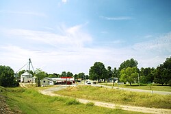
St. Francis, Arkansas

Last updated

St. Francis, Arkansas
St-Francis-Hwy-62-ar.jpg
St. Francis
Clay County Arkansas Incorporated and Unincorporated areas St. Francis Highlighted 0561970.svg
Location of St. Francis in Clay County, Arkansas.
Coordinates: 36°27′19″N90°08′32″W / 36.45528°N 90.14222°W / 36.45528; -90.14222
Country United States
State Arkansas
County Clay
Area
[1]
  Total0.37 sq mi (0.95 km2)
  Land0.35 sq mi (0.92 km2)
  Water0.01 sq mi (0.03 km2)
Elevation
[2]
299 ft (91 m)
Population
 (2020)
  Total218
  Density614.08/sq mi (237.32/km2)
Time zone UTC-6 (Central (CST))
  Summer (DST) UTC-5 (CDT)
ZIP code
72464 [3]
FIPS code 05-61970
GNIS feature ID2405393 [2]

St. Francis is a city in northeastern Clay County, Arkansas, United States, along the St. Francis River. The population was 250 at the 2010 census. [4]

Contents

History

The St. Francis area was settled in the 1840s, with the early residents forming the Chalk Bluff community just northwest of the present city. The Battle of Chalk Bluff was fought here in May 1863, during the Civil War. In 1882, the St. Louis Southwestern Railway ("Cotton Belt") was constructed through the area, and the Chalk Bluff community gradually shifted southeastward to a location along the railroad tracks. This new community was named "St. Francis" after the adjacent river (the river itself was named after Francis of Assisi). [5]

Geography

St. Francis is located near the northeastern corner of Clay County. It is bordered on the east by the St. Francis River, which forms the Arkansas–Missouri state line. U.S. Route 62 passes through the community, leading south and west 7 miles (11 km) to Piggott, and northeast 4 miles (6 km) to Campbell, Missouri. [6]

According to the United States Census Bureau, St. Francis has a total area of 0.37 square miles (0.95 km2), all land. [4]

Demographics

Historical population
CensusPop.Note
1890 356
1900 42018.0%
1910 4599.3%
1920 5019.2%
1930 294−41.3%
1940 266−9.5%
1950 2929.8%
1960 224−23.3%
1970 29732.6%
1980 266−10.4%
1990 201−24.4%
2000 25024.4%
2010 2500.0%
2020 218−12.8%
U.S. Decennial Census [7]

As of the census [8] of 2000, there were 250 people, 103 households, and 70 families residing in the city. The population density was 837.1 inhabitants per square mile (323.2/km2). There were 125 housing units at an average density of 418.5 per square mile (161.6/km2). The racial makeup of the city was 96.80% White, 1.20% Native American, and 2.00% from two or more races. 0.40% of the population were Hispanic or Latino of any race.

There were 103 households, out of which 34.0% had children under the age of 18 living with them, 55.3% were married couples living together, 10.7% had a female householder with no husband present, and 31.1% were non-families. 27.2% of all households were made up of individuals, and 13.6% had someone living alone who was 65 years of age or older. The average household size was 2.43 and the average family size was 2.94.

In the city, the population was spread out, with 25.6% under the age of 18, 12.0% from 18 to 24, 28.0% from 25 to 44, 21.6% from 45 to 64, and 12.8% who were 65 years of age or older. The median age was 33 years. For every 100 females, there were 95.3 males. For every 100 females age 18 and over, there were 91.8 males.

The median income for a household in the city was $30,278, and the median income for a family was $33,250. Males had a median income of $19,205 versus $13,563 for females. The per capita income for the city was $11,198. About 16.9% of families and 20.2% of the population were below the poverty line, including 25.0% of those under the age of eighteen and 38.2% of those 65 or over.

Education

It is in the Piggott School District. [9]

See also

Related Research Articles

<span class="mw-page-title-main">Clay County, Arkansas</span> County in Arkansas, United States

Clay County is a county located in the U.S. state of Arkansas. Originally incorporated as Clayton County, as of the 2020 census, its population was 14,552. The county has two county seats, Corning and Piggott. It is a dry county, in which the sale of alcoholic beverages is restricted or prohibited.

<span class="mw-page-title-main">St. Francis County, Arkansas</span> County in Arkansas, United States

St. Francis County is a county in the U.S. state of Arkansas. As of the 2020 census, the population was 23,090. The county seat is Forrest City.

<span class="mw-page-title-main">Corning, Arkansas</span> City in Arkansas, United States

Corning is a city in Clay County, Arkansas, United States. The population was 3,377 at the 2010 census. It is one of the two county seats of Clay County, along with Piggott.

<span class="mw-page-title-main">Greenway, Arkansas</span> City in Arkansas, United States

Greenway is a city in eastern Clay County, Arkansas, United States. The population was 209 at the 2010 census.

<span class="mw-page-title-main">McDougal, Arkansas</span> City in Arkansas, United States

McDougal is a city in Clay County, Arkansas, United States. The population was 186 at the 2010 census.

<span class="mw-page-title-main">Nimmons, Arkansas</span> Town in Arkansas, United States

Nimmons is a town in Clay County, Arkansas, United States. The population was 69 at the 2010 census, down from 100 in 2000.

<span class="mw-page-title-main">Piggott, Arkansas</span> City in Arkansas, United States

Piggott is a city in Clay County, Arkansas, United States. It is one of the two county seats of Clay County, along with Corning. It is the northern terminus of the Arkansas segment of the Crowley's Ridge Parkway, a National Scenic Byway. As of the 2010 census, Piggott's population was 3,849. The town was named after James A. Piggott, one of the early settlers and initiator of the local post office.

<span class="mw-page-title-main">Pollard, Arkansas</span> City in Arkansas, United States

Pollard is a city in Clay County, Arkansas, United States. The population was 222 at the 2010 census.

<span class="mw-page-title-main">Rector, Arkansas</span> City in Arkansas, United States

Rector is a city in southeastern Clay County, Arkansas, United States. The population was 1,977 at the 2010 census.

<span class="mw-page-title-main">Lake City, Arkansas</span> City in Arkansas, United States

Lake City is a city in Craighead County, Arkansas, United States, along the St. Francis River. Lake City is one of two county seats in Craighead County. The population was 2,326 as of the 2020 census. It is included in the Jonesboro, Arkansas Metropolitan Statistical Area.

<span class="mw-page-title-main">Marmaduke, Arkansas</span> City in Arkansas, United States

Marmaduke is a city in Greene County, Arkansas, United States. The population was 1,212 in 2020.

<span class="mw-page-title-main">White Hall, Arkansas</span> City in Arkansas, United States

White Hall is a city in Washington Township, located in Jefferson County, Arkansas, United States. With a population of 5,526 in the 2010 census, it is included in the Pine Bluff Metropolitan Statistical Area and the greater Little Rock-North Little Rock-Pine Bluff Combined Statistical Area. White Hall is home to the Pine Bluff Arsenal.

<span class="mw-page-title-main">Marianna, Arkansas</span> Town in Arkansas, United States

Marianna is a town in and the county seat of Lee County, Arkansas, United States. As of the 2010 census it had a population of 4,115, but by 2018 the population had dropped to an estimated 3,477.

<span class="mw-page-title-main">Winthrop, Arkansas</span> City in Arkansas, United States

Winthrop is a city in Little River County, Arkansas, United States. The population was 192 at the 2010 census. The community was a backdrop for the Winthrop Rockefeller election campaigns in the 1960s.

<span class="mw-page-title-main">Morrison Bluff, Arkansas</span> Town in Arkansas, United States

Morrison Bluff is a town in Logan County, Arkansas, United States. The population was 64 at the 2010 census and an estimated 81 in 2017.

<span class="mw-page-title-main">Bluff City, Arkansas</span> Town in Arkansas, United States

Bluff City is an unincorporated town in Nevada County, Arkansas, United States. The population was 158 at the 2000 census. It is part of the Hope Micropolitan Statistical Area.

<span class="mw-page-title-main">Marked Tree, Arkansas</span> City in Arkansas, United States

Marked Tree is a city in Poinsett County, Arkansas, United States, along the St. Francis River, at the mouth of the Little River. The population was 2,286 at the 2020 census. It is included in the Jonesboro, Arkansas, metropolitan statistical area.

<span class="mw-page-title-main">DeValls Bluff, Arkansas</span> City in Arkansas, United States

DeValls Bluff is a city in and the county seat of the southern district of Prairie County, Arkansas, United States. The population was 619 at the 2010 census.

<span class="mw-page-title-main">Judsonia, Arkansas</span> City in Arkansas, United States

Judsonia is a city in White County, Arkansas, United States. Stan Robinson is the current mayor, first elected in 2018. The population was 1,854 at the 2020 census. The city is located immediately northeast of neighboring Searcy, and north of the Little Red River before it turns southeast toward the White River.

QulinKEW-lin is a city located in Butler County in Southeast Missouri, United States. The population was 460 at the 2020 census.

References

  1. "2020 U.S. Gazetteer Files". United States Census Bureau. Retrieved October 29, 2021.
  2. 1 2 U.S. Geological Survey Geographic Names Information System: St. Francis, Arkansas
  3. "Saint Francis ZIP Code". zipdatamaps.com. 2022. Retrieved November 30, 2022.
  4. 1 2 "Geographic Identifiers: 2010 Demographic Profile Data (G001): St. Francis city, Arkansas". U.S. Census Bureau, American Factfinder. Archived from the original on February 12, 2020. Retrieved June 16, 2014.
  5. Steven Teske, "St. Francis (Clay County)," Encyclopedia of Arkansas History and Culture, 2017.
  6. Arkansas Atlas & Gazetteer, DeLorme, 2nd ed., 2004, p.29 ISBN   0899333451
  7. "Census of Population and Housing". Census.gov. Retrieved June 4, 2015.
  8. "U.S. Census website". United States Census Bureau . Retrieved January 31, 2008.
  9. "SCHOOL DISTRICT REFERENCE MAP (2010 CENSUS): Clay County, AR" (PDF). U.S. Census Bureau . Retrieved March 4, 2021.