Bridgeton Covered Bridge

Last updated
Bridgeton Covered Bridge
RebuiltBridgetonCoveredBridge.jpg
Rebuilt Bridgeton Covered Bridge (2006-Present)
Coordinates 39°38′57.82″N87°10′34.43″W / 39.6493944°N 87.1762306°W / 39.6493944; -87.1762306
CarriesPedestrian traffic
CrossesBig Raccoon Creek
LocaleBridgeton, Indiana
Official nameBridgeton Bridge
Named for Bridgeton, Indiana
Characteristics
Design Burr arch truss bridge
MaterialSandstone block (foundations)
Trough constructionWood
Pier constructionUnknown
Total length267 ft (81.4 m) (includes 11 ft (3.4 m) overhangs on each end)
Width13 ft (4.0 m)
Longest span122.5 ft (37.3 m)
No. of spans2
Piers in water1
Clearance above 12 ft (3.7 m)
History
Designer
  • Steve Arnold
  • Chuck Ennis
  • Mike Cooper
  • Ron May
  • Ben Hill [1]
Constructed byDan Collom & local community
Construction cost$125,000
OpenedOctober 1, 2006
Location
Bridgeton Covered Bridge
Bridgetoncoveredbridge1.jpg
Old bridge
Coordinates 39°38′56″N87°10′34″W / 39.649°N 87.176°W / 39.649; -87.176
CarriesBridgeton Road
Bridge bypassed in 1967
CrossesBig Raccoon Creek
LocaleBridgeton, Indiana
Official nameBridgeton Bridge
Named for Bridgeton, Indiana
WGCB # 14-61-04 [2]
Characteristics
Design Burr arch truss bridge
MaterialSandstone block (foundations)
Trough constructionWood
Pier constructionUnknown
Total length267 ft (81.4 m) (includes 11 ft (3.4 m) overhangs on each end)
Width13 ft (4.0 m)
Longest span122.5 ft (37.3 m)
No. of spans2
Piers in water1
Clearance above 12 ft (3.7 m)
History
Construction cost$10,200
Bridgeton Covered Bridge (#8)
Locator map of Parke County, Indiana.svg
Red pog.svg
Location of Bridgeton Covered Bridge
USA Indiana location map.svg
Red pog.svg
Location of Bridgeton Covered Bridge
Usa edcp location map.svg
Red pog.svg
Location of Bridgeton Covered Bridge
Built1868 (1868)
Built by J. J. Daniels
DemolishedApril 28, 2005 (2005-04-28) (Arson)
Website Bridgeton Bridge
Part ofParke County Covered Bridges TR (ID64000193)
NRHP reference No. 78000386 [3]
Added to NRHPDecember 22, 1978

The first Bridgeton covered bridge was a double-span Burr Arch bridge built in 1868 by a crew led by J. J. Daniels. It was closed to traffic in 1967. It was built to replace two prior open wooden bridges that had fallen in. [4] After its destruction by fire, it was replaced in 2006 by a reproduction.

Contents

First bridge

About 1823, Kockwood and Silliman built the first mill, in the location that would develop a bad reputation and often be referred to as "Sodom", on Big Raccoon Creek. Later, in an attempt to change the town's reputation, the town would become Bridgeton after the earlier bridge. The first mill was owned by Oniel and Wasson and later be bought by James Searing. From 1850 to 1860, James A. Rea would run the mill. In 1862, the mill would change hands to Ralph Sprague and burn down in 1869. James Rea would go on to rebuild the mill in 1871, and Joseph Cole would operate it. Daniel Webster bought it in 1882, and sold it to P.T. Winney in 1889. The mill would not change hands again until June 1914, when George Brake and Fred Mitchell purchased it. According to Mr. Brake, the south half of the dam was built in 1913, with the remaining half finished in 1916. The dam is constructed of concrete and is 225 ft (69 m) long and 9 ft (2.7 m) high. [5]

The first bridge to be built was of open design with wood rails and piers. While crossing the first bridge Owen Wimmer and his family were dropped into the mill pond along with their wagon and team when the bridge fell in. J.H. Kerr and others were able to rescue them. A second bridge of similar construction was erected at the same site. This bridge fell in also just after J.H. Kerr had driven cattle across. The covered bridge was then built in 1868, at the same location, just above the mill dam, with the abutments attached to the dam structure.

Three people submitted bids in 1868, for the contract to build the bridge, these bids would include three different styles of bridges. One bid was from a Mr. Epperson using an Howe Plan for $16,000. Wheelock and McCoy submitted two plans, one was to use a Burr Plan for $17,400 and the second using a Smith Plan for $10,200. Ultimately the bid was awarded to J. J. Daniels and his Burr Plan for $10,200. The "Daniels Portals" were to be later squared off and, after the bridge's closing in 1967, to traffic, benches and steps were added at the portals.

The present mill has been converted to run on electric power. Robert Weis and the Weis Milling Company operated the mill until 1995 when it was purchased by Mike Roe. The current owner has restored the mill and produces over 20 different milled products.

The bridge was destroyed by arson on April 28, 2005. Jesse Payne was taken into custody near the Mansfield Covered Bridge a short time later. He is suspected of burning the Jeffries Ford Covered Bridge also and attempted arson of the Mansfield Covered Bridge. Due to his mental state, he is being detained at the Logansport State Hospital until he is found fit to stand trial. [6] [7]

Second bridge

The second Bridgeton covered bridge was built in 2006 by local citizens and the state of Indiana. [8] [9]

See also

Related Research Articles

<span class="mw-page-title-main">Bridgeton, Indiana</span> Unincorporated community in Indiana, United States

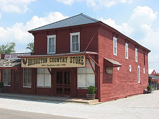
Bridgeton is an unincorporated community in Raccoon Township, Parke County, in the U.S. state of Indiana. It is notable for its covered bridge, which was destroyed on April 28, 2005, by a fire set by an arsonist. A historically accurate reconstruction of the bridge was completed in October, 2006.

<span class="mw-page-title-main">Mansfield Covered Bridge</span> Bridge in Indiana, United States

The Mansfield Covered Bridge is a Double Burr Arch double span truss bridge located on Mansfield Road (historic) and Big Raccoon Creek in Mansfield southeast of Rockville in Parke County, Indiana. Built by Joseph J. Daniels in 1867 at a cost of $12,200. At 279 ft (85 m) it is the second longest covered bridge left in Parke County. This Historic Site rest on land provided by Indiana DNR, of Parke County, Indiana and is open to the public all year.

<span class="mw-page-title-main">Big Rocky Fork Covered Bridge</span> Place in Indiana listed on National Register of Historic Places

The Big Rocky Fork Covered Bridge is located 1 mile (1.6 km) southeast of Mansfield, Indiana, on County Road 720 and about 2 miles (3.2 km) east of State Road 59, in Parke County.

<span class="mw-page-title-main">Conley's Ford Covered Bridge</span> Bridge in Parke County, Indiana

Conley's Ford Covered Bridge was built in 1906 and crosses Big Raccoon Creek on County Road 550 East close to County Road 720 South, in Parke County, IN. The bridge is a single span Burr Arch Truss structure. The Conley's Ford Covered Bridge was built by J. Lawrence Van Fossen.

<span class="mw-page-title-main">Nevins Covered Bridge</span> Place in Indiana listed on National Register of Historic Places

The Nevins Covered Bridge is a single span Burr Arch Truss covered bridge that crosses Little Raccoon Creek on County Road 130 East, just southeast of Catlin, Indiana. It was built in 1920 by Joseph A. Britton and Son. Prior to the reconstruction of the Bridgeton Bridge in 2006, the Nevins Bridge was the newest covered bridge in Parke County.

<span class="mw-page-title-main">Parke County Covered Bridges</span>

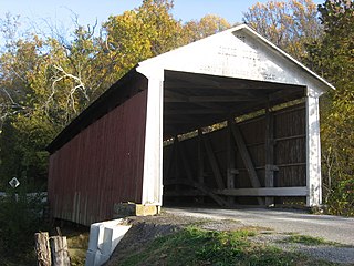
The covered bridges of Parke County are well-known tourist attractions in Parke County, Indiana, United States, which touts itself as the "Covered Bridge Capital of the World". The county claims to have more covered bridges than any other county in the United States. This is due to several reasons, mainly due to the numerous streams and creeks in the county, and having the natural resources and designers to build the bridges.

<span class="mw-page-title-main">Jackson Covered Bridge</span> Place in Indiana listed on National Register of Historic Places

The Jackson Covered Bridge also known as the Rockport Covered Bridge is located in the 'forgotten town' of Rockport, northwest of Bloomingdale, Parke County, Indiana, USA.

<span class="mw-page-title-main">Jeffries Ford Covered Bridge</span> Bridge in Raccoon, Indiana

The Jeffries Ford Covered Bridge was southwest of Bridgeton, Indiana, United States. The double-span Burr Arch covered bridge structure was built by J. A. Britton in 1915 and destroyed by arson on April 2, 2002.

<span class="mw-page-title-main">Leatherwood Station Covered Bridge</span> Place in Indiana listed on National Register of Historic Places

The Leatherwood Station Covered Bridge is a single span double Burr Arch Truss covered bridge structure that was built by Joseph A. Britton & Son in 1899. Originally it had sandstone abutments but when it was moved to Billie Creek Village they were replaced with concrete abutments with sandstone showing.

<span class="mw-page-title-main">Melcher Covered Bridge</span> Place in Indiana listed on National Register of Historic Places

The Melcher Covered Bridge, also known as the "Klondyke Covered Bridge", "Marion Covered Bridge", or the "Leatherwood Covered Bridge" crosses Leatherwood Creek east of Montezuma, Indiana, and is a single-span Burr Arch Truss covered bridge structure that was built by Joseph J. Daniels in 1896.

<span class="mw-page-title-main">Mill Creek Covered Bridge</span> Place in Indiana listed on National Register of Historic Places

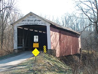
The Mill Creek Covered Bridge also known as "Thompson's Ford Covered Bridge," "Tow Path Covered Bridge," or "Earl Ray Covered Bridge" crosses Wabash Mill Creek (historic) southwest of Tangier, Indiana. It is a single span Burr Arch Truss covered bridge structure that was built by D. M. Brown in 1907.

<span class="mw-page-title-main">Portland Mills Covered Bridge</span> Bridge in Indiana, United States

The Portland Mills Covered Bridge is the second oldest covered bridge in Parke County, Indiana, being built the same year as the Crooks Covered Bridge. It is a single span Burr Arch Truss covered bridge that was built by Henry Wolf in 1856.

<span class="mw-page-title-main">Roseville-Coxville Covered Bridge</span> Bridge southeast of Mecca, Indiana

The Roseville Covered Bridge, also known as the Coxville covered bridge, is southeast of Mecca, Indiana. The double span Burr Arch covered bridge structure was built by Joseph J. Daniels in 1910. This is the third bridge at this location.

<span class="mw-page-title-main">Rush Creek Covered Bridge</span> Place in Indiana listed on National Register of Historic Places

The Rush Creek Covered Bridge is south of Tangier, Indiana. The single span Burr Arch covered bridge structure was built by William Hendricks in 1904.

Joseph Albert Britton (1839–1929), most commonly known as J.A. Britton, was a builder of bridges in Indiana. He created many works that survive and are listed on the U.S. National Register of Historic Places.

Joseph J. Daniels (1826–1916), most commonly known as J. J. Daniels, was an American bridge builder active in Indiana. A number of his works are listed on the U.S. National Register of Historic Places.

The Armiesburg Covered Bridge was on the south side of Armiesburg, Indiana. The Long Truss with arch covered bridge structure was built by Henry Wolf in 1907 and destroyed by the Great Flood of 1913.

The Hollandsburg Covered Bridge was southeast of Hollandsburg, Indiana. The single-span Burr Arch covered bridge structure was built by J. J. Daniels in 1872 and torn down in 1930 during the expansion of U.S. Route 36 (US 36).

The Red Covered Bridge was east of Rosedale, Indiana. The double-span Burr Arch covered bridge structure was built by J. J. Daniels in 1880 and destroyed by arson on October 13, 1976.

References

  1. https://www.tribstar.com/news/bridgeton-bridge-construction-to-begin-soon/article_5c04ed1e-09dd-5404-a8d2-bc2776766090.htm
  2. "The Bridgeton Bridge". Indiana Covered Bridge Society. Retrieved 1 July 2021.
  3. "National Register Information System  Bridgeton Covered Bridge (#8) (#78000386)". National Register of Historic Places . National Park Service. January 23, 2007. Retrieved September 17, 2018.
  4. "Bridgeton Covered Bridge (#8)". Covered Bridges. Retrieved 25 November 2019.
  5. "Indiana State Historic Architectural and Archaeological Research Database (SHAARD)" (Searchable database). Department of Natural Resources, Division of Historic Preservation and Archaeology. Retrieved 2016-06-01.Note: This includes Charles Felkner (December 1977). "National Register of Historic Places Inventory Nomination Form: Parke County Covered Bridge Historic District" (PDF). Retrieved 2016-06-01., Site map, and Accompanying photographs.
  6. Harkrider, Cathy (4 August 2006). "Update on Covered Bridge Arsonist" . Retrieved 1 July 2021.
  7. "Jesse L. Payne v. State of Indiana". 11 October 2006. Retrieved 1 July 2021.
  8. Rebuilding the Bridgeton Covered Bridge - BridgetonIndiana.com
  9. Wabash Men Join Community in Rebuilding Covered Bridge

Further reading

Commons-logo.svg Media related to Bridgeton Covered Bridge at Wikimedia Commons