Grange Corner Covered Bridge

Last updated
Grange Corner Covered Bridge
Coordinates 39°56′23.17″N87°12′31.46″W / 39.9397694°N 87.2087389°W / 39.9397694; -87.2087389 Coordinates: 39°56′23.17″N87°12′31.46″W / 39.9397694°N 87.2087389°W / 39.9397694; -87.2087389
Carries C.R. 1200N
Crosses Sugar Mill Creek
Locale Parke, Indiana, United States
Official name Grange Corner Covered Bridge
Other name(s) Delp Covered Bridge
Named for Grange Corner, Indiana
WGCB Number 14-61-37 [1]
Characteristics
Total length 113 ft (34 m)
History
Constructed by J. J. Daniels
Built 1899
USA Indiana location map.svg
Red pog.svg
Grange Corner Covered Bridge
Location of the Grange Corner Bridge in Indiana

The Grange Corner Covered Bridge was west of Grange Corner, Indiana. The single-span Burr Arch covered bridge structure was built by the J. J. Daniels in 1899 and destroyed by flood in 1968. [1] [2]

Grange Corner, Indiana Unincorporated community in Indiana, United States

Grange Corner is an unincorporated community in southeastern Lost Creek Township, Vigo County, in the U.S. state of Indiana.

Joseph J. Daniels (1826–1916), most commonly known as J. J. Daniels, was an American bridge builder active in Indiana. A number of his works are listed on the U.S. National Register of Historic Places.

Contents

History

Construction

J. J. Daniels had placed two bids for the construction of the bridge. The first was for $1,485 for just the superstructure and the second was $2,520 for the superstructure and the abutments. Meanwhile, Thomas Alward had placed a bid for $945 for the abutments. With Daniels bid of $1,485 and Alward's for $945 totaling $2,430 the contract was split between the two contractors. This was a common practice to award the bridge and abutments separately and even when awarded to one bidder the abutments sometimes were subcontracted anyway.

Destruction

Even though the Grange Corner Covered Bridge was eventually lost to a flood in 1968 when one of the abutments washed away the real reason can be traced back to politics. It could be said that the bridge was lost to a bureaucratic game of "chicken." The abutments had been inspected and declared unsafe, but with the Parke County Highway Department trying to maintain county roads with a limited budget often conflicting with Parke County Incorporated's goal of maintaining covered bridge, Grange Corner Covered Bridge was stuck in the middle. Repairs had to be deferred while funding for the repairs was sought. However, the flood came before the funds and the bridge fell into the creek bed.

Witnesses would later claim that the bridge was not destroyed and they felt the bridge could have been jacked out of the creek bed and removed as a complete unit in hopes of preserving or moving the bridge. Conflicting photographs show that the bridge was in much worse conditions though. But with no funds available to do this the County would only release enough funds to demolish the bridge.

See also

Parke County Covered Bridges

The covered bridges of Parke County are well-known tourist attractions in Parke County, Indiana, United States, which touts itself as the "Covered Bridge Capital of the World". The county claims to have more covered bridges than any other county in the United States. This is due to several reasons, mainly due to the numerous streams and creeks in the county, and having the natural resources and designers to build the bridges.

The Parke County Covered Bridge Festival is a fall festival which takes place in nine communities in Parke County, Indiana, United States. It celebrates the county's 31 covered bridges, and is attended by more than 2 million people each year. It begins on the 2nd Friday in October and lasts 10 days.

Related Research Articles

Mansfield Covered Bridge place in Indiana listed on National Register of Historic Places

The Mansfield Covered Bridge is a Double Burr Arch double span truss bridge located on Mansfield Road (historic) and Big Raccoon Creek in Mansfield southeast of Rockville in Parke County, Indiana. Built by Joseph J. Daniels in 1867 at a cost of $12,200. At 279 ft (85 m) it is the second longest covered bridge left in Parke County. This Historic Site rest on land provided by Luke J. Moody and is open to the public.

Bridgeton Covered Bridge place in Indiana listed on National Register of Historic Places

The first Bridgeton Covered Bridge was a long double span Burr Arch bridge built in 1868 by a crew led by J. J. Daniels. The bridge was closed to traffic in 1967. It had been built to replace two prior open wooden bridges that had fallen in. After its destruction by fire, it was replaced in 2006 by a reproduction.

Crooks Covered Bridge place in Indiana listed on National Register of Historic Places

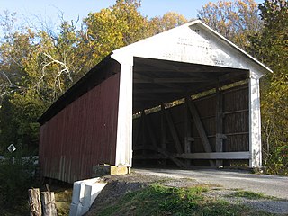
The Crooks Covered Bridge is a single span Burr Arch Truss structure that crosses Little Raccoon Creek built in 1855-1856 by Henry Wolf just southeast of Rockville, Indiana.

Billie Creek Covered Bridge place in Indiana listed on National Register of Historic Places

The Billie Creek Covered Bridge is a Burr Arch structure that was built by Joseph J. Daniels in 1895. J.L. Van Fossen supplied the sandstone that makes up the abutments cut from A.E. Fuel's nearby quarry.

Jackson Covered Bridge place in Indiana listed on National Register of Historic Places

The Jackson Covered Bridge also known as the Rockport Covered Bridge is located in the 'forgotten town' of Rockport, northwest of Bloomingdale, Parke County, Indiana, USA.

Leatherwood Station Covered Bridge place in Indiana listed on National Register of Historic Places

The Leatherwood Station Covered Bridge is a single span double Burr Arch Truss covered bridge structure that was built by Joseph A. Britton & Son in 1899. Originally it had sandstone abutments but when it was moved to Billie Creek Village they were replaced with concrete abutments with sandstone showing.

Mill Creek Covered Bridge place in Indiana listed on National Register of Historic Places

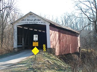
The Mill Creek Covered Bridge also known as "Thompson's Ford Covered Bridge," "Tow Path Covered Bridge," or "Earl Ray Covered Bridge" crosses Wabash Mill Creek (historic) southwest of Tangier, Indiana. It is a single span Burr Arch Truss covered bridge structure that was built by D. M. Brown in 1907.

Narrows Covered Bridge place in Indiana listed on National Register of Historic Places

The Narrows Covered Bridge crosses Sugar Creek at the eastern edge of Turkey Run State Park and is a single span Burr Arch Truss covered bridge structure that was built by Joseph A. Britton in 1882.

Roseville-Coxville Covered Bridge bridge southeast of Mecca, Indiana

The Roseville Covered Bridge, also known as the Coxville covered bridge, is southeast of Mecca, Indiana. The double span Burr Arch covered bridge structure was built by Joseph J. Daniels in 1910. This is the third bridge at this location.
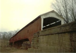
West Union Covered Bridge (Indiana) place in Indiana listed on National Register of Historic Places

The West Union Covered Bridge is north-northeast of Montezuma, Indiana. The two-span Burr Arch Truss covered bridge structure was built by Joseph J. Daniels in 1876. It is notable for being the longest standing covered bridge in Parke County, and one of the nation's best-preserved examples of the Burr truss.

Clinton Covered Bridge

The Clinton Covered Bridge was on the east side of Clinton, Indiana. The Long Truss style bridge with double lanes, triple covered spans and one 70 foot draw span was built by Hirem Bishop in 1852-53 and destroyed by electric cutting wire in 1899.

Coal Creek Covered Bridge bridge in United States of America

The Coal Creek Covered Bridge was on the east side of Lodi, Indiana. The Burr Arch single span style bridge crossed Coal Creek and was built by J. J. Daniels in 1869. It was destroyed by arson on June 28, 1992.

Harrison Covered Bridge

The Harrison Covered Bridge was north of West Union, Indiana. The double-span Burr Arch covered bridge structure was built by J. J. Daniels in 1866 and damaged by flood waters in December 1875.

Hollandsburg Covered Bridge

The Hollandsburg Covered Bridge was southeast of Hollandsburg, Indiana. The single-span Burr Arch covered bridge structure was built by J. J. Daniels in 1872 and torn down in 1930 during the expansion of U.S. Route 36 (US 36).

Jessup Covered Bridge bridge in United States of America

The Jessup Covered Bridge was north of Jessup, Indiana. The single-span Burr Arch covered bridge structure was built by the Jefferson P. Van Fossen in 1910 and destroyed by flood in 1989.

Plank Road Covered Bridge bridge in United States of America

The Plank Road Covered Bridge was east of Rockville, Indiana. The single-span Burr Arch covered bridge structure was built by Henry Wolf in either 1854 or 1859 and destroyed in the Great Flood of 1913.

Red Covered Bridge (Rosedale, Indiana) bridge in United States of America

The Red Covered Bridge was east of Rosedale, Indiana. The double-span Burr Arch covered bridge structure was built by J. J. Daniels in 1880 and destroyed by arson on October 13, 1976.

Star Mill Covered Bridge bridge in United States of America

The Star Mill Covered Bridge was north of West Union, Indiana. The double-span Burr Arch covered bridge structure was built by J. J. Daniels in 1861 and destroyed by flood waters in 1866.

Turkey Run Covered Bridge bridge in United States of America

The Turkey Run Covered Bridge was north of Marshall, Indiana. The single-span Modified Queen Truss covered bridge structure was built by Joseph J. Daniels in 1865, 1866 or 1884, according to several conflicting sources, and dismantled in 1914 by order of the Parke County Commissioners, the abutments remain. It was one of two Queen Truss type covered bridges, the other being the JH Russell Covered Bridge

References

  1. 1 2 "Grange Corner Covered Bridge". Parke County Convention & Visitors Commission. Retrieved 11 February 2015.
  2. "Grange Corner or Delph". Indiana Covered Bridges. 11 February 2015. Retrieved 11 February 2015.