
Vermillion County lies in the western part of the U.S. state of Indiana between the Illinois border and the Wabash River. As of the 2020 census, the population was 15,439. The county seat is Newport. It was officially established in 1824 and was the fiftieth Indiana county created. Vermillion County is included in the Terre Haute, Indiana, Metropolitan Statistical Area. The county contains seven incorporated towns with a total population of about 9,900. as well as several unincorporated communities; it is also divided into five townships which provide local services. An interstate highway, two U.S. routes, and five state roads cross the county, as does a major railroad line.

Parke County lies in the western part of the U.S. state of Indiana along the Wabash River. The county was formed in 1821 out of a portion of Vigo County. According to the 2020 census, the population was 16,156. The county seat is Rockville.

The first Bridgeton covered bridge was a double-span Burr Arch bridge built in 1868 by a crew led by J. J. Daniels. It was closed to traffic in 1967. It was built to replace two prior open wooden bridges that had fallen in. After its destruction by fire, it was replaced in 2006 by a reproduction.

The Nevins Covered Bridge is a single span Burr Arch Truss covered bridge that crosses Little Raccoon Creek on County Road 130 East, just southeast of Catlin, Indiana. It was built in 1920 by Joseph A. Britton and Son. Prior to the reconstruction of the Bridgeton Bridge in 2006, the Nevins Bridge was the newest covered bridge in Parke County.

The Jackson Covered Bridge also known as the Rockport Covered Bridge is located in the 'forgotten town' of Rockport, northwest of Bloomingdale, Parke County, Indiana, USA.

The Leatherwood Station Covered Bridge is a single span double Burr Arch Truss covered bridge structure that was built by Joseph A. Britton & Son in 1899. Originally it had sandstone abutments but when it was moved to Billie Creek Village they were replaced with concrete abutments with sandstone showing.
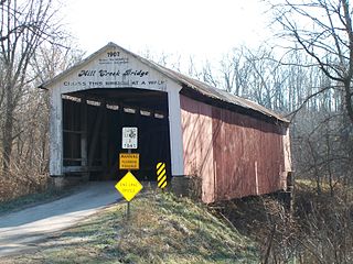
The Mill Creek Covered Bridge also known as "Thompson's Ford Covered Bridge," "Tow Path Covered Bridge," or "Earl Ray Covered Bridge" crosses Wabash Mill Creek (historic) southwest of Tangier, Indiana. It is a single span Burr Arch Truss covered bridge structure that was built by D. M. Brown in 1907.

The Portland Mills Covered Bridge is the second oldest covered bridge in Parke County, Indiana, being built the same year as the Crooks Covered Bridge. It is a single span Burr Arch Truss covered bridge that was built by Henry Wolf in 1856.
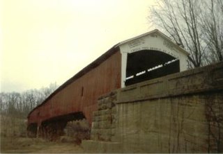
The West Union Covered Bridge formerly carried Tow Path Road over Sugar Creek north-northeast of Montezuma, Indiana. The two-span Burr Arch Truss covered bridge structure was built by Joseph J. Daniels in 1876. It is notable for being the longest standing covered bridge in Parke County, and one of the nation's best-preserved examples of the Burr truss.
The Armiesburg Covered Bridge was on the south side of Armiesburg, Indiana. The Long Truss with arch covered bridge structure was built by Henry Wolf in 1907 and destroyed by the Great Flood of 1913.
The Greencastle Road Covered Bridge is a "lost" bridge in the truest of senses, not only is it gone, but the exact records of where, if at all, it existed have been lost to history. Henry Wolf probably built it sometime before 1863 on a section of Greencastle Road that no longer exists.
The Hollandsburg Covered Bridge was southeast of Hollandsburg, Indiana. The single-span Burr Arch covered bridge structure was built by J. J. Daniels in 1872 and torn down in 1930 during the expansion of U.S. Route 36 (US 36).
The J. H. Russell Covered Bridge was north of Annapolis, Indiana. The single-span Modified Queen Truss covered bridge structure was built by Pearly Weaver and George Weaver in 1897 and destroyed by deterioration. It was one of five bridges in Parke County to be on private land. The others were the State Sanitorium Covered Bridge, Lusk Covered Bridge 1840, Lusk Covered Bridge 1847, and the Clinton Toll Bridge. It was also one of two Queen Truss tupe covered bridges, the other being the Turkey Run Covered Bridge
The Plank Road Covered Bridge was east of Rockville, Indiana. The single-span Burr Arch covered bridge structure was built by Henry Wolf in either 1854 or 1859 and destroyed in the Great Flood of 1913.
The Red Covered Bridge was east of Rosedale, Indiana. The double-span Burr Arch covered bridge structure was built by J. J. Daniels in 1880 and destroyed by arson on October 13, 1976.
The Star Mill Covered Bridge was north of West Union, Indiana. The double-span Burr Arch covered bridge structure was built by J. J. Daniels in 1861 and destroyed by flood waters in 1866.
The Turkey Run Covered Bridge was north of Marshall, Indiana. The single-span Modified Queen Truss covered bridge structure was built by Joseph J. Daniels in 1865, 1866 or 1884, according to several conflicting sources, and dismantled in 1914 by order of the Parke County Commissioners, the abutments remain. It was one of two Queen Truss type covered bridges, the other being the JH Russell Covered Bridge
The Union Township Covered Bridge was southeast of Hollandsburg, Indiana. The single-span Burr Arch covered bridge structure was built by J. J. Daniels in 1851 and torn down in 1872 during the rebuilding of the Plank Road into a toll-free road.
The Lusk Covered Bridge was once located north of Marshall, Indiana, United States. Two single-span dual lane Lattice Truss covered bridges were located at the site, one of which replaced the other. Salmon Lusk constructed the first bridge in 1840, and after its destruction by flood in 1847, Lusk constructed the second. Both bridges were located on private land; the only other such covered bridges in Parke County were the State Sanitorium Covered Bridge, the JH Russell Covered Bridge, and the Clinton Toll Bridge.

