Harrison Covered Bridge | |
---|---|
Coordinates | 39°51′17.75″N87°20′8.75″W / 39.8549306°N 87.3357639°W Coordinates: 39°51′17.75″N87°20′8.75″W / 39.8549306°N 87.3357639°W |
Carries | Tow Path Road |
Crosses | Sugar Creek |
Locale | West Union, Indiana, Parke, Indiana, United States |
Official name | Harrison Covered Bridge |
Named for | William Henry Harrison |
Characteristics | |
Total length | 250 ft (76 m) |
History | |
Constructed by | J. J. Daniels |
Built | 1866 |
Construction cost | $5,725 |
Closed | September 1876 |
The Harrison Covered Bridge was north of West Union, Indiana. The double-span Burr Arch covered bridge structure was built by J. J. Daniels in 1866 and damaged by flood waters in December 1875. [1]
West Union is an unincorporated community in Reserve Township, Parke County, in the U.S. state of Indiana.
Joseph J. Daniels (1826–1916), most commonly known as J. J. Daniels, was an American bridge builder active in Indiana. A number of his works are listed on the U.S. National Register of Historic Places.
The bridge was built to replace the Star Mill Covered Bridge that had been destroyed by flood waters in 1866. J. J. Daniels was paid $269.66 by the Parke County Commissioners to remove the destroyed bridge from the creek bed.
The Star Mill Covered Bridge was north of West Union, Indiana. The double-span Burr Arch covered bridge structure was built by J. J. Daniels in 1861 and destroyed by flood waters in 1866.
On July 14, 1866, the County Commissioners awarded Daniels with the contract to replace the bridge for $5,725. The bridge would be completed in 1866 and named the Harrison Bridge in honor of the Indiana Territorial Governor and later President William Henry Harrison. Because of the name change the Star Mills Covered Bridge has sometimes been referred to as the Harrison #1 Bridge.
William Henry Harrison was an American military officer and politician who served as the ninth president of the United States in 1841. He died of typhoid, pneumonia or paratyphoid fever 31 days into his term, becoming the first president to die in office. His death sparked a brief constitutional crisis regarding succession to the presidency, because the Constitution was unclear as to whether Vice President John Tyler should assume the office of president or merely execute the duties of the vacant office. Tyler claimed a constitutional mandate to become the new president and took the presidential oath of office, setting an important precedent for an orderly transfer of the presidency and its full powers when the previous president fails to complete the elected term.
With no photographs available it is unclear if the Harrison Bridge resembled the Jackson Covered Bridge or the later West Union Covered Bridge. It is known though that an earlier bid for the bridge was $18,000 so it may be that Daniels was able to reuse some of the materials that he had recovered from the earlier bridge, also the same abutments.
The Jackson Covered Bridge also known as the Rockport Covered Bridge is located in the 'forgotten town' of Rockport, northwest of Bloomingdale, Parke County, Indiana, USA.
The bridge and its abutments were damaged in December 1875, much like the earlier bridge, it seems that span over the creek at this point were too narrow and that the bridge was too low to withstand the flood waters. The West Union Covered Bridge that would later replace it has a 65' wider span and is probably higher to allow more water to pass during the spring thaws and recurring freshets.
The term freshet is most commonly used to describe a spring thaw resulting from snow and ice melt in rivers located in the upper North America. A spring freshet can sometimes last several weeks on large river systems, resulting in significant inundation of flood plains as the snowpack melts in the river's watershed. Freshets can occur with differing strength and duration depending upon the depth of the snowpack and the local average rates of warming temperatures. Deeper snowpacks which melt quickly can result in more severe flooding. Late spring melts allow for faster flooding; this is because the relatively longer days and higher solar angle allow for average melting temperatures to be reached quickly, causing snow to melt rapidly. Snowpacks at higher altitudes and in mountainous areas remain cold and tend to melt over a longer period of time and thus do not contribute to major flooding. Serious flooding from southern freshets are more often related to rain storms of large tropical weather systems rolling in from the South Atlantic or Gulf of Mexico, to add their powerful heating capacity to lesser snow packs. Tropically induced rainfall influenced quick melts can also affect snow cover to latitudes as far north as southern Canada, so long as the generally colder air mass is not blocking northward movement of low pressure systems.
Daniels was able to complete what must have been some temporary repairs for $600 because by September 1876 the West Union Covered Bridge was completed. There are references that would seem to indicate that the Harrison Bridge was still in use during construction of the new bridge
The covered bridges of Parke County are well-known tourist attractions in Parke County, Indiana, United States, which touts itself as the "Covered Bridge Capital of the World". The county claims to have more covered bridges than any other county in the United States. This is due to several reasons, mainly due to the numerous streams and creeks in the county, and having the natural resources and designers to build the bridges.
The Parke County Covered Bridge Festival is a fall festival which takes place in nine communities in Parke County, Indiana, United States. It celebrates the county's 31 covered bridges, and is attended by more than 2 million people each year. It begins on the 2nd Friday in October and lasts 10 days.
The Mansfield Covered Bridge is a Double Burr Arch double span truss bridge located on Mansfield Road (historic) and Big Raccoon Creek in Mansfield southeast of Rockville in Parke County, Indiana. Built by Joseph J. Daniels in 1867 at a cost of $12,200. At 279 ft (85 m) it is the second longest covered bridge left in Parke County. This Historic Site rest on land provided by Luke J. Moody and is open to the public.
The first Bridgeton Covered Bridge was a long double span Burr Arch bridge built in 1868 by a crew led by J. J. Daniels. The bridge was closed to traffic in 1967. It had been built to replace two prior open wooden bridges that had fallen in. After its destruction by fire, it was replaced in 2006 by a reproduction.
The Crooks Covered Bridge is a single span Burr Arch Truss structure that crosses Little Raccoon Creek built in 1855-1856 by Henry Wolf just southeast of Rockville, Indiana.
The Leatherwood Station Covered Bridge is a single span double Burr Arch Truss covered bridge structure that was built by Joseph A. Britton & Son in 1899. Originally it had sandstone abutments but when it was moved to Billie Creek Village they were replaced with concrete abutments with sandstone showing.
The Narrows Covered Bridge crosses Sugar Creek at the eastern edge of Turkey Run State Park and is a single span Burr Arch Truss covered bridge structure that was built by Joseph A. Britton in 1882.
The Roseville Covered Bridge, also known as the Coxville covered bridge, is southeast of Mecca, Indiana. The double span Burr Arch covered bridge structure was built by Joseph J. Daniels in 1910. This is the third bridge at this location.
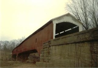
The West Union Covered Bridge is north-northeast of Montezuma, Indiana. The two-span Burr Arch Truss covered bridge structure was built by Joseph J. Daniels in 1876. It is notable for being the longest standing covered bridge in Parke County, and one of the nation's best-preserved examples of the Burr truss.
The Armiesburg Covered Bridge was on the south side of Armiesburg, Indiana. The Long Truss with arch covered bridge structure was built by Henry Wolf in 1907 and destroyed by the Great Flood of 1913.
The Coal Creek Covered Bridge was on the east side of Lodi, Indiana. The Burr Arch single span style bridge crossed Coal Creek and was built by J. J. Daniels in 1869. It was destroyed by arson on June 28, 1992.
The Grange Corner Covered Bridge was west of Grange Corner, Indiana. The single-span Burr Arch covered bridge structure was built by the J. J. Daniels in 1899 and destroyed by flood in 1968.
The Hargrave Covered Bridge was west of Portland Mills, Indiana. The single-span Burr Arch covered bridge structure was built by J. J. Daniels in 1847 and destroyed by a flood in 1913.
The Hollandsburg Covered Bridge was southeast of Hollandsburg, Indiana. The single-span Burr Arch covered bridge structure was built by J. J. Daniels in 1872 and torn down in 1930 during the expansion of U.S. Route 36 (US 36).
The Plank Road Covered Bridge was east of Rockville, Indiana. The single-span Burr Arch covered bridge structure was built by Henry Wolf in either 1854 or 1859 and destroyed in the Great Flood of 1913.
The Red Covered Bridge was east of Rosedale, Indiana. The double-span Burr Arch covered bridge structure was built by J. J. Daniels in 1880 and destroyed by arson on October 13, 1976.
The Roseville Covered Bridge 1866, also known as the Coxville covered bridge, is in Coxville also known as Roseville. The double span Burr Arch covered bridge structure was built by Joseph J. Daniels in 1866 and destroyed by arson in 1910. This was the second bridge at this location.
The Turkey Run Covered Bridge was north of Marshall, Indiana. The single-span Modified Queen Truss covered bridge structure was built by Joseph J. Daniels in 1865, 1866 or 1884, according to several conflicting sources, and dismantled in 1914 by order of the Parke County Commissioners, the abutments remain. It was one of two Queen Truss type covered bridges, the other being the JH Russell Covered Bridge
The Weisner Covered Bridge was southwest of Catlin, Indiana. The single-span King Post covered bridge structure was built by Joseph A. Britton in 1908 and destroyed by flood in 1957.
The Lusk Covered Bridge was once located north of Marshall, Indiana, United States. Two single-span dual lane Lattice Truss covered bridges were located at the site, one of which replaced the other. Salmon Lusk constructed the first bridge in 1840, and after its destruction by flood in 1847, Lusk constructed the second. Both bridges were located on private land; the only other such covered bridges in Parke County were the State Sanitorium Covered Bridge, the JH Russell Covered Bridge, and the Clinton Toll Bridge.