Putnam County is a county located in the U.S. state of Indiana. As of the 2020 United States Census, the population was 36,726. The county seat is Greencastle. The county was named for Israel Putnam, a hero in the French and Indian War and a general in the American Revolutionary War. The county was created in 1821 and organized in April 1822.

The Crooks Covered Bridge is a single span Burr Arch Truss structure that crosses Little Raccoon Creek built in 1855-1856 by Henry Wolf just southeast of Rockville, Indiana.

The covered bridges of Parke County are well-known tourist attractions in Parke County, Indiana, United States, which touts itself as the "Covered Bridge Capital of the World". The county claims to have more covered bridges than any other county in the United States. This is due to several reasons, mainly due to the numerous streams and creeks in the county, and having the natural resources and designers to build the bridges.

The Jackson Covered Bridge also known as the Rockport Covered Bridge is located in the 'forgotten town' of Rockport, northwest of Bloomingdale, Parke County, Indiana, USA.

The Leatherwood Station Covered Bridge is a single span double Burr Arch Truss covered bridge structure that was built by Joseph A. Britton & Son in 1899. Originally it had sandstone abutments but when it was moved to Billie Creek Village they were replaced with concrete abutments with sandstone showing.

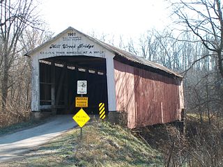
The Mill Creek Covered Bridge also known as "Thompson's Ford Covered Bridge," "Tow Path Covered Bridge," or "Earl Ray Covered Bridge" crosses Wabash Mill Creek (historic) southwest of Tangier, Indiana. It is a single span Burr Arch Truss covered bridge structure that was built by D. M. Brown in 1907.

The Roseville Covered Bridge, also known as the Coxville covered bridge, is southeast of Mecca, Indiana. The double span Burr Arch covered bridge structure was built by Joseph J. Daniels in 1910. This is the third bridge at this location.
Joseph Albert Britton (1839–1929), most commonly known as J.A. Britton, was a builder of bridges in Indiana. He created many works that survive and are listed on the U.S. National Register of Historic Places.

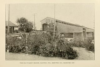
The Clinton Covered Bridge was on the east side of Clinton, Indiana. The Long Truss style bridge with double lanes, triple covered spans and one 70 foot draw span was built by Hirem Bishop in 1852-53 and destroyed by electric cutting wire in 1899.
The Grange Corner Covered Bridge was west of Grange Corner, Indiana. The single-span Burr Arch covered bridge structure was built by the J. J. Daniels in 1899 and destroyed by flood in 1968.
The Hargrave Covered Bridge was west of Portland Mills, Indiana. The single-span Burr Arch covered bridge structure was built by J. J. Daniels in 1847 and destroyed by a flood in 1913.
The Harrison Covered Bridge was north of West Union, Indiana. The double-span Burr Arch covered bridge structure was built by J. J. Daniels in 1866 and damaged by flood waters in December 1875.
The Jessup Covered Bridge was north of Jessup, Indiana. The single-span Burr Arch covered bridge structure was built by the Jefferson P. Van Fossen in 1910 and destroyed by flood in 1989.
The Plank Road Covered Bridge was east of Rockville, Indiana. The single-span Burr Arch covered bridge structure was built by Henry Wolf in either 1854 or 1859 and destroyed in the Great Flood of 1913.
The Red Covered Bridge was east of Rosedale, Indiana. The double-span Burr Arch covered bridge structure was built by J. J. Daniels in 1880 and destroyed by arson on October 13, 1976.
The Roaring Creek Covered Bridge was northeast of Annapolis, Indiana. The single-span covered bridge structure was built by Henry Wolf in 1863 and dismantled in 1923-25.
The Roseville Covered Bridge 1866, also known as the Coxville covered bridge, is in Coxville also known as Roseville. The double span Burr Arch covered bridge structure was built by Joseph J. Daniels in 1866 and destroyed by arson in 1910. This was the second bridge at this location.
The Star Mill Covered Bridge was north of West Union, Indiana. The double-span Burr Arch covered bridge structure was built by J. J. Daniels in 1861 and destroyed by flood waters in 1866.
The Turkey Run Covered Bridge was north of Marshall, Indiana. The single-span Modified Queen Truss covered bridge structure was built by Joseph J. Daniels in 1865, 1866 or 1884, according to several conflicting sources, and dismantled in 1914 by order of the Parke County Commissioners, the abutments remain. It was one of two Queen Truss type covered bridges, the other being the JH Russell Covered Bridge


