
The Mansfield Covered Bridge is a Double Burr Arch double span truss bridge located on Mansfield Road (historic) and Big Raccoon Creek in Mansfield southeast of Rockville in Parke County, Indiana. Built by Joseph J. Daniels in 1867 at a cost of $12,200. At 279 ft (85 m) it is the second longest covered bridge left in Parke County. This Historic Site rest on land provided by Indiana DNR, of Parke County, Indiana and is open to the public all year.

The Nevins Covered Bridge is a single span Burr Arch Truss covered bridge that crosses Little Raccoon Creek on County Road 130 East, just southeast of Catlin, Indiana. It was built in 1920 by Joseph A. Britton and Son. Prior to the reconstruction of the Bridgeton Bridge in 2006, the Nevins Bridge was the newest covered bridge in Parke County.

The Beeson Covered Bridge originally crossed Roaring Creek, one mile (1.6 km) northwest of Marshall, Indiana, on County Road 216, in Washington Township, Parke County. The bridge was moved to its current location in Billie Creek Village in December 1979.

The covered bridges of Parke County are well-known tourist attractions in Parke County, Indiana, United States, which touts itself as the "Covered Bridge Capital of the World". The county claims to have more covered bridges than any other county in the United States. This is due to several reasons, mainly due to the numerous streams and creeks in the county, and having the natural resources and designers to build the bridges.

The Cox Ford Covered Bridge is a covered bridge that crosses Sugar Creek along the western edge of Turkey Run State Park, in Parke County, in the U.S. state of Indiana.

The Portland Mills Covered Bridge is the second oldest covered bridge in Parke County, Indiana, being built the same year as the Crooks Covered Bridge. It is a single span Burr Arch Truss covered bridge that was built by Henry Wolf in 1856.
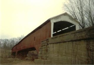
The West Union Covered Bridge formerly carried Tow Path Road over Sugar Creek north-northeast of Montezuma, Indiana. The two-span Burr Arch Truss covered bridge structure was built by Joseph J. Daniels in 1876. It is notable for being the longest standing covered bridge in Parke County, and one of the nation's best-preserved examples of the Burr truss.

The Wilkins Mill Covered Bridge is north of Rockville, Indiana, United States. The single span Burr Arch Truss covered bridge structure was built by William Hendricks in 1906. The bridge is 120 feet (37 m) long, 16 feet (4.9 m) wide, and 13 feet (4.0 m) high.
The Adams Covered Bridge was east of Rockville, Indiana. The single-span Burr Arch covered bridge structure was built by Adams Construction in 1907 and destroyed by flood in 1969.
The Armiesburg Covered Bridge was on the south side of Armiesburg, Indiana. The Long Truss with arch covered bridge structure was built by Henry Wolf in 1907 and destroyed by the Great Flood of 1913.
The Dooley Station Covered Bridge was east of Dooley Station, Indiana. The Burr arch truss style single span covered bridge crossed Little Raccoon Creek and was built by W.C. Carty in 1917 and destroyed by arson in 1960.
The Grange Corner Covered Bridge was west of Grange Corner, Indiana. The single-span Burr Arch covered bridge structure was built by the J. J. Daniels in 1899 and destroyed by flood in 1968.
The Hargrave Covered Bridge was west of Portland Mills, Indiana. The single-span Burr Arch covered bridge structure was built by J. J. Daniels in 1847 and destroyed by a flood in 1913.
The Harrison Covered Bridge was north of West Union, Indiana. The double-span Burr Arch covered bridge structure was built by J. J. Daniels in 1866 and damaged by flood waters in December 1875.
The Hollandsburg Covered Bridge was southeast of Hollandsburg, Indiana. The single-span Burr Arch covered bridge structure was built by J. J. Daniels in 1872 and torn down in 1930 during the expansion of U.S. Route 36 (US 36).
The Moore Covered Bridge was northeast of Judson, Indiana. The single-span Burr Arch covered bridge structure was built by the Joseph A. Britton in 1909 and destroyed by flood in 1957.
The Plank Road Covered Bridge was east of Rockville, Indiana. The single-span Burr Arch covered bridge structure was built by Henry Wolf in either 1854 or 1859 and destroyed in the Great Flood of 1913.
The Star Mill Covered Bridge was north of West Union, Indiana. The double-span Burr Arch covered bridge structure was built by J. J. Daniels in 1861 and destroyed by flood waters in 1866.
The Lusk Covered Bridge was once located north of Marshall, Indiana, United States. Two single-span dual lane Lattice Truss covered bridges were located at the site, one of which replaced the other. Salmon Lusk constructed the first bridge in 1840, and after its destruction by flood in 1847, Lusk constructed the second. Both bridges were located on private land; the only other such covered bridges in Parke County were the State Sanitorium Covered Bridge, the JH Russell Covered Bridge, and the Clinton Toll Bridge.
