The Revolutionary War, however, delayed many grantees from taking up their claims. Only 10 families resided at Sudbury-Canada when it was plundered on August 3, 1781, during the last Indian attack in Maine. Two inhabitants, Benjamin Clark and Nathaniel Segar, were abducted and held captive in Quebec until the war's conclusion, after which the community grew rapidly. On June 10, 1796, Sudbury-Canada Plantation was incorporated as Bethel,[4] the name taken from the Book of Genesis and meaning "House of God."[5][6]
In 1802, a trade road (now Route 26) was completed from Portland to Errol, New Hampshire, passing through Bethel and bringing growth. More settlers and businesses arrived. Crops were planted on fertile intervales and meadows formerly cultivated by Indians. Bethel became one of the best farming towns in the state, especially for hay and potatoes. In winter, farmers found work logging, with the lumber cut at sawmills operated by water power from streams. Other manufacturers produced flour, leather and harnesses, furniture, boots and shoes, carriages, and marble and granite work. The Bethel House, a large hotel, was built in 1833.
Ferry across the Androscoggin River at West Bethel in 1909
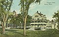
The Prospect Hotel, largest in Bethel, as it appeared in 1909
Church Street in c.1912
Main and Church streets in 1913
On March 10, 1851, the Atlantic and St. Lawrence Railroad opened to Bethel, carrying freight and summer tourists eager to escape the noise, heat and pollution of cities. Between the Civil War and World War I, Bethel was a fashionable summer resort. Several hotels were built facing the common or on Bethel Hill. Begun in 1863, The Prospect Hotel was the largest, with a cupola from which guests could observe the mountains. Tally-hocoaches provided tours through wilderness landscapes of the White Mountains and Maine. Dr. John G. Gehring's famed clinic for nervous disorders attracted many wealthy patients. Between 1897 and 1926, a number of figures in the music world[who?] performed at the Maine Music Festivals organized by William Rogers Chapman.[citation needed] But with the advent of the automobile, tourists were no longer restricted by the limits of train service, but were free to explore. Consequently, many big hotels built near the tracks lost patrons, declined and were eventually torn down. The Prospect Hotel was largely destroyed by fire in 1911. Although transportation patterns and preferences in vacation accommodations have changed, Bethel remains a tourist destination for its natural setting, history and recreation resources.[citation needed]
Organizational development
Beginning in 1947 Bethel became the site of "pioneering work" in organizational development.[citation needed] Led by psychologist Kurt Lewin and, eventually, colleagues like Ken Benne and Ron Lippitt, research was conducted that helped lay the foundation for organizational development's theory and practice. T-groups and sensitivity training were refined to apply behavioral science to individual self-awareness and group functioning, in the service of organizational efficiency and productivity. The National Training Laboratories (NTL) was organized by Lewin to lead this work, with much or it conducted during summer seasons at Gould Academy. These seasonal research and training sessions were well attended, attracting participants from across the country and around the world. Increasingly, NTL became an important part of Bethel's economy, especially as the traditional wood product mill industries went into decline. Although NTL moved its headquarters to Alexandria, Virginia in 2008, it continues to maintain a small summer legacy presence in Bethel.[7]
Geography
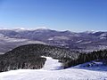
Bethel is located on the western edge of the Oxford Hills and on the southern rim of the rugged Mahoosuc Range. Nearby Locke and Barker Mountains lie within the Mahoosuc Range, which is a subrange of the White Mountains, a part of the Northern Appalachian Mountains. Bethel and the surrounding area is drained by the Androscoggin River and its tributaries: the Alder, Pleasant and Sunday Rivers. The north edge of Songo Pond lies within Bethel's boundary. Just south of the boundary are located South Pond, North Pond and Bryant Ponds. According to the United States Census Bureau, the town has a total area of 65.91 square miles (170.71km2), of which 64.60 square miles (167.31km2) is land and 1.31 square miles (3.39km2) is water.[2]
Memorial to American Civil War veterans
Bethel Public Library
Cole Block Bethel Maine
Gould Academy
Bethel's Olympia Snow Woman (122ft, 2008), named for Senator Olympia Snowe
As of the census[9] of 2010, there were 2,607 people, 1,121 households, and 707 families living in the town. The population density was 40.4 inhabitants per square mile (15.6/km2). There were 1,861 housing units at an average density of 28.8 per square mile (11.1/km2). The racial makeup of the town was 97.2% White, 0.5% African American, 0.2% Native American, 0.5% Asian, 0.5% from other races, and 1.0% from two or more races. Hispanic or Latino of any race were 1.2% of the population.
There were 1,121 households, of which 29.7% had children under the age of 18 living with them, 47.6% were married couples living together, 9.5% had a female householder with no husband present, 5.9% had a male householder with no wife present, and 36.9% were non-families. 29.1% of all households were made up of individuals, and 13.2% had someone living alone who was 65 years of age or older. The average household size was 2.33 and the average family size was 2.83.
The median age in the town was 42.9 years. 23.3% of residents were under the age of 18; 6.1% were between the ages of 18 and 24; 23.6% were from 25 to 44; 31.1% were from 45 to 64; and 15.9% were 65 years of age or older. The gender makeup of the town was 48.0% male and 52.0% female.
2000 census
As of the census[10] of 2000, there were 2,411 people, 1,034 households, and 677 families living in the town. The population density was 37.2 inhabitants per square mile (14.4/km2). There were 1,448 housing units at an average density of 22.3 per square mile (8.6/km2). The racial makeup of the town was 98.09% White, 0.21% African American, 0.37% Native American, 0.50% Asian, 0.12% from other races, and 0.71% from two or more races. Hispanic or Latino of any race were 0.79% of the population.
There were 1,034 households, out of which 27.3% had children under the age of 18 living with them, 52.5% were married couples living together, 9.4% had a female householder with no husband present, and 34.5% were non-families. 26.9% of all households were made up of individuals, and 10.0% had someone living alone who was 65 years of age or older. The average household size was 2.33 and the average family size was 2.77.
In the town, the population was spread out, with 22.4% under the age of 18, 6.8% from 18 to 24, 27.4% from 25 to 44, 27.6% from 45 to 64, and 15.8% who were 65 years of age or older. The median age was 41 years. For every 100 females, there were 96.0 males. For every 100 females age 18 and over, there were 94.6 males.
The median income for a household in the town was $33,803, and the median income for a family was $38,669. Males had a median income of $31,569 versus $18,859 for females. The per capita income for the town was $17,458. About 8.0% of families and 10.2% of the population were below the poverty line, including 11.2% of those under age 18 and 5.7% of those age 65 or over.
Timothy J. Carter, ME Representative for the 25th Congress and Luther C. Carter, NY Representative for the 36th Congress, both sons of Dr. Timothy Carter, the first physician to settle in the town
↑Maine League of Historical Societies and Museums (1970). Doris A. Isaacson (ed.). Maine: A Guide 'Down East'. Rockland, Me: Courier-Gazette, Inc. p.366.
This page is based on this Wikipedia article Text is available under the CC BY-SA 4.0 license; additional terms may apply. Images, videos and audio are available under their respective licenses.